

Storm Data and Unusual Weather Phenomena - CIG
Storm Data and Unusual Weather Phenomena - CIG
Storm Data and Unusual Weather Phenomena - CIG

You also want an ePaper? Increase the reach of your titles
YUMPU automatically turns print PDFs into web optimized ePapers that Google loves.
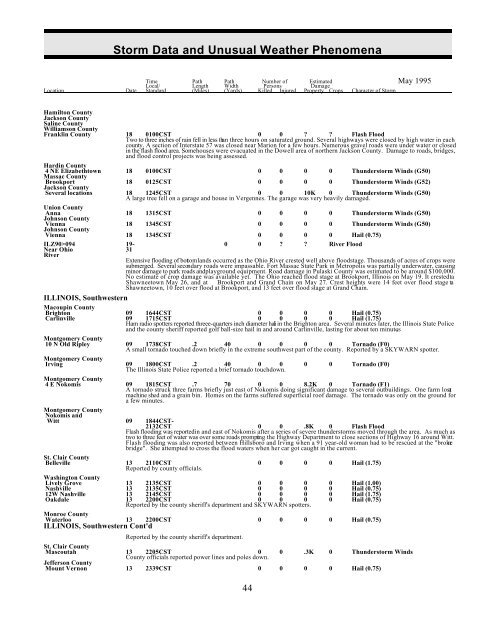
<strong>Storm</strong> <strong>Data</strong> <strong>and</strong> <strong>Unusual</strong> <strong>Weather</strong> <strong>Phenomena</strong><br />
Time Path Path Number of Estimated May 1995<br />
Local/ Length Width Persons Damage<br />
Location Date St<strong>and</strong>ard (Miles) (Yards) Killed Injured Property Crops Character of <strong>Storm</strong><br />
Hamilton County<br />
Jackson County<br />
Saline County<br />
Williamson County<br />
Franklin County 18 0100CST 0 0 ? ? Flash Flood<br />
Two to three inches of rain fell in less than three hours on saturated ground. Several highways were closed by high water in each<br />
county. A section of Interstate 57 was closed near Marion for a few hours. Numerous gravel roads were under water or closed<br />
in the flash flood area. Some houses were evacuated in the Dowell area of northern Jackson County. Damage to roads, bridges,<br />
<strong>and</strong> flood control projects was being assessed.<br />
Hardin County<br />
4 NE Elizabethtown 18 0100CST 0 0 0 0 Thunderstorm Winds (G50)<br />
Massac County<br />
Brookport 18 0125CST 0 0 0 0 Thunderstorm Winds (G52)<br />
Jackson County<br />
Several locations 18 1245CST 0 0 10K 0 Thunderstorm Winds (G50)<br />
A large tree fell on a garage <strong>and</strong> house in Vergennes. The garage was very heavily damaged.<br />
Union County<br />
Anna 18 1315CST 0 0 0 0 Thunderstorm Winds (G50)<br />
Johnson County<br />
Vienna 18 1345CST 0 0 0 0 Thunderstorm Winds (G50)<br />
Johnson County<br />
Vienna 18 1345CST 0 0 0 0 Hail (0.75)<br />
ILZ90>094 19- 0 0 ? ? River Flood<br />
Near Ohio 31<br />
River<br />
Extensive flooding of botoml<strong>and</strong>s occurred as the Ohio River crested well above floodstage. Thous<strong>and</strong>s of acres of crops were<br />
submerged. Several secondary roads were impassable. Fort Massac State Park in Metropolis was partially underwater, causing<br />
minor damage to park roads <strong>and</strong> playground equipment. Road damage in Pulaski County was estimated to be around $100,000.<br />
No estimate of crop damage was available yet. The Ohio reached flood stage at Brookport, Illinois on May 19. It crested ta<br />
Shawneetown May 26, <strong>and</strong> at<br />
Shawneetown, 10 feet over flood at Brookport, <strong>and</strong> 13 feet over flood stage at Gr<strong>and</strong> Chain.<br />
ILLINOIS, Southwestern<br />
Macoupin County<br />
Brighton 09 1644CST 0 0 0 0 Hail (0.75)<br />
Carlinville 09 1715CST 0 0 0 0 Hail (1.75)<br />
Brookport <strong>and</strong> Gr<strong>and</strong> Chain on May 27. Crest heights were 14 feet over flood stage ta<br />
Ham radio spotters reported threee-quarters inch diameter hail in the Brighton area. Several minutes later, the Illinois State Police<br />
<strong>and</strong> the county sheriff reported golf ball-size hail in <strong>and</strong> around Carlinville, lasting for about ten minutes .<br />
Montgomery County<br />
10 N Old Ripley 09 1738CST .2 40 0 0 0 0 Tornado (F0)<br />
A small tornado touched down briefly in the extreme southwest part of the county. Reported by a SKYWARN spotter.<br />
Montgomery County<br />
Irving 09 1800CST .2 40 0 0<br />
The Illinois State Police reported a brief tornado touchdown.<br />
0 0 Tornado (F0)<br />
Montgomery County<br />
4 E Nokomis 09 1815CST .7 70 0 0 8.2K 0 Tornado (F1)<br />
A tornado struck three farms briefly just east of Nokomis doing significant damage to several outbuildings. One farm lost a<br />
machine shed <strong>and</strong> a grain bin. Homes on the farms suffered superficial roof damage. The tornado was only on the ground for<br />
a few minutes.<br />
Montgomery County<br />
Nokomis <strong>and</strong><br />
0 0 .8K 0 Flash Flood<br />
Flash flooding was reported in <strong>and</strong> east of Nokomis after a series of severe thunderstorms moved through the area. As much as<br />
two to three feet of water was over some roads prompting the Highway Department to close sections of Highway 16 around Witt.<br />
Flash flooding was also reported between Hillsboro <strong>and</strong> Irving when a 91 year-old woman had to be rescued at the "broken<br />
bridge". She attempted to cross the flood waters when her car got caught in the current.<br />
Witt 09 1844CST-<br />
2132CST<br />
St. Clair County<br />
Belleville<br />
officials.<br />
13<br />
Reported<br />
2110CST<br />
by county<br />
0 0 0 0 Hail (1.75)<br />
Washington County<br />
Lively Grove 13 2135CST 0 0 0 0 Hail (1.00)<br />
Nashville 13 2135CST 0 0 0 0 Hail (0.75)<br />
12W Nashville 13 2145CST 0 0 0 0 Hail (1.75)<br />
Oakdale 13 2200CST 0 0 0 0 Hail (0.75)<br />
Reported by the county sheriff's department <strong>and</strong> SKYWARN spotters.<br />
Monroe County<br />
Waterloo<br />
ILLINOIS, Southwestern<br />
13<br />
Cont'd<br />
2200CST 0 0 0 0 Hail (0.75)<br />
Reported by the county sheriff's department.<br />
St. Clair County<br />
Mascoutah 13 2205CST 0 0 .3K 0 Thunderstorm Winds<br />
County officials reported power lines <strong>and</strong> poles down.<br />
Jefferson County<br />
Mount Vernon 13 2339CST 0 0 0 0 Hail (0.75)<br />
44


