

Storm Data and Unusual Weather Phenomena - CIG
Storm Data and Unusual Weather Phenomena - CIG
Storm Data and Unusual Weather Phenomena - CIG

Create successful ePaper yourself
Turn your PDF publications into a flip-book with our unique Google optimized e-Paper software.
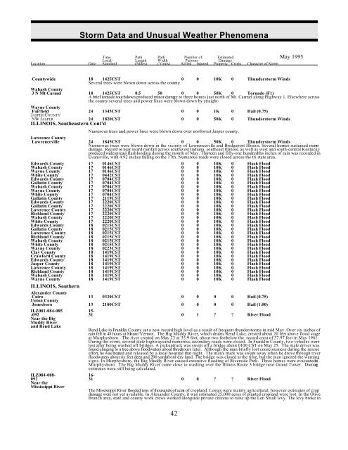
<strong>Storm</strong> <strong>Data</strong> <strong>and</strong> <strong>Unusual</strong> <strong>Weather</strong> <strong>Phenomena</strong><br />
Time Path Path Number of Estimated May 1995<br />
Local/ Length Width Persons Damage<br />
Location Date St<strong>and</strong>ard (Miles) (Yards) Killed Injured Property Crops Character of <strong>Storm</strong><br />
Countywide 18 1425CST 0<br />
Several trees were blown down across the county.<br />
0 10K 0 Thunderstorm Winds<br />
Wabash County<br />
3 N Mt Carmel 18 1425CST 0.5 50 0 0 50K 0 Tornado (F1)<br />
A brief tornado touchdown produced minor damage to three homes just north of Mt. Carmel along Highway 1. Elsewhere across<br />
the county several trees <strong>and</strong> power lines were blown down by straight-<br />
Wayne County<br />
NW JASPER 24 1820CST 0 0 50K 0 Thunderstorm Winds<br />
ILLINOIS, Southeastern Cont'd<br />
Fairfield<br />
JASPER COUNTY<br />
24 1345CST 0 0 1K 0 Hail (0.75)<br />
Numerous trees <strong>and</strong> power lines were blown down over northwest Jasper county.<br />
Lawrence County<br />
Lawrenceville 24 1845CST 0 0 50K 0 Thunderstorm Winds<br />
Numerous trees were blown down in the vicinity of Lawrenceville <strong>and</strong> Bridgeport Illinois. Several homes sustained minor<br />
damage. Record or near record rainfall across southwest Indiana, southeast Illinois, as well as west <strong>and</strong> south-central Kentucky<br />
produced widespread flashlooding during the month of May. Thirteen <strong>and</strong> fifty-one hundredths inches of rain was recorded in<br />
Evansville, with 4.92 inches falling on the 17th. Numerous roads were closed across the tri state area.<br />
Edwards County 17 0146CST 0 0 10K 0 Flash Flood<br />
Wabash County 17 0146CST 0 0 10K 0 Flash Flood<br />
Wayne County 17 0146CST 0 0 10K 0 Flash Flood<br />
White County 17 0442CST 0 0 10K 0 Flash Flood<br />
Edwards County 17 0704CST 0 0 10K 0 Flash Flood<br />
Gallatin County 17 0704CST 0 0 10K 0 Flash Flood<br />
Wabash County 17 0704CST 0 0 10K 0 Flash Flood<br />
Wayne County 17 0704CST 0 0 10K 0 Flash Flood<br />
White County 17 0704CST 0 0 10K 0 Flash Flood<br />
Gallatin County 17 2119CST 0 0 10K 0 Flash Flood<br />
Edwards County 17 2220CST 0 0 10K 0 Flash Flood<br />
Gallatin County 17 2220CST 0 0 10K 0 Flash Flood<br />
Lawrence County 17 2220CST 0 0 10K 0 Flash Flood<br />
Richl<strong>and</strong> County 17 2220CST 0 0 10K 0 Flash Flood<br />
Wabash County 17 2220CST 0 0 10K 0 Flash Flood<br />
White County 17 2220CST 0 0 10K 0 Flash Flood<br />
Edwards County 18 0215CST 0 0 10K 0 Flash Flood<br />
Gallatin County 18 0215CST 0 0 10K 0 Flash Flood<br />
Lawrence County 18 0215CST 0 0 10K 0 Flash Flood<br />
Richl<strong>and</strong> County 18 0215CST 0 0 10K 0 Flash Flood<br />
Wabash County 18 0215CST 0 0 10K 0 Flash Flood<br />
White County 18 0215CST 0 0 10K 0 Flash Flood<br />
Wayne County 18 0223CST 0 0 10K 0 Flash Flood<br />
Clay County 18 1419CST 0 0 10K 0 Flash Flood<br />
Crawford County 18 1419CST 0 0 10K 0 Flash Flood<br />
Edwards County 18 1419CST 0 0 10K 0 Flash Flood<br />
Jasper County 18 1419CST 0 0 10K 0 Flash Flood<br />
Lawrence County 18 1419CST 0 0 10K 0 Flash Flood<br />
Richl<strong>and</strong> County 18 1419CST 0 0 10K 0 Flash Flood<br />
Wabash County 18 1419CST 0 0 10K 0 Flash Flood<br />
Wayne County 18 1419CST 0 0 10K 0 Flash Flood<br />
ILLINOIS, Southern<br />
Alex<strong>and</strong>er County<br />
Cairo 13 0330CST 0 0 0 0 Hail (0.75)<br />
Union County<br />
Jonesboro 13 2100CST 0 0 0 0 Hail (1.00)<br />
ILZ081-084-085 15-<br />
-092 31 0 1 ? ? River Flood<br />
Near the Big<br />
Muddy River<br />
<strong>and</strong> Rend Lake<br />
Rend Lake in Franklin County set a new record high level as a result of frequent thunderstorms in mid May. Over six inches of<br />
rain fell in 48 hours at Mount Vernon. The Big Muddy River, which drains Rend Lake, crested about 20 feet above flood stage<br />
at Murphysboro. The river crested on May 23 at 35.9 feet, about two feet below the record crest of 37.97 feet in May 1961.<br />
During the event, several state highways <strong>and</strong> numerous secondary roads were closed. In Franklin County, two vehicles were<br />
lost after being washed off bridges. A pickup truck was swept off a bridge about 0100 CST on May 25. The male driver was<br />
found clinging to a tree above floodwaters about three hours later. Although the man briefly lost consciousness during the rescue<br />
effort, he was treated <strong>and</strong> released by a local hospital that night. The man's truck was swept away when he drove through river<br />
floodwaters about six feet deep <strong>and</strong> 200 yards from dry l<strong>and</strong>. The bridge was closed at the time, but the man ignored the warning<br />
signs. In Murphysboro, the Big Muddy River caused extensive flooding of Riverside Park. Three homes were evacuated ni<br />
Murphysboro. The Big Muddy River came close to washing over the Illinois Route 3 bridge near Gr<strong>and</strong> Tower. Damage<br />
estimates were still being calculated.<br />
ILZ084-088- 16-<br />
092 31 0 0 ? ? River Flood<br />
Near the<br />
Mississippi River<br />
The Mississippi River flooded tens of thous<strong>and</strong>s of acres of cropl<strong>and</strong>. Losses were mainly agricultural, however estimates of crop<br />
damage were not yet available. In Alex<strong>and</strong>er County, it was estimated 25,000 acres of planted cropl<strong>and</strong> were lost. In the Olive<br />
Branch area, state <strong>and</strong> county work crews worked alongside private citizens to raise up the Len Small levy. The levy broke in<br />
42


