

Storm Data and Unusual Weather Phenomena - CIG
Storm Data and Unusual Weather Phenomena - CIG
Storm Data and Unusual Weather Phenomena - CIG

You also want an ePaper? Increase the reach of your titles
YUMPU automatically turns print PDFs into web optimized ePapers that Google loves.
<strong>Storm</strong> <strong>Data</strong> <strong>and</strong> <strong>Unusual</strong> <strong>Weather</strong> <strong>Phenomena</strong><br />
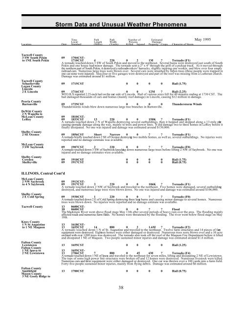
Time Path Path Number of Estimated May 1995<br />
Local/ Length Width Persons Damage<br />
Location Date St<strong>and</strong>ard (Miles) (Yards) Killed Injured Property Crops Character of <strong>Storm</strong><br />
Tazwell County<br />
3 SW South Pekin 09 1704CSTto<br />
1NE South Pekin 1710CST 4 220 0 2 1M ? Tornado (F1)<br />
A tornado touched down 3 SW of South Pekin <strong>and</strong> moved to the northeast. Several barns were destroyed just south of South<br />
Pekin <strong>and</strong> one house had minor damage. The tornado sent a 2" x 4" through the grill of a pickup truck. As it moved through<br />
the northern part of South Pekin, it destroyed a railroad workers' barracks, slightly injuring one worker, <strong>and</strong> blew over four empty<br />
railroad cars. Numerous large trees were blown over. Several cars were smashed by fallen trees (three people were trapped in<br />
one car-none were injured). Also, four or five garages were destroyed <strong>and</strong> part of the roof was missing from a Lutheran church.<br />
Damage was estimated around $1 million.<br />
Tazwell County<br />
Schaeferville 09 1715CST 0 0 0 0 Hail (1.75)<br />
Logan County<br />
Lincoln<br />
2 E Lincoln 09 1716CST 0 0 12M ? Hail (2.25)<br />
WFO ILX reported 2.25-inch hail on the east side of Lincoln. Hail of various sizes fell for 40 minutes ending at 1730 CST. The<br />
hail damaged thous<strong>and</strong>s of cars <strong>and</strong> homes (mainly roof damage) in Lincoln, causing $12 million in damage.<br />
Peoria County<br />
Bartonville 09 1725CST 0 0 0 0 Thunderstorm Winds<br />
Thunderstorms winds blew down numerous large tree branches in Bartonville.<br />
DeWitt County<br />
2 N Wapella to<br />
McLean County 09 1810CST-<br />
LeRoy 09 1833CST 13 220 0 0 150K ? Tornado (F1)<br />
A tornado touched down 2 N of Wapella destroying several outbuildings, then it hopped <strong>and</strong> skipped along a 13-mile pat h<br />
causing sporadic damage along the way, mainly to trees <strong>and</strong> power lines. It did damage two to three homes in LeRoy before it<br />
finally dissipated. No one was injured <strong>and</strong> damage was estimated around $150,000.<br />
Shelby County<br />
2 SE Oconee 09 1856CST Short Narrow 0 0 ? ? Tornado (F1)<br />
A tornado briefly touched down 2 SE of Oconee destroying two mobile homes, as well as, several outbuildings. No injuries were<br />
reported <strong>and</strong> no damage estimate was available.<br />
McLean County<br />
3 SW Saybrook 09 1907CST 2 220 0 0 ? ? Tornado (F0)<br />
A tornado touched down 3 SW of Saybrook knocking down numerous large trees before lifting 2 NW of Saybrook. No one was<br />
injured <strong>and</strong> no damage estimates were available.<br />
Shelby County<br />
Cowden 09 1910CST 0 0 0 0 Hail (1.75)<br />
Shelbyville 09 1917CST 0 0 0 0 Hail (0.75)<br />
ILLINOIS, Central Cont'd<br />
McLean County<br />
2 NW Saybrook 09 1913CSTto<br />
4 N Saybrook 09 1917CST 3 220 0 0 106K ? Tornado (F1)<br />
A tornado touched down 2 NW of Saybrook <strong>and</strong> traveled to the northeast. Five homes were damaged, several outbuilding s<br />
destroyed, <strong>and</strong> numerous large trees were blown down. No one was injured <strong>and</strong> damage was estimated around $106,000.<br />
Shelby County<br />
2 E Cold Spring 09 1930CST 1 220 0 0 ? ? Tornado (F0)<br />
A tornado touched down 2 E of Cold Spring destroying three large barns <strong>and</strong> causing minor damage to several homes. Numerous<br />
trees were blown down. No injuries were reported <strong>and</strong> no damage estimate was available.<br />
Tazwell County 13 0600CST-<br />
18 0600CST 0 0 ? ? Flood<br />
The Mackinaw River went above flood stage May 13th after several periods of heavy rain over the area. The flooding mainly<br />
affected roads <strong>and</strong> numerous farm fields. No homes were threatened by the flooding. The river went below flood stage on May<br />
18th.<br />
Knox County<br />
1 N St Augustine 13 1618CSTto<br />
1 NE Maquon 13 1655CST 14 880 0 2 1.6M ? Tornado (F2)<br />
A tornado touched down 1 N of St. Augustine <strong>and</strong> traveled to the northeast. Twelve farm structures <strong>and</strong> 14 pieces of farm<br />
equipment were destroyed. Eighteen homes were either damaged or destroyed. Numerous trees were blown over <strong>and</strong> a 10 acre<br />
orchard with over 1200 trees was destroyed. The tornado also took off the roof of the Maquon Fire Department before it lifted<br />
<strong>and</strong> dissipated 1 NE of Maquon. Two people sustained minor injuries <strong>and</strong> damage was estimated around $1.6 million.<br />
Fulton County<br />
Lewistown 13 1655CST 0 0 0 0 Hail (1.25)<br />
Fulton County<br />
1 NE Ipava to 13 1655CST-<br />
2 NE Lewistown 13 1706CST 7 880 0 45 6M ? Tornado (F4)<br />
A tornado touched down 1 NE of Ipava <strong>and</strong> traveled to the northeast for seven miles, lifting <strong>and</strong> dissipating 2 NE of Lewistown.<br />
The tops of some high power line structures were broken off <strong>and</strong> 12 homes were destroyed. Numerous livestock were killed.<br />
Numerous cars <strong>and</strong> farm equipment were either damaged or destroyed. One car was thrown over a 100 yards into a farm field.<br />
Forty-five people sustained minor injuries, mainly from flying debris. Damage was estimated around $6 million.<br />
Fulton County<br />
Smithfield 13 1700CST 0 0 0 0 Hail (0.75)<br />
Mason County<br />
3 NE Goofy Ridge to<br />
38


