

Storm Data and Unusual Weather Phenomena - CIG
Storm Data and Unusual Weather Phenomena - CIG
Storm Data and Unusual Weather Phenomena - CIG

Create successful ePaper yourself
Turn your PDF publications into a flip-book with our unique Google optimized e-Paper software.
<strong>Storm</strong> <strong>Data</strong> <strong>and</strong> <strong>Unusual</strong> <strong>Weather</strong> <strong>Phenomena</strong><br />
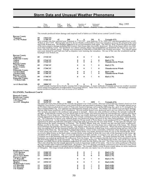
Time Path Path Number of Estimated May 1995<br />
Local/ Length Width Persons Damage<br />
Location Date St<strong>and</strong>ard (Miles) (Yards) Killed Injured Property Crops Character of <strong>Storm</strong><br />
The tornado produced minor damage <strong>and</strong> emptied itself of debris as it lifted across central Carroll County.<br />
Bureau County<br />
Neponset 09 1701CSTto<br />
2 NE Walnut 09 1730CST 42 300 0 0 3M 0 Tornado (F3)<br />
This tornado was first reported near Neponset at 1730 CDT - near highway 92 by 1800 CDT <strong>and</strong> photographed just west fo<br />
Walnut at 1815 CDT. Photographs taken by Kevin Hladik verified that at least two tornadoes were on the ground at the same<br />
time in the Walnut area. The tornadoes appeared to be several hundred yards apart. The Melvin "Red" Donovan farm had some<br />
of the most extensive damage including their two story farm house that was totally destroyed. Most of the house debris was little<br />
more than kindling wood. The basement was almost entirely filled with tornado debris so thankfully the Donovans were not<br />
home when the tornado struck. Damage was estimated at $300,000 to $500,000 in the Walnut area alone. Two sheriff squad<br />
cars were dented by golf ball-size hail as deputies were tracking the tornadoes. On one of the cars the windshield <strong>and</strong> one<br />
headlight were broken out.<br />
Bureau County<br />
Neponset 09 1715CST 0 0 ? 0 Hail (1.75)<br />
Whiteside County<br />
Fulton 09 1724CST 0 0 ? 0 Hail (1.75)<br />
Fulton 09 1724CST 0 0 0 ? Thunderstorm Winds<br />
Bureau County<br />
2 NE Walnut 09 1730CST 0 0 ? 0 Hail (2.75)<br />
Henry County<br />
Galva 09 1730CST 0 0 ? 0 Thunderstorm Winds<br />
Whiteside County<br />
Garden Plain 09 1730CST 0 0 ? 0 Hail (1.00)<br />
Garden Plain 09 1730CST 0 0 ? 0 Thunderstorm Winds<br />
Bureau County<br />
2 W Norm<strong>and</strong>y 09 1738CST 0 0 ? 0 Hail (1.75)<br />
Whiteside County<br />
7 S Rock Falls 09 1745CSTto<br />
6 S Rock Falls 09 1800CST 1 75 0 0 0 0 Tornado (F0<br />
A small tornado touched down briefly causing little if any damage. A major outbreak of tornado <strong>and</strong> severe weather occurred<br />
across eastern Iowa <strong>and</strong> parts of northwest <strong>and</strong> west-central Illinois. There were no injuries or fatalities. Total damage estimates<br />
across northwest Illinois were well in excess of $5 million.<br />
ILLINOIS, Northwest Cont'd<br />
Hancock County<br />
Henderson County<br />
Warren County<br />
1.5 S Niota 13 1518CSTto<br />
6 SW Abingdon 13 1615CST 50 1000 0 7 10M ? Tornado (F4)<br />
The supercell storm that produced this tornado developed over Clark County, Missouri <strong>and</strong> produced a funnel cloud over Fort<br />
Madison, Iowa before it moved into west-central Illinois <strong>and</strong> preceded to produce a large tornado. The tornado started out as<br />
an F0 when it first touched down south of Niota <strong>and</strong>, based on damage surveyed the following day, grew to F3 strength by the<br />
time it reached Dallas City. Eye witnesses saw threeseparate funnels at on point. The Dallas City school received major damage<br />
<strong>and</strong> one older house was blown off its foundation. Several mobile homes were destroyed <strong>and</strong> a car was rolled six feet up a hill.<br />
The tornado preceded to the northeast <strong>and</strong> gained in strength. About one mile northwest of Disco the tornado reached F4<br />
strength. At this time the tornado was just about right on the county line between Hancock <strong>and</strong> Henderson Counties <strong>and</strong> struck<br />
the Maxine Clover farm site. The Clover brick home was totally destroyed with only a few parts of walls still st<strong>and</strong>ing. The<br />
tornado appeared to be about one-half mile wide. The tornado continued to the northeast where it struck the Dick Edmunds farm<br />
site. The Edmunds seventeen year old brick home was destroyed along with most of the other farm buildings. Sixty animals<br />
had to be destroyed. As the tornado crossed highway 94 just south of Terre Haute it only produced F0 to F1 damage, but still<br />
appeared to be about one-half mile wide bythe scoured dirt path it ground into the area farm fields. At this time the tornado was<br />
approaching the small community of Raritan. The Wendell Shaner farm site, located one <strong>and</strong> one-half miles southwest of<br />
Raritan, was hit at this time. Mr. Shaner was thrown about 70 yards out of his home into a field east of the house. Mr. Shaner<br />
received broken rips <strong>and</strong> other internal injuries. The Shaner farm site was totally destroyed. Where the home had been located<br />
there was nothing left, but the basement stuffed full of debris. Hundreds of dead hogs were scattered along <strong>and</strong> up a hill to the<br />
northeast of the home site. The tornado then clipped thesoutheast corner of the community of Raritan where damage was limited<br />
to areas along <strong>and</strong> south of main street. The Carl Huss home was totally destroyed while he was in the basement. Mr. Huss<br />
received a large bruise on his back when cement blocks were pulled in from the west side of the basement as the home wa s<br />
shredded off its foundation. The 137-year-old farmstead of John <strong>and</strong> Bev Livermore was also hit at about this time. Mr .<br />
Livermore was in the basement with his two gr<strong>and</strong>-children when the tornado struck. The home heating fuel tank, located in the<br />
basement, was sucked up <strong>and</strong> thrown 50 yards away from the house. Mr. Livermore literally had to lay on his gr<strong>and</strong>son to keep<br />
him from being pulled out of the basement. The home was totally destroyed. The Richard Likes home, also on the east side of<br />
Raritan, was totally blown off the foundation <strong>and</strong> pushed 50 yards into the field to the east. The Likes were not home at the time.<br />
This is also about the time the tornado appeared to reach its maximum width of 0.6 miles. One to two miles northeast of Rariton<br />
the large tornado either weakened or dissipated. Regardless, F0 to F1 damage <strong>and</strong> debris continued across Warren County from<br />
either the weakened tornado or multiple spinoff tornados. The tornado finally exited Warren county about six miles southwest<br />
of Abingdon. This large tornado produced no fatalities <strong>and</strong> only one injury was of a serious nature.<br />
Henderson County<br />
5 SW Rariton 13 1540CST 0 0 ? 0 Hail (1.75)<br />
Terre Haute 13 1540CST 0 0 ? 0 Hail (4.50)<br />
0.5 N Terre Haute 13 1544CST 0 0 0 0 Hail (1.75)<br />
Warren County<br />
3 N Roseville 13 1550CST 0 0 ? 0 Hail (1.75)<br />
Hancock County<br />
Bentley 13 1555CST 0 0 ? 0 Hail (2.00)<br />
McDonough County<br />
6 S Macomb 13 1625CST 0 0 ? 0 Hail (4.00)<br />
8 S Macomb 13 1628CST 0 0 ? 0 Hail (4.00)<br />
5 E F<strong>and</strong>on 13 1630CST 0 0 ? 0 Hail (3.00)<br />
50


