

Storm Data and Unusual Weather Phenomena - CIG
Storm Data and Unusual Weather Phenomena - CIG
Storm Data and Unusual Weather Phenomena - CIG

You also want an ePaper? Increase the reach of your titles
YUMPU automatically turns print PDFs into web optimized ePapers that Google loves.
<strong>Storm</strong> <strong>Data</strong> <strong>and</strong> <strong>Unusual</strong> <strong>Weather</strong> <strong>Phenomena</strong><br />
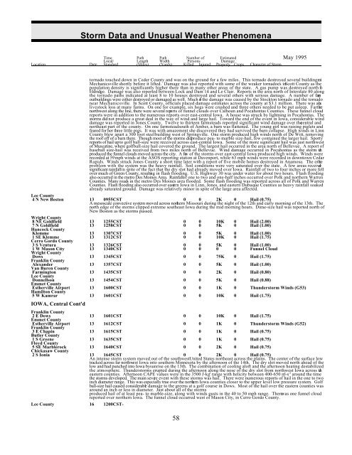
Time Path Path Number of Estimated May 1995<br />
Local/ Length Width Persons Damage<br />
Location Date St<strong>and</strong>ard (Miles) (Yards) Killed Injured Property Crops Character of <strong>Storm</strong><br />
tornado touched down in Ceder County <strong>and</strong> was on the ground for a few miles. This tornado destroyed several buildings ni<br />
Mechanicsville shortly before it lifted. Damage was also reported with some of the weaker tornadoes in Scott County as the<br />
population density is significantly higher there than in many other areas of the state. A gas pump was destroyed north of<br />
Eldridge. Damage was also reported between Lock <strong>and</strong> Dam 14 <strong>and</strong> Le Clair. Reports in the area north of Interstate 80 along<br />
the tornado paths indicated at least 8 to 10 houses destroyed <strong>and</strong> several others with serious damage. A number of farm<br />
outbuildings were either destroyed or damaged as well. Much of the damage was caused by the Stockton tornado <strong>and</strong> the tornado<br />
near Mechanicsville. In Scott County, officials placed damage estimates across the county at $3.1 million. There was also<br />
livestock loss at many farms. On one for example, six hogs were crushed <strong>and</strong> three others needed to be put asleep. Farthe r<br />
northwest along the line, there were several reports of funnel clouds over Calhoun <strong>and</strong> Pocahontas Counties. These funnel cloud<br />
reports were in addition to the numerous reports over east-central Iowa. A house was struck by lightning in Pocahontas. The<br />
storms did not produce a great deal in the way of wind <strong>and</strong> large hail. Toward the end of the event in Iowa, considerable wind<br />
damage was reported in Jones County. Twelve to thirteen farmsteads reported significant wind damage over the central <strong>and</strong><br />
northeast part of the county. On one farmstead south of Amber, a barn was flattened. The young girl was raising piglets <strong>and</strong><br />
feared for her three little pigs. It was with amazement she discovered they had survived the barn collapse. High winds in Linn<br />
County blew apart a 300 foot steel building west of Springville. One storm produced high winds north of De Witt, removing<br />
the roof off of a barn there. Though most of the storms did produce pea- to marble size-hail, few contained the larger hail. Spotty<br />
reports of hail up to golf ball-size were received across east-central Iowa. Some of the more significant hail was just northwest<br />
of Muscatine, where golf ball-size hail covered the ground. The largest hail occurred in the area north of Bellevue. A report of<br />
baseball size-hail was received from two miles north of Bellevue. Wind damage occurred in Pocahontas as the storm the<br />
produced the funnel clouds moved across the city. A few of the storms over east-central Iowa produced high winds. Winds were<br />
recorded at 59 mph winds at the ASOS reporting station at Davenport, while 63 mph winds were recorded in downtown Cedar<br />
Rapids. Winds struck Jones County a short time later with a report of five mobile homes destroyed in Anamosa. The othe r<br />
problem with the system was the heavy rainfall. Soil conditions were very saturated over the state. A few areas received<br />
significant rainfall in spite of the fact that the dry slot had already moved over Iowa. Rainfall of two to four inches or more fell<br />
over much of Green County, resulting in flash flooding. U.S. Highway 30 was under water for about two hours. Flash flooding<br />
also occurred in the metro Des Moines Area. Rainfallof one to two <strong>and</strong> one-half inches occurred over Polk <strong>and</strong> northern Warren<br />
Counties. Many roads in the metro Des Moines area flooded. Some flash flooding was reported across all of Polk <strong>and</strong> Warren<br />
Counties. Flash flooding also occurred over eastern Iowa in Linn, Jones, <strong>and</strong> eastern Dubuque Counties as heavy rainfall soaked<br />
already saturated ground. Damage was relatively minor in spite of the large area affected.<br />
Lee County<br />
4 N New Boston 13 0955CST 0 0 2K 0 Hail (0.75)<br />
A mesoscale convective system moved across northern Missouri during the night of the 12th <strong>and</strong> early morning of the 13th. The<br />
north edge of the storms clipped extreme southeast Iowa during the mid morning hours. Dime-size hail was reported north of<br />
New Boston as the storms passed.<br />
Wright County<br />
8 NE Goldfield 13 1255CST 0 0 10K 0 Hail (2.00)<br />
7 N Goldfield 13 1258CST 0 0 5K 0 Hail (1.00)<br />
Hancock County<br />
Klemme 13 1307CST 0 0 5K 0 Hail (1.00)<br />
1 SE Klemme 13 1312CST 0 0 10K 0 Hail (1.75)<br />
Cerro Gordo County<br />
3 S Ventura 13 1326CST 0 0 5K 0 Hail (1.00)<br />
1 W Mason City 13 1340CST 0 0 0 0 Funnel Cloud<br />
Wright County<br />
Dows 13 1345CST 0 0 75K 0 Hail (1.75)<br />
Franklin County<br />
Alex<strong>and</strong>er 13 1357CST 0 0 5K 0 Hail (1.00)<br />
Van Buren County<br />
Farmington 13 1435CST 0 0 2K 0 Hail (0.80)<br />
Lee County<br />
Donnellson 13 1454CST 0 0 5K 0 Hail (0.88)<br />
Emmet County<br />
Estherville Airport 13 1600CST 0 0 1K 0 Thunderstorm Winds (G53)<br />
Hamilton County<br />
5 W Kamrar 13 1601CST 0 0 10K 0 Hail (1.75)<br />
IOWA, Central Cont'd<br />
Franklin County<br />
2 E Dows 13 1601CST 0 0 10K 0 Hail (1.75)<br />
Emmet County<br />
Estherville Airport 13 1612CST 0 0 1K 0 Thunderstorm Winds (G52)<br />
Franklin County<br />
3 E Chapin 13 1615CST 0 0 1K 0 Hail (0.75)<br />
Butler County<br />
1 S Greene 13 1635CST 0 0 1K 0 Hail (0.75)<br />
Floyd County<br />
5 SE Marblerock 13 1640CST 0 0 2K 0 Hail (0.75)<br />
Chickasaw County<br />
2 S Ionia 13 1645CST 0 0 2K 0 Hail (0.75)<br />
An intense storm system moved out of the southwest United States northeast across the plains. The center of the surface low<br />
tracked across far northwest Iowa into southern Minnesota by the afternoon of the 14th. The dry slot moved north ahead of the<br />
low <strong>and</strong> had punched into Iowa by sunrise on the 13th. The combination of cooling aloft <strong>and</strong> the afternoon heating destabilized<br />
the atmosphere. Thunderstorms erupted during the afternoon along the nose of the dry slot from northwest Iowa across the<br />
-1 2 -2<br />
eastern counties. Afternoon CAPE values were in the 3500 J-kg range with helicity between 400-650 m-s around the time<br />
the storms developed. The main severe event with these storms was hail. There were numerous reports of hail in the one to two<br />
inch diameter range. This was especially true over the northern Iowa counties closer to the upper level low pressure system. Golf<br />
ball-size hail caused considerable damage to the greens at a golf course in Dows. Most of the hail over the eastern counties was<br />
around an inch or less in diameter. Just about all of the storms<br />
produced hail of at least pea- to marble-size, along with winds gusts in the 40 to 50 mph range. There was one funnel cloud<br />
reported over northern Iowa. The funnel cloud occurred west of Mason City, in Cerro Gordo County.<br />
Lee County 16 1200CST-<br />
58


