

Storm Data and Unusual Weather Phenomena - CIG
Storm Data and Unusual Weather Phenomena - CIG
Storm Data and Unusual Weather Phenomena - CIG

You also want an ePaper? Increase the reach of your titles
YUMPU automatically turns print PDFs into web optimized ePapers that Google loves.
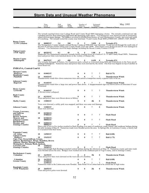
<strong>Storm</strong> <strong>Data</strong> <strong>and</strong> <strong>Unusual</strong> <strong>Weather</strong> <strong>Phenomena</strong><br />
Time Path Path Number of Estimated May 1995<br />
Local/ Length Width Persons Damage<br />
Location Date St<strong>and</strong>ard (Miles) (Yards) Killed Injured Property Crops Character of <strong>Storm</strong><br />
The tornado touched down near Ladoga Road <strong>and</strong> County Road 400S damaging a home. The tornado continued east nea r<br />
Linnsburg <strong>and</strong> New Ross destroying eight homes <strong>and</strong> damaging eight others. Two businesses were destroyed <strong>and</strong> an elementary<br />
school received major damage. The fatalities occurred in prefabricated homes of rural Montgomery County, just west <strong>and</strong> south<br />
of Linnsburg. The tornado exited the county near Interstate 74 <strong>and</strong> County Road 400S at 0008 EST. (M42P, F36P, M94P)<br />
Boone County<br />
12 SW Lebanon 14 0008EST 5.0 200 0 5 2.0M 0 Tornado (F2)<br />
The Montgomery County tornado entered Boone County at 0008 EST near Interstate 74 <strong>and</strong> moved through the south side of<br />
the town of Advance before lifting near County Roads 325S <strong>and</strong> 700W. Nine homes were destroyed <strong>and</strong> 28 were damaged in<br />
Advance. Two businesses received major damage including the Boone County Frontier CO-OP.<br />
Tipton County<br />
5 NW Tipton 14 0025EST 0.1 40 0 0 1.0K 0 Tornado (F0)<br />
Sharpsville Fire Department reported a tornado briefly touched down in a field at U.S. 31 <strong>and</strong> County Road 300N. Numerous<br />
trees <strong>and</strong> power lines were knocked down in the vicinity of Sharpsville.<br />
Marion County<br />
Indianapolis 14 0047EST 6.5 400 0 0 0.4M 0 Tornado (F2)<br />
The tornado damaged 30 homes, five businesses <strong>and</strong> a school as it traveled along 86th <strong>and</strong> 82nd streets in the Nora area of<br />
northeast Indianapolis. Numerous trees <strong>and</strong> power lines were downed by the storm. One boat was flipped on top of another at<br />
Geist Reservoir.<br />
INDIANA, Central Cont'd<br />
Morgan County<br />
Monrovia 14 0100EST 0 0 ? ? Hail (0.75)<br />
Hendricks County<br />
Plainfield 14 0102EST 0 0 ? ? Thunderstorm Winds<br />
Thunderstorm winds blew down numerous trees <strong>and</strong> carried a trampoline nearly a quarter mile in the air.<br />
Johnson County<br />
Hopewell 14 0144EST 0 0 ? ? Thunderstorm Winds<br />
Thunderstorm winds blew a large tree <strong>and</strong> power lines down. A large permanent sign was blown down on Interstate 65 near<br />
Whitel<strong>and</strong>.<br />
Henry County<br />
Lewisville 14 0146EST<br />
A 90-foot tower collapsed.<br />
0 0 ? ? Thunderstorm Winds<br />
Rush County<br />
Milroy 14 0233EST 0<br />
Trees <strong>and</strong> power lines were blown down in Milroy.<br />
0 ? ? Thunderstorm Winds<br />
Shelby County 16 1100EST 0 0 4K 0 Thunderstorm Winds<br />
Trees were downed, a utility pole was snapped, <strong>and</strong> there was some roof damage.<br />
Johnson County 16 1100EST<br />
Trees were downed.<br />
0 0 ? 0 Thunderstorm Winds<br />
Greene, Lawrence,<br />
<strong>and</strong> Sullivan 18 0230EST-<br />
Counties 0700EST 0 0 ? ? Flash Flood<br />
Brown, Jackson,<br />
Monroe, <strong>and</strong> 18 0330EST-<br />
Johnson Counties 0800EST 0 0 ? ? Flash Flood<br />
Bartholomew,<br />
Decatur, <strong>and</strong> 18 0400EST-<br />
Jennings Counties 0800EST 0 0 ? ? Flash Flood<br />
Heavy rain of two to five inches resulted in flash flooding over parts of southwest, south central, <strong>and</strong> southeast Indiana during<br />
the early morning of May 18. Numerous roads were flooded across the area. In Springville, in Lawrence County, a family had<br />
to evacuated from their home.<br />
Fountain County<br />
Mulberry 18 1543EST 0 0 ? ? Hail (1.75)<br />
Vigo, Clay, Owen,Sullivan, Greene,<br />
Monroe, Bartholomew, Boone, Hamilton, Brown<br />
Johnson, Marion, Morgan, Fountain,<br />
Montgomery, Putnam, Rush, Jackson,<br />
Lawrence <strong>and</strong> 18 1545EST-<br />
Jennings Counties 1830EST 0 0 ? ? Flash Flood<br />
Heavy rain brought flash flooding to muchof central Indiana during the afternoon of May 18. Numerous county <strong>and</strong> state roads<br />
were flooded across the area. Bridges were washed out in the southeast part of Vigo County, <strong>and</strong> in Jennings County.<br />
4 E Attica<br />
Clinton County<br />
18 1450EST 0 0 ? ? Hail (0.88)<br />
Bartholomew County<br />
Columbus<br />
lines were downed on the west of<br />
24<br />
Trees<br />
1615EST<br />
<strong>and</strong> power<br />
0<br />
side<br />
0<br />
Columbus.<br />
3K 0 Thunderstorm Winds<br />
Columbus 24 1615EST 0 0 ? ? Hail (0.88)<br />
Greene County 27 2130EST-<br />
2230EST 0 0 ? ? Flash Flood<br />
Numerous roads in the Linton area were flooded. State Road 54 in Linton had to be closed due to high water.<br />
R<strong>and</strong>olph County<br />
5 NW Winchester<br />
poles were downed.<br />
28<br />
Trees<br />
2045EST<br />
<strong>and</strong> power<br />
0 0 2K 0 Thunderstorm Winds<br />
52


