Storm Data and Unusual Weather Phenomena - CIG
Storm Data and Unusual Weather Phenomena - CIG
Storm Data and Unusual Weather Phenomena - CIG
You also want an ePaper? Increase the reach of your titles
YUMPU automatically turns print PDFs into web optimized ePapers that Google loves.
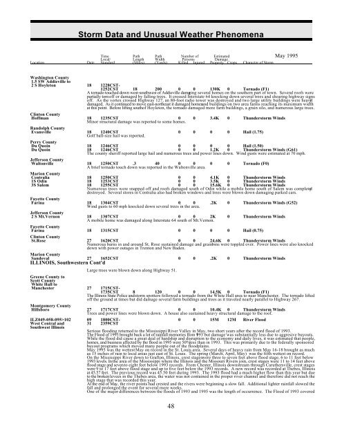
<strong>Storm</strong> <strong>Data</strong> <strong>and</strong> <strong>Unusual</strong> <strong>Weather</strong> <strong>Phenomena</strong><br />
Time Path Path Number of Estimated May 1995<br />
Local/ Length Width Persons Damage<br />
Location Date St<strong>and</strong>ard (Miles) (Yards) Killed Injured Property Crops Character of <strong>Storm</strong><br />
Washington County<br />
1.5 SW Addieville to<br />
2 S Hoyleton 18 1228CST-<br />
1252CST 18 200 0 0 130K 0 Tornado (F1)<br />
A tornado touched down west-southwest of Addieville damaging several homes on the southern part of town. Several roofs were<br />
partially torn off or damaged by falling trees. It crossed Interstate 64 knocking down several trees <strong>and</strong> shearing highway signs<br />
off. As the vortex crossed Highway 127, an 80-foot radio tower was destroyed <strong>and</strong> two large utility buildings were heavil y<br />
damaged. As it continued to move east-northeast it damaged homes<strong>and</strong> buildings on two area farms reaching its maximum width<br />
at this point. Before lifting south of Hoyleton, the tornado damaged more farm buildings, a grain silo, <strong>and</strong> numerous large trees.<br />
Clinton County<br />
Hoffman 18 1235CST 0<br />
Minor structural damage was reported to some homes.<br />
0 3.4K 0 Thunderstorm Winds<br />
R<strong>and</strong>olph County<br />
Evansville 18 1240CST<br />
Golf ball-size hail was reported.<br />
0 0 0 0 Hail (1.75)<br />
Perry County<br />
Du Quoin 18 1246CST 0 0 0 0 Hail (1.50)<br />
Du Quoin 18 1246CST 0 0 1.2K 0 Thunderstorm Winds (G61)<br />
The county sheriff reported large hail <strong>and</strong> numerous trees <strong>and</strong> power lines down. Wind gusts were estimated at 70 mph.<br />
Jefferson County<br />
Waltonville<br />
was in the area.<br />
18<br />
A brief<br />
1250CST<br />
tornado touch<br />
.3<br />
down<br />
40<br />
reported<br />
0<br />
Waltonville<br />
0 0 0 Tornado (F0)<br />
Marion County<br />
Centralia 18 1250CST 0 0 4.1K 0 Thunderstorm Winds<br />
1S Odin 18 1253CST 0 0 3.5K 0 Thunderstorm Winds<br />
3S Salem 18 1255CST 0 0 15.6K 0 Thunderstorm Winds<br />
Numerous trees were snapped off <strong>and</strong> roofs damaged south of Odin while a mobile home south of Salem was completel y<br />
destroyed. Several stores in Centralia also had broken windows <strong>and</strong> trees were blown down damaging parked cars.<br />
Fayette County<br />
Farina<br />
mph knocked down several the<br />
18<br />
Wind<br />
1304CST<br />
gusts to 60<br />
0<br />
trees in<br />
0<br />
area.<br />
.2K 0 Thunderstorm Winds (G52)<br />
Jefferson County<br />
2 S Mt.Vernon 18 1307CST 0 0 2K<br />
A mobile home was damaged along Interstate 64 south of Mt.Vernon.<br />
0 Thunderstorm Winds<br />
Fayette County<br />
Farina 18 1315CST 0 0 0 0 Hail (0.75)<br />
Clinton County<br />
St.Rose 27 1620CST 0 0 24.6K 0 Thunderstorm Winds<br />
Numerous barns in <strong>and</strong> around St. Rose sustained damage <strong>and</strong> grain bins were toppled over. Power lines were also knocked<br />
down with power outages in Trenton <strong>and</strong> New Baden.<br />
Marion County<br />
S<strong>and</strong>oval<br />
ILLINOIS, Southwestern<br />
27<br />
Cont'd<br />
1652CST 0 0 .2K 0 Thunderstorm Winds<br />
Large trees were blown down along Highway 51.<br />
Greene County to<br />
Scott County<br />
White Hall to<br />
Manchester 27 1715CST-<br />
1735CST 8 120 0 0 14.5K 0 Tornado (F1)<br />
The Illinois State Police <strong>and</strong> storm spotters followed a tornado from the White Hall area to near Manchester. The tornado lifted<br />
off the ground at times but did damage several farm buildings <strong>and</strong> trees as it traveled nearly parallel to Highway 267.<br />
Montgomery County<br />
Hillsboro 27 1717CST 0 0 10.4K 0 Thunderstorm Winds<br />
Trees <strong>and</strong> power lines were blown down. A house also sustained heavy structural damage to the roof.<br />
ILZ049-058-095>102 09 1800CST- 0 0 15M 12M River Flood<br />
West Central <strong>and</strong> 31 2359CST<br />
Southwest Illinois<br />
Serious flooding returned to the Mississippi River Valley in May, two short years after the record flood of 1993.<br />
The Flood of 1995 brought back a lot of rainfall memories from 1993 but damage was substantially less due to aggresive buyouts.<br />
While the flood did cause a great deal of hardship <strong>and</strong> disruption to the economy <strong>and</strong> daily lives, it was estimated that people,<br />
homes, <strong>and</strong> business affected by the flood in 1995 were 50%less than in 1993. This was primarily due to the federally sponsored<br />
buyout programs which moved many people out of the floodplains.<br />
May 1995 was the wettest May on record in the St. Louis area. Several days of heavy rain from May 16-18 brought as much<br />
as 15 inches of rain to local areas just east of St. Louis. The spring (March, April, May) was the fifth wettest on record.<br />
On the Mississippi River down to Grafton, Illinois, crest stages were three to seven feet above flood stage, 6 to 11 feet below<br />
1993 levels. In the area of the Mississippi where the Illinois <strong>and</strong> the Missouri Rivers join, crest stages were 11 to 14 feet above<br />
flood stage <strong>and</strong> seven to eight feet below 1993 records. From Chester, Illinois downstream through Caruthersville, crest stages<br />
were 9 to 17 feet above flood stage <strong>and</strong> up to five feet below the 1993 records. A new record was recorded at Thebes, Illinois<br />
at 45.57 feet. The previous record was 45.50 feet during 1993. The 1993 flood had a much higher flow than this year but due<br />
to the broken levees in the Thebes area, the water was not contained in the proper river channel <strong>and</strong> therefore did not reach the<br />
high stage that was recorded this year.<br />
At the end of May, the river points had crested <strong>and</strong> the rivers were beginning a slow fall. Additional lighter rainfall slowed the<br />
fall <strong>and</strong> prolonged the event for several more weeks.<br />
One of the major differences between the floods of 1993 <strong>and</strong> 1995 was the length of occurrence. The Flood of 1993 covered<br />
48


