

Storm Data and Unusual Weather Phenomena - CIG
Storm Data and Unusual Weather Phenomena - CIG
Storm Data and Unusual Weather Phenomena - CIG

Create successful ePaper yourself
Turn your PDF publications into a flip-book with our unique Google optimized e-Paper software.
<strong>Storm</strong> <strong>Data</strong> <strong>and</strong> <strong>Unusual</strong> <strong>Weather</strong> <strong>Phenomena</strong><br />
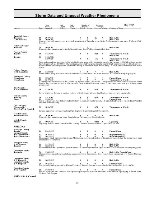
Time Path Path Number of Estimated May 1995<br />
Local/ Length Width Persons Damage<br />
Location Date St<strong>and</strong>ard (Miles) (Yards) Killed Injured Property Crops Character of <strong>Storm</strong><br />
R<strong>and</strong>olph County<br />
Roanoke 18 2040CST ? ? 2k 0 Hail (1.00)<br />
7 NE Roanoke 18 2040CST ? ? ? ? Hail (1.00)<br />
Quarter-size hail was reported seven miles northeast of Roanoke at the Springfield community <strong>and</strong> along Highway 87 ni<br />
Roanoke.<br />
Jefferson County<br />
Fairfield 25 1655CST ? ? ? ? Hail (0.75)<br />
Dime-size hail was reported by the Jefferson County Sheriff's Department at Fairfield.<br />
Fayette County<br />
Fayette 28 1122CST 0 0 0.2k 0 Thunderstorm Winds<br />
Hail (0.75)<br />
Fayette 28 1130CST-<br />
1150CST 0 0 18k 0 Thunderstorm Winds<br />
Hail (1.00)<br />
Trees <strong>and</strong> power lines were downed by wind in Fayette along with reports of dime-size hail around 1122 CST <strong>and</strong> quarter-size<br />
hail between 1130 <strong>and</strong> 1150 CST. The worst damage reported was at the Fayette County High School where two bleachers were<br />
blown off their concrete pads <strong>and</strong> twisted into a heap of aluminum about 50 feet away. A chain link backstop was also blown<br />
down.<br />
Pickens County<br />
4 NE Carrollton 28 1130CST ? ? ? ? Hail (0.75)<br />
Dime -ze hail along with small hail was reported at Stansel about four miles northeast of Carrollton along Highway 17.<br />
Tuscaloosa County<br />
Tuscaloosa 28 1220CST ? ? ? ? Funnel Cloud<br />
Tuscaloosa 28 1240CST ? ? ? ? Thunderstorm Winds<br />
A funnel cloud was reported in the Queen City Avenue area of Tuscaloosa. Thunderstorm wind also downed trees <strong>and</strong> power<br />
lines in the city with reports of at least one store front window blown out. About 2,300 power customers were without power<br />
at one point.<br />
Bibb County<br />
5 W Centreville 28 1338CST 0 0 0.2k 0 Thunderstorm Winds<br />
Power lines were downed in western sections of Bibb County along with at least one power pole in Centreville.<br />
Sumter County<br />
Bellamy 28 1347CST 0 0 0.2k 0 Thunderstorm Winds<br />
Ward 28 1350CST ? ? ? ? Funnel Cloud<br />
Ten to 12 trees were reported downed in Bellamy in southern Sumter County. A funnel cloud was also reported near Ward in<br />
southern Sumter County.<br />
Clarke County<br />
Thomasville 28 1810CST 0 0 0.5k 0 Thunderstorm Winds<br />
ALABAMA Cont'd<br />
Several trees were blown down along State Highway 5 just northeast of Thomasville.<br />
Mobile County<br />
Dauphin Isl<strong>and</strong> 29 2030CST 0 0 0 0 Hail (0.75)<br />
Dime-size hail was reported along Daupin Isl<strong>and</strong> Parkway near Dauphin Isl<strong>and</strong>.<br />
Mobile County<br />
Mobile 30 1005CST 0 0 0.1M 0 Lightning<br />
Lightning struck a house in west Mobile causing a fire that destroyed about 75 percent of the roof.<br />
ARIZONA<br />
Maricopa County<br />
Peoria 06 2244MST 0 0 0 0 Funnel Cloud<br />
Yavapai County<br />
Lake Montezuma 12 1620MST 0 0 0 0 High Winds (G61)<br />
Lake Montezuma 13 1043MST 0 0 0 0 High Winds (G57)<br />
Strong, gusty winds were reported at Lake Montezuma. Location of spotter within canyon suggests that the strong winds were<br />
enhanced by local terrain.<br />
Yavapai County<br />
2 SW Prescott 16 1515MST 0 0 0 0 Hail (0.75)<br />
Prescott 16 1525MST 0 0 0 0 Hail (0.75)<br />
Several reports of hail up to three-quarters inches. A spotter reported hail up to one-half inch in diameter covering the ground.<br />
Coconino County<br />
Fredonia 26 1500MST 0 0 0 0 Hail (1.00), Funnel Cloud<br />
Thunderstorm produced one inch hail <strong>and</strong> accumulated two to three inches. Brief funnel cloud was spotted over Kaibab National<br />
Forest.<br />
Coconino County<br />
1 W Flagstaff 26 1605MST 0 0 0 0 Hail (0.80)<br />
Coconino County<br />
5 W Flagstaff 26 1615MST 0 0 0 0 Funnel Clouds<br />
Two funnel clouds witnessed by Flagstaff National <strong>Weather</strong> Service personnel at Bellemont <strong>Weather</strong> Service Office.<br />
Coconino County<br />
8 SE Flagstaff 26 1710MST 0 0 0 0 Funnel Cloud<br />
Funnel cloud one mile southeast of Flagstaff airport spotted by tower personnel. Simultaneous sighting by Walnut Canyon<br />
National Park Ranger.<br />
ARKANSAS, Central<br />
14


