

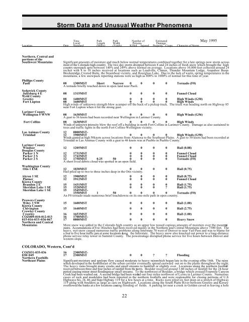
Storm Data and Unusual Weather Phenomena - CIG
Storm Data and Unusual Weather Phenomena - CIG
Storm Data and Unusual Weather Phenomena - CIG

Create successful ePaper yourself
Turn your PDF publications into a flip-book with our unique Google optimized e-Paper software.
<strong>Storm</strong> <strong>Data</strong> <strong>and</strong> <strong>Unusual</strong> <strong>Weather</strong> <strong>Phenomena</strong><br />
Time Path Path Number of Estimated May 1995<br />
Local/ Length Width Persons Damage<br />
Location Date St<strong>and</strong>ard (Miles) (Yards) Killed Injured Property Crops Character of <strong>Storm</strong><br />
Northern, Central <strong>and</strong><br />
portions of the<br />
Southwest Mountains<br />
Significant amounts of moisture <strong>and</strong> much below normal temperatures combined together for a late springs now storm across<br />
most of the Colorado high country. The two day storm dropped between 8 <strong>and</strong> 24 inches of fresh snow which brought the high<br />
country snowpack up to between 140% <strong>and</strong> 249% above normal on average. Locations above 10,800 feet collected around 24<br />
inches with 8 to 18 inches received at locations such as Leadville, Climax, Thunder Mountain Lodge, Arapahoe Basin ,<br />
Breckenridge, Crested Butte, the Steamboat vicinity, <strong>and</strong> Hourglass Lake. Due to the lack of warm, spring temperatures in the<br />
mountains, a few snowpack reporting stations were as high as 800% to 1000% of normal for this time of year.<br />
Phillips County<br />
Paoli 08 1300MST Short Narrow 0<br />
A tornado briefly touched down in open l<strong>and</strong> near Paoli.<br />
0 0 0 Tornado (F0)<br />
Sedgwick County<br />
Julesburg 4 E 08 1315MST 0 0 0 0 Funnel Cloud<br />
Weld County<br />
Greeley 08 1400MST 0 0 0 0 High Winds (G50)<br />
Fort Lupton 08 1600MST 0 0 0 0 High Winds<br />
High winds of unknown strength blew a camper off the back of a pickup truck. The truck was heading north on Highway 85<br />
near Fort Lupton when it hit the strong gust.<br />
Larimer County<br />
Wellington 5 WNW 08 1630MST 0 0 0<br />
A gust to 56 knots had been recorded near Wellington in Larimer County.<br />
0 High Winds (G56)<br />
Fort Collins 08 1630MST 0 0 0 0 High Winds<br />
Winds of unknown intensity blew the roof off a building in north Fort Collins in Larimer County. Damage as also sustained to<br />
trees <strong>and</strong> traffic lights in the north Fort Collins-Wellington vicinity.<br />
Las Animas County 12 0800MST-<br />
Trinidad 12 1900MST 0 0 0 0 High Winds (G50)<br />
Winds gusted as high 50 knots across locations from Alamosa to the Southeast Plains. A gust to 50 knots had been recorded at<br />
Trinidad in Las Animas County with a gust to 46 knots was at Pueblo in Pueblo County.<br />
Larimer County<br />
Parker 1 N 12 1731MST 0 0 0 0 Funnel Cloud<br />
Parker 2 S 12 1742MST 0 0 0 0 Funnel Cloud<br />
Parker 2 S 12 1750MST 0.25 50 0 0 0 0 Tornado (F0)<br />
A short lived debris cloud was spotted in an open field.<br />
Windsor<br />
Douglas County<br />
12 1205MST 0 0 0 0 Hail (0.88)<br />
Washington County<br />
Otis 1 ESE 12 1830MST 0 0<br />
Hail piled up to two to three inches deep in the Otis vicinity.<br />
0 0 Hail (0.75)<br />
Akron 1 SE 12 1900MST 0 0 0 0 Hail (0.75)<br />
Platner 12 1912MST 0 0 0 0 Funnel Cloud<br />
Kiowa County<br />
Br<strong>and</strong>on 2 E 15 1431MST 0 0 0 0 Hail (1.75)<br />
Sheridan Lake 1 SE 15 1520MST 0 0 0 ? Hail (1.75)<br />
Sheridan Lake 1 SE 15 1545MST-<br />
1550MST 1 50 0 0 0 0 Tornado (F0)<br />
An F0 tornado made numerous brief touchdowns on its one-mile path in open country.<br />
Prowers County<br />
Chivington 15 1640MST 0 0 0 0 Hail (2.75)<br />
Crowley County<br />
Crowley 16 1653MST 0 0 0 0 Hail (1.00)<br />
COZ009-010-012-013 16 1700MST-<br />
015-016-033>036-067 17 0800MST 0 0 0 0 Heavy Snow<br />
Wiley 3 NW<br />
Kiowa County<br />
15 1600MST 0 0 0 0 Hail (1.00)<br />
Northern <strong>and</strong> Central<br />
Mountains<br />
COLORADO, Western, Cont'd<br />
More snow was added to the Colorado high country as an upper low tossed copious amounts of moisture over the mountai n<br />
states. Accumulations of 8 to 18 inches had been received mainly in the Northern <strong>and</strong> Central Mountains above 7500 feet. The<br />
heavy, wet snow caused numerous traffic problems along Interstate 70 west of Denver to near Vail Pass <strong>and</strong> was to blame for<br />
a four to five hour traffic jam at some locations along the Interstate. The heavy snow also knocked out power to a long-distance<br />
phone service relay tower in Summit County. The power outage disrupted phone service for five hours between Denver <strong>and</strong><br />
western slope.<br />
COZ031-035-036 16 2300MST-<br />
038>045 17 2300MST 0 0 ? ? Flooding<br />
Northern Foothills<br />
Northeast Plains<br />
Significant moisture <strong>and</strong> upslope flow caused moderate to heavy rains which began late in the evening ofthe 16th. The rains<br />
which developed in the foothills east of the urban corridor eventually spread eastward out on to the plains throughout the night.<br />
The heavy rains brought many creeks <strong>and</strong> small streams to bankfull or slightly over. Locations along the northern foothill s<br />
received between three <strong>and</strong> four inches of rainfall from the storm. Boulder received around 3.60 inches of rainfall for the 24-hour<br />
period causing minor street flooding near small streams. To the northwest of Boulder, a bridge which crossed Fourmile Canyon<br />
Creek had been washed out. A second bridge had been washed out four miles northwest of Lyons in Larimer County. Numerous<br />
cases of rock <strong>and</strong> mudslides had been reported in the northern foothills <strong>and</strong> were responsible for closing portions of U.S .<br />
Highways Six, 24, 40, <strong>and</strong> State Highway 119 for a few hours at a time. Rocks were piled six feet deep on a stretch of Highway<br />
119 along with boulders as large as cars on Highway 6. Locations along the South Platte River between Greeley <strong>and</strong> Kersey<br />
overflowed the banks at a few locations causing flooding of fields. A parking lot near a creek in Golden caved in leaving a hole<br />
22


