

Storm Data and Unusual Weather Phenomena - CIG
Storm Data and Unusual Weather Phenomena - CIG
Storm Data and Unusual Weather Phenomena - CIG

Create successful ePaper yourself
Turn your PDF publications into a flip-book with our unique Google optimized e-Paper software.
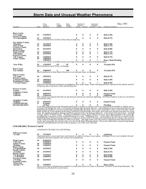
<strong>Storm</strong> <strong>Data</strong> <strong>and</strong> <strong>Unusual</strong> <strong>Weather</strong> <strong>Phenomena</strong><br />
Time Path Path Number of Estimated May 1995<br />
Local/ Length Width Persons Damage<br />
Location Date St<strong>and</strong>ard (Miles) (Yards) Killed Injured Property Crops Character of <strong>Storm</strong><br />
Baca County<br />
4 S Campo 22 1530MST 0 0 0 0 Hail (1.00)<br />
Prowers County<br />
10 S Springfield 22 1555MST 0 0 0 0 Hail (0.75)<br />
Hail accumulated two to three inches deep on highway.<br />
Las Animas County<br />
Crowley County<br />
Rockyford 22 2014MST 0 0 0 0 Hail (0.88)<br />
Kiowa County<br />
Eads 10 ENE 22 2204MST 0 0 0 ? Hail (1.75)<br />
Chivington 22 2215MST 0 0 0 ? Hail (2.75)<br />
Prowers County<br />
4 W Lamar 26 1250MST 0 0 0 0 Hail (0.75)<br />
Wiley Vicinity 26 1300MST-<br />
1700MST 0 0 0 ? Heavy Rain/Flooding<br />
Two to four inches of rainfall caused some high creek levels <strong>and</strong> minor lowl<strong>and</strong> flooding.<br />
Thatcher<br />
Kim, E Kim<br />
22<br />
22<br />
1612MST<br />
1630MST<br />
0<br />
0<br />
0<br />
0<br />
0<br />
0<br />
0<br />
?<br />
Hail (1.00)<br />
Hail (1.75)<br />
Near Wiley 26 1345MST 0.5 50<br />
Brief touchdown near Wiley, no damage.<br />
0 0 0 0 Tornado (F0)<br />
Bent County<br />
Las Animas 26 1500MST 1 100 0 0 0<br />
Brief touchdown at John Martin Reservoir over l<strong>and</strong> <strong>and</strong> water, no damage.<br />
0 Tornado (F0)<br />
Elbert County<br />
2 N Agate 26 1505MST 0 0 0 0 Hail (0.75)<br />
El Paso County<br />
Colorado Springs 26 1505MST 0 0 0 0 Hail (1.00)<br />
Washington County 26 1520MST-<br />
7 S Last Chance 1540MST 0 0 0 ? Hail (0.50)<br />
Hail up to a one-half inch in diameter accumulated to four inches deep. Minor flooding had been reported in the ditches <strong>and</strong> low<br />
lying areas due to the heavy rains <strong>and</strong> melting hail.<br />
Prowers County<br />
Littleton 26 1800MST 0 0 0 0 Funnel Cloud<br />
Littleton 26 Unknown ? 0 1 0 Lightning<br />
One woman was injured when the car she had just entered was struck by lightning. All of the windows in the car were blown<br />
out with the strike.<br />
Arapahoe County<br />
Watkins 27 1846MST 0 0 0 0 Funnel Cloud<br />
COZ035-038>041 27 Evening-<br />
043-044-048-04931 All Day 0 0 0 0 Flooding<br />
A wet May continued across the Mountains <strong>and</strong> Eastern Colorado as streams <strong>and</strong> rivers maintained at bankfull or slightly above.<br />
From the 27th through the 31th, a cool period including light morning showers <strong>and</strong> moderate to heavy afternoon showers <strong>and</strong><br />
thunderstorms, pushed river levels over the banks causing minor flooding. Rivers such as Boulder Creek, Cache la Poudre, South<br />
Platte, <strong>and</strong> the St. Vrain experienced flooding confined to meadowl<strong>and</strong>s, bike paths, <strong>and</strong> roads near streams <strong>and</strong> other low lying<br />
areas. No significant property damage had been reported with crop damage unknown. A few head of livestock had perished<br />
in high waters in Weld County. Flooding in Boulder County again washed out some major thoroughfares near Lyons <strong>and</strong><br />
prompted the evacuation of four residential blocks in Lyons. The highest river levels since 1983 arrived to a stretch of the<br />
South Platte River between Greeley to Kersey (Confluence of the Cache la Poudre <strong>and</strong> South Platte Rivers) along with a portion<br />
of the Cache la Poudre River from Fort Collins to Greeley. The high waters were the result of significant rains from the last two<br />
weeks <strong>and</strong> especially the last five days over the South Platte Drainage Basin. Due to the much below normal temperatures<br />
statewide <strong>and</strong> additional snowfall in the mountains, very little snow melt had<br />
Lamar<br />
Arapahoe County<br />
26 1615MST 0 0 0 0 Hail (1.00)<br />
COLORADO, Western Cont'd<br />
contributed to the high rivers <strong>and</strong> flooding.<br />
Jefferson County<br />
Arvada 29 1515MST 0 6 0 0 Lightning<br />
Lightning struck a soccer goal post <strong>and</strong> injured six adults viewing a soccer game. Although no one received a direct hit <strong>and</strong><br />
escaping with minor injuries, one woman was hospitalized.<br />
Weld County 30 0740MST-<br />
9 SE Erie 0750MST 0 0 0 0 Funnel Cloud<br />
Adams County 30 1320MST-<br />
Watkins 30 1328MST 0 0 0 0 Funnel Cloud<br />
Baca County<br />
2 S Springfield 30 1455MST 0 0 0 0 Hail (1.00)<br />
Pueblo County<br />
Avondale 30 1516MST 0 0 0 0 Hail (0.75)<br />
Kiowa County<br />
9 N Br<strong>and</strong>on 30 1530MST 0 0 0 0 Hail (0.88)<br />
7 N Br<strong>and</strong>on 30 1640MST 0 0 0 0 Hail (0.88)<br />
Prowers County<br />
2 N Wiley 30 1845MST 0 0 0 0 Funnel Cloud<br />
Garfield County<br />
Glenwood<br />
Springs 7 W 31 1520MST 0 0 0 0 Heavy Rain<br />
Heavy rain from a thunderstorm resulted in a mud slide across two lanes of Interstate 70 below <strong>Storm</strong> King Mountain. The<br />
interstate was blocked for several hours.<br />
24


