

Storm Data and Unusual Weather Phenomena - CIG
Storm Data and Unusual Weather Phenomena - CIG
Storm Data and Unusual Weather Phenomena - CIG

Create successful ePaper yourself
Turn your PDF publications into a flip-book with our unique Google optimized e-Paper software.
<strong>Storm</strong> <strong>Data</strong> <strong>and</strong> <strong>Unusual</strong> <strong>Weather</strong> <strong>Phenomena</strong><br />
Time Path Path Number of Estimated May 1995<br />
Local/ Length Width Persons Damage<br />
Location Date St<strong>and</strong>ard (Miles) (Yards) Killed Injured Property Crops Character of <strong>Storm</strong><br />
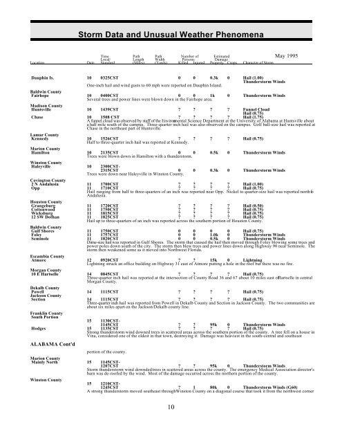
Dauphin Is. 10 0325CST 0 0 0.3k 0 Hail (1.00)<br />
Thunderstorm Winds<br />
One-inch hail <strong>and</strong> wind gusts to 60 mph were reported on Dauphin Isl<strong>and</strong>.<br />
Baldwin County<br />
Fairhope<br />
power lines were blown down<br />
10<br />
Several<br />
0400CST<br />
trees <strong>and</strong><br />
0<br />
in the<br />
0<br />
Fairhope<br />
1k<br />
area.<br />
0 Thunderstorm Winds<br />
Madison County<br />
Huntsville 10 1439CST ? ? ? ? Funnel Cloud<br />
Hail (0.75)<br />
Chase 10 1508 CST ? ? ? ? Hail (1.75)<br />
A funnel cloud was observed by staff of the Environmental Science Department at the University of Alabama at Huntsville about<br />
a half mile south of the campus. Three-quarter inch hail was also observed on the campus. Golf ball-size hail was reported at<br />
Chase in the northeast part of Huntsville.<br />
Lamar County<br />
Kennedy 10 1526CST ?<br />
Half to three-quarter inch hail was reported at Kennedy.<br />
? ? ? Hail (0.75)<br />
Marion County<br />
Hamilton 10 2135CST 0 0<br />
Trees were blown down in Hamilton with a thunderstorm.<br />
0.5k 0 Thunderstorm Winds<br />
Winston County<br />
Haleyville 10 2300CST-<br />
2315CST 0<br />
Trees were down near Haleyville in Winston County.<br />
0 0.3k 0 Thunderstorm Winds<br />
Covington County<br />
? ? ? Hail (1.00)<br />
? ? ? Hail (0.75)<br />
Hail ranging from half to three-quarters of an inch was reported near Opp. Nickel to quarter-size hail was reported north fo<br />
Andalusia.<br />
2 N Andalusia<br />
Opp<br />
11<br />
11<br />
1700CST<br />
1710CST<br />
?<br />
?<br />
Houston County<br />
Wicksburg 11 1815CST ? ? ? ? Hail (0.75)<br />
12 SW Dothan 11 1825CST ? ? ? ? Hail (0.75)<br />
Hail up to three-quarters of an inch was reported across the southern portion of Houston County.<br />
Grangeburg<br />
Cottonwood<br />
11<br />
11<br />
1720CST<br />
1750CST<br />
?<br />
?<br />
?<br />
?<br />
?<br />
?<br />
?<br />
?<br />
Hail (0.50)<br />
Hail (0.75)<br />
Baldwin County<br />
Winds<br />
Seminole 11 1820CST 0 0 0.5k 0 Thunderstorm Winds<br />
Dime-size hail was reported in Gulf Shores. The storm that caused the hail then moved through Foley blowing some trees <strong>and</strong><br />
power poles down south of the city. The storm then blew trees <strong>and</strong> power lines down along Highway 90 near Seminole. The<br />
storm then weakened some as it moved into Northwest Florida.<br />
Gulf Shores<br />
Foley<br />
11<br />
11<br />
1750CST<br />
1757CST<br />
0<br />
0<br />
0<br />
0<br />
0<br />
1.0k<br />
0<br />
0<br />
Hail (0.75)<br />
Thunderstorm<br />
Escambia County<br />
Atmore 12 0920CST ? ? 15k 0 Lightning<br />
Lightning struck an office building on Highway 31 east of Atmore putting a hole in the roof but there was no fire.<br />
Morgan County<br />
10 E Hartselle 14 0845CST ? ? ? ? Hail (0.75)<br />
Three-quarter inch hail was reported at the intersection of County Road 36 <strong>and</strong> 67 about 10 miles east of Hartselle in central<br />
Morgan County.<br />
Dekalb County<br />
Powell 14 1115CST ? ? ? ? Hail (0.75)<br />
Jackson County<br />
Section 14 1115CST ? ? ? ? Hail (0.75)<br />
Three-quarter inch hail was reported from Powell in Dekalb County <strong>and</strong> Section in Jackson County. The two communities are<br />
about six miles apart on the Jackson/Dekalb county line.<br />
Franklin County<br />
South Portion<br />
15 1130CST-<br />
1145CST ? ? 95k 0 Thunderstorm Winds<br />
Hodges 15 1135CST ? ? ? ? Hail (0.75)<br />
Strong thunderstorm wind downed trees in scattered areas across the southern portion of the county. A tree fell on a house in<br />
Vina, considered one of the oldest in that town, destroying it. Damage was heaviest in the south-central <strong>and</strong> southeast<br />
ALABAMA Cont'd<br />
portion of the county.<br />
Marion County<br />
Mainly North 15 1145CST-<br />
1207CST ? ? 95k 0 Thunderstorm Winds<br />
<strong>Storm</strong> thunderstorm wind downded trees in scattered areas across the county. The emergency Medical Association director's<br />
barn was de-roofed by the wind. Most of the damage occurred across the northern portion of the county.<br />
Winston County<br />
15 1210CST-<br />
1245CST ? 1 80k 0 Thunderstorm Winds (G60)<br />
A strong thunderstorm moved southeast through Winston County on a diagonal course that took it from the northwest corner<br />
10


