

Storm Data and Unusual Weather Phenomena - CIG
Storm Data and Unusual Weather Phenomena - CIG
Storm Data and Unusual Weather Phenomena - CIG

Create successful ePaper yourself
Turn your PDF publications into a flip-book with our unique Google optimized e-Paper software.
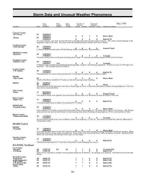
<strong>Storm</strong> <strong>Data</strong> <strong>and</strong> <strong>Unusual</strong> <strong>Weather</strong> <strong>Phenomena</strong><br />
Time Path Path Number of Estimated May 1995<br />
Local/ Length Width Persons Damage<br />
Location Date St<strong>and</strong>ard (Miles) (Yards) Killed Injured Property Crops Character of <strong>Storm</strong><br />
Canyon County<br />
10 S Nyssa 01 1445MST-<br />
1500MST 0 0 3 0 Heavy Rain<br />
Parma 01 1500MST-<br />
1530MST 0 0 0 0 Hail (0.75)<br />
In seven minutes, one inch of rain fell from a thunderstorm that moved south of Nyssa. The storm caused damage to the<br />
sugerbeet crops in the area. The same storm then produced three-fourths inch hail at Parma.<br />
Caribou County<br />
Soda Springs 03 1105MST-<br />
1108MST 0 0 0 0 Funnel Cloud<br />
A funnel cloud occured north of Soda Springs, Idaho, lasting only three minutes.<br />
Minidoka County<br />
Heyburn 04 1630MST-<br />
1700MST 0 0 3 0 Tornado<br />
Tornado touches down in Heyburn knocking down large TV antenna <strong>and</strong> lifting shinges off the roof of a house.<br />
Franklin County<br />
Station Creek 05 1400MST-<br />
1420MST 8 m 0 0 3 0 Tornado<br />
In Station Creek a tornado moved through destorying barns, campers <strong>and</strong> farming equipment. Winds in excess of 100 mph were<br />
reported. The tornado lasted 20 minutes.<br />
Cassia County<br />
5 W Oakley 05 1145MST-<br />
1215MST 0 0 0 0 Hail (0.75)<br />
Thunderstorms in Cassia county produced 0.75 inch-hail five miles west of Oakley, Idaho.<br />
IDZ001<br />
Ada County 05 0 0 0 0 Heavy Rain<br />
North of the Boise foothills 0.75 inches of rain fell causing minor flooding.<br />
IDZ011 06 1930PST-<br />
07 0900PST 0 0 2 0 Flood<br />
The South Fork of the Clearwater rises above flood stage in Lewis, Clearwater <strong>and</strong> Idaho Counties closing Highway 14 for two<br />
days due to mud <strong>and</strong> debris.<br />
Ada County<br />
Kuna 11 0835MST-<br />
0845MST 0 0 0 0 Funnel Cloud<br />
Two funnel clouds were spotted, one near Kuna <strong>and</strong> the other over Interstate 84 near the Black Creek exit.<br />
Boise County<br />
Idaho City 17 1500MST-<br />
1530MST 0 0 0 0 Hail (0.75)<br />
A strong thunderstorm in Idaho City produced 0.75 inches.<br />
IDZ002-003<br />
Pocatello-Eden 22 1230MST-<br />
1630MST 0 0 0 0 Heavy Rain<br />
In ten minutes, 0.38 inches of rain fell in Pocatello. Rain in the amount of 1.20 inches fell in Eden in 45 minutes. The Hansen<br />
area received one <strong>and</strong> one-half inches of rain causing some minor flooding closing highway 30 for a short period of time.<br />
Blaine County<br />
Timmerman Hills 26 1115MST-<br />
1145MST 0 0 0 0 Tornado<br />
Several funnel clouds were seen in Blaine county near highways 75 <strong>and</strong> 20. One funnel touched the earth for 30 seconds in<br />
Timmerman Hills.<br />
IDAHO Cont'd<br />
IDZ003<br />
Pocatello 31 1700MST-<br />
2000MST 0 0 7 0 Heavy Rain<br />
Two <strong>and</strong> one-half inches of rain fell in the Pocatello area in one hour causing flooding, mudslides, <strong>and</strong> power outages. Many<br />
basements <strong>and</strong> low-lying roads were affected. Some roads were closed <strong>and</strong> minor traffic accidents occurred. Raymond Park<br />
below the west bench was flooded with water two feet deep.<br />
Owyhee County<br />
Reynold Ck. 31 1630MST-<br />
1645MST 0 0 0 0 Hail (0.75)<br />
Thunderstorm produced 0.75 inch hail at Reynolds Creek damaging tree leaves.<br />
ILLINOIS, Northeast<br />
Lee County<br />
Harmon 09 1725CST 0.5 30 ? ? 0 0 Tornado (F0)<br />
2 E Dixon 09 1754CST ? ? 0 0 Hail (1.75)<br />
State Police reported a tornado on the ground southwest of Harmon. No damage was reported. Golf ball-size hail fell nea r<br />
Dixon.<br />
De Kalb County<br />
Somonauk 09 1810CST ? ? 0 0 Hail (0.75)<br />
2 NE Somonauk 09 1835CST ? ? 0 0 Hail (1.50)<br />
Will County<br />
4 W Romeoville 09 1825CST ? ? 0 0 Hail (1.00)<br />
Ford County<br />
Sibley 09 1915CST ? ? 0 0 Hail (0.75)<br />
36


