Storm Data and Unusual Weather Phenomena - CIG
Storm Data and Unusual Weather Phenomena - CIG
Storm Data and Unusual Weather Phenomena - CIG
You also want an ePaper? Increase the reach of your titles
YUMPU automatically turns print PDFs into web optimized ePapers that Google loves.
<strong>Storm</strong> <strong>Data</strong> <strong>and</strong> <strong>Unusual</strong> <strong>Weather</strong> <strong>Phenomena</strong><br />
Time Path Path Number of Estimated May 1995<br />
Local/ Length Width Persons Damage<br />
Location Date St<strong>and</strong>ard (Miles) (Yards) Killed Injured Property Crops Character of <strong>Storm</strong><br />
Fresno County<br />
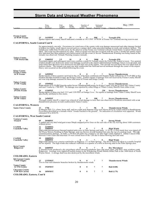
14 WSW Fresno 13 1415PDT 1.0 35 0 0 50K ? Tornado (F0)<br />
Spotter reports <strong>and</strong> county sheriff indicated a tornado at 1415 PDT 14 WSW of Fresno Air Terminal moving west-to-east<br />
CALIFORNIA, South Central Cont'd<br />
for approximately one mile. Occurrence in a rural area of the county with crop damage unassessed <strong>and</strong> other damage limited<br />
to broken tree limbs, small objects moved such as a camper shell, some structural damage to roofs, <strong>and</strong> windows broken. The<br />
tornado was visible from 14 miles away by the observer at the Fresno Air Terminal with an United States Aviation Observation<br />
taken. This event was also captured on video. Dime to nickel-size hail also occurred with the event; a month late spotter report<br />
also indicated that three-quarters inch hail occurred with the event (A Severe Thunderstorm Warning was being issued as the<br />
tornado was observed; Tornado Warning issuance instead).<br />
Tulare County<br />
7 SW Porterville 13 1200PDT 2.5 10 0 0 200K 0 Tornado (F0)<br />
Eyewitness reports <strong>and</strong> subsequent interviews confirm a small F0 Tornado struck the Porterville Airport at noon. Two general<br />
aviation aircraft were destroyed, minor roof damage occurred to the airport administration buildings, fences were downed, <strong>and</strong><br />
some minor farm structures were destroyed one-half mile east of the airport. One aircraft was tied down but was lifted from its<br />
tiedown chains. The tornado was seen one mile southwest of the field <strong>and</strong> moved northeast through the center of the airport.<br />
Heavy rain occurred on the airfield following the event.<br />
Kings County<br />
Fresno County<br />
16 W Fresno 13 1459PDT 0 0 ? ? Severe Thunderstorm<br />
Spotter reports of three-quarters inch hail in the city of Kerman combined with Doppler Radar reflectivity of 55-59 dBZ at this<br />
location <strong>and</strong> other locations in rural, west Kings County. Further reports of damage were not received by Fresno County Sheriff<br />
nor was crop damage assessed for these rural areas of Fresno <strong>and</strong> Kings County.<br />
Tulare County<br />
17 SW Visalia 13 1559PDT 0 0 ? ? Severe Thunderstorm<br />
Radar reports of 55-59 dBZ from the earlier Severe ThunderstormWarning for Kings County was due to track into Tulare County<br />
<strong>and</strong> near Visalia by 1700 PDT. No damage was reported by either Kings or Tulare County Sheriffs from either event.<br />
Tulare County<br />
29 ESE Fresno 24 1320PDT 0 0 ? .2M Severe Thunderstorm<br />
Spotter reports of dime-size hail 1315 <strong>and</strong> 1320 PDT at Orange Cove. No reports of damage from Tulare County Sheriff were<br />
specifically attributed to this storm.<br />
Tulare County<br />
10 SW Tulare 24 1450PDT 0 0 10K ? Severe Thunderstorm<br />
Through county sheriff, a report was relayed of wind damage to trees that was observed in Waukena associated with severe<br />
thunderstorm presence in rural southwestern Tulare County.<br />
CALIFORNIA, Western<br />
Santa Clara County 13 1750 ? ? 5K 0 Thunderstorm Winds<br />
In Morgan Hill, CA, a barn, horse stall, <strong>and</strong> two eight inch diameter trees were blown down by winds related to thunderstorm.<br />
Eyewitness described as a tornado where "clouds reached to the ground". No indication of circulation were apparent. Winds<br />
estimated 50 to 60 KTS.<br />
CALIFORNIA, West South Central<br />
Ventura County<br />
Oxnard 05 2030PDT 0 0 0 Strong Winds<br />
A sudden <strong>and</strong> very brief wind gust to near 50mph snapped power lines on the east side of the city leaving about 1600 customers<br />
without power.<br />
CAZ018 11 2230PDT-<br />
Coachella Valley 12 1500PDT 0 0 ? 0 High Winds<br />
High winds downed power lines <strong>and</strong> toppled palm trees in Palm Springs <strong>and</strong> Indio. A 10- by 15-foot metal door was ripped off<br />
the Plaza Motors building in Palm Springs, <strong>and</strong> was thrown several hundred feet onto the top of a pickup truck. The truck<br />
sustained minor damage. In Indio, a 50-foot tall palm tree crushed a car after high winds toppled it. Indian Canyon Drive<br />
between Vista Chino <strong>and</strong> Interstate 10 were closed most of the 12th due to dense blowing dust <strong>and</strong> s<strong>and</strong>.<br />
CAZ018 19 1000PDT-<br />
Coachella Valley 2000PDT 0 1 ? 0 High Winds<br />
High winds tipped over a tractor-semitrailer on Highway 111 in Palm Springs. The driver had to be taken to a nearby hospital<br />
for his injuries. The high winds also reduced visibilities to a quarter of a mile in blowing s<strong>and</strong> in the Palm Springs area.<br />
Kern County<br />
a dry microburst lines store windows out ni<br />
Ridgecrest. Awnings were ripped off mobile homes in the Whispering Winds Mobile Home Park in the 1400 block of North<br />
Wayne Street. A storage shed was also destroyed by the microburst winds.<br />
Ridgecrest 24<br />
A<br />
1600PDT<br />
thunderstorm produced<br />
0<br />
which<br />
0<br />
downed<br />
?<br />
telephone<br />
0<br />
<strong>and</strong><br />
Dry Microburst<br />
street signs, <strong>and</strong> blew<br />
COLORADO, Eastern<br />
Kit Carson County<br />
7 SSW Flagler<br />
to branches broken by<br />
12<br />
Two<br />
1335MST<br />
four inch diameter<br />
0<br />
thunderstorm<br />
0 ?<br />
winds.<br />
? Thunderstorm Winds<br />
Yuma County<br />
16 NNE Eckley 12 1920MST 0 0 ? ? Hail (0.88)<br />
Cheyenne County<br />
5 SW Kit Carson 16 1850MST 0 0 ? ? Hail (1.75)<br />
COLORADO, Eastern, Cont'd<br />
20


