

Storm Data and Unusual Weather Phenomena - CIG
Storm Data and Unusual Weather Phenomena - CIG
Storm Data and Unusual Weather Phenomena - CIG

Create successful ePaper yourself
Turn your PDF publications into a flip-book with our unique Google optimized e-Paper software.
<strong>Storm</strong> <strong>Data</strong> <strong>and</strong> <strong>Unusual</strong> <strong>Weather</strong> <strong>Phenomena</strong><br />
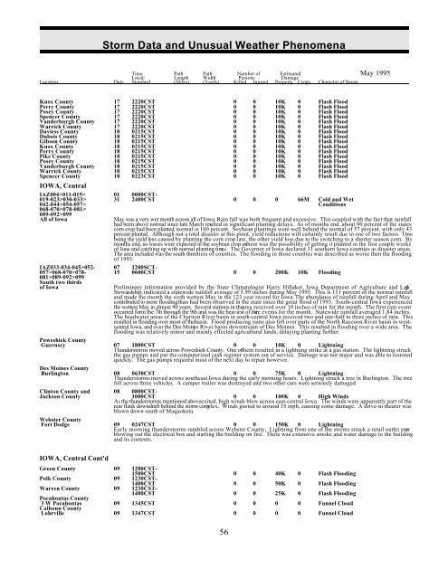
Time Path Path Number of Estimated May 1995<br />
Local/ Length Width Persons Damage<br />
Location Date St<strong>and</strong>ard (Miles) (Yards) Killed Injured Property Crops Character of <strong>Storm</strong><br />
Knox County 17 2220CST 0 0 10K 0 Flash Flood<br />
Perry County 17 2220CST 0 0 10K 0 Flash Flood<br />
Posey County 17 2220CST 0 0 10K 0 Flash Flood<br />
Spencer County 17 2220CST 0 0 10K 0 Flash Flood<br />
V<strong>and</strong>erburgh County 17 2220CST 0 0 10K 0 Flash Flood<br />
Warrick County 17 2220CST 0 0 10K 0 Flash Flood<br />
Daviess County 18 0215CST 0 0 10K 0 Flash Flood<br />
Dubois County 18 0215CST 0 0 10K 0 Flash Flood<br />
Gibson County 18 0215CST 0 0 10K 0 Flash Flood<br />
Knox County 18 0215CST 0 0 10K 0 Flash Flood<br />
Perry County 18 0215CST 0 0 10K 0 Flash Flood<br />
Pike County 18 0215CST 0 0 10K 0 Flash Flood<br />
Posey County 18 0215CST 0 0 10K 0 Flash Flood<br />
V<strong>and</strong>erburgh County 18 0215CST 0 0 10K 0 Flash Flood<br />
Warrick County 18 0215CST 0 0 10K 0 Flash Flood<br />
Spencer County 18 0223CST 0 0 10K 0 Flash Flood<br />
IOWA, Central<br />
IAZ004>011-015> 01 0000CST-<br />
019-023>030-033> 31 2400CST<br />
042-044>054-057><br />
068-070>078-081><br />
0 0 0 66M Cold <strong>and</strong> Wet<br />
Conditions<br />
089-092>099<br />
All of Iowa<br />
May was a very wet month across all of Iowa. Rain fall was both frequent <strong>and</strong> excessive. This coupled with the fact that rainfall<br />
had been above normal since late March resulted in significant planting delays. As of months end, about 80 percent of the states<br />
corn crop had been planted, normal is 100 percent. Soybean plantings were well behind the normal of 57 percent, with only 43<br />
percent planted. Although not a total disaster at this point, yield reductions will certainly result due to one of two factors. One<br />
being the yield loss caused by planting the corn crop late, the other yield loss due to the switching to a shorter season corn. By<br />
months end, no losses were expected in the soybean crop as there was the possibility of getting it planted in the first couple weeks<br />
of June <strong>and</strong> catching up with normal planting times. The Governor of Iowa declared 31 southern Iowa counties as disaster areas.<br />
The area included was the south three tiers of counties. The flooding in those counties was described as worse then the flooding<br />
of 1993.<br />
IAZ033-034-045>052- 07 1200SCT-<br />
057>068-070>078- 15 0600CST 0 0 200K 10K Flooding<br />
081>089-092>099<br />
South two thirds<br />
of Iowa<br />
Preliminary information provided by the State Climatologist Harry Hillaker, Iowa Department of Agriculture <strong>and</strong> L<strong>and</strong><br />
Stewardship, indicated a statewide rainfall average of 5.99 inches during May 1995. This is 151 percent of the normal rainfall<br />
<strong>and</strong> made the month the sixth wettest May in the 123 year record for Iowa. The abundance of rainfall during April <strong>and</strong> May<br />
contributed to more flooding than had been observed in the state since the great flood of 1993. South-central Iowa experienced<br />
the wettest May in almost 90 years. Several stations in thearea received over 10 inches of rain for the month. The first rain event<br />
occurred form the 7th through the 9th <strong>and</strong> was the heaviest of three events for the month. Statewide rainfall averaged 1.84 inches.<br />
The headwater areas of the Chariton River basin in south-central Iowa received two <strong>and</strong> one-half to three inches of rain. This<br />
resulted in flooding over most of the basin. Flood producing rains also fell over parts of the North Raccoon River basin in westcentral<br />
Iowa, <strong>and</strong> over the Des Moines River basin downstream of Des Moines. This resulted in flooding over a wide area. The<br />
flooding was relatively minor <strong>and</strong> mainly effected agricultural l<strong>and</strong>s, delaying planting further.<br />
Poweshiek County<br />
Guernsey 07 1800CST 0 0 10K 0 Lightning<br />
Thunderstorms moved across Poweshiek County. One ofthem resulted in a lightning strike at a gas station. The lightning struck<br />
the gas pumps <strong>and</strong> put the computerized cash register system out of service. Damage was not major <strong>and</strong> was able to restored<br />
quickly. The gas pumps required most of the next day to repair however.<br />
Des Moines County<br />
Burlington 08 0630CST 0 0 75K 0 Lightning<br />
Thunderstorms moved across southeast Iowa during the early morning hours. Lightning struck a tree in Burlington. The tree<br />
fell across three vehicles. A camper trailer was destroyed <strong>and</strong> two other cars were seriously damaged.<br />
Clinton County <strong>and</strong> 08 0800CST-<br />
Jackson County 1000CST 0 0 100K 0 High Winds<br />
As the thunderstorms mentioned aboveexited, high winds blew across east-central Iowa. The winds were apparently part of the<br />
rear flank downdraft behind the storm complex. Winds gusted to around 55 mph, causing some damage. A drive-in theater was<br />
blown down south of Maquoketa.<br />
Webster County<br />
Fort Dodge 09 0247CST 0 0 150K 0 Lightning<br />
Early morning thunderstorms rumbled across Webster County. Lightning from one of the storms struck a retail outlet stor e<br />
blowing out the electrical box <strong>and</strong> starting the building on fire. There was extensive smoke <strong>and</strong> water damage to the building<br />
<strong>and</strong> its contents.<br />
IOWA, Central Cont'd<br />
Green County 09 1200CST-<br />
1500CST 0 0 40K 0 Flash Flooding<br />
Polk County 09 1230CST-<br />
1400CST 0 0 50K 0 Flash Flooding<br />
Warren County 09 1230CST-<br />
1400CST 0 0 25K 0 Flash Flooding<br />
Pocahontas County<br />
3 W Pocahontas 09 1345CST 0 0 0 0 Funnel Cloud<br />
Calhoun County<br />
Lohrville 09 1347CST 0 0 0 0 Funnel Cloud<br />
56


