

Storm Data and Unusual Weather Phenomena - CIG
Storm Data and Unusual Weather Phenomena - CIG
Storm Data and Unusual Weather Phenomena - CIG

Create successful ePaper yourself
Turn your PDF publications into a flip-book with our unique Google optimized e-Paper software.
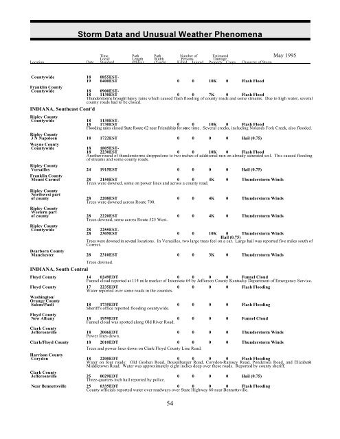
<strong>Storm</strong> <strong>Data</strong> <strong>and</strong> <strong>Unusual</strong> <strong>Weather</strong> <strong>Phenomena</strong><br />
Time Path Path Number of Estimated May 1995<br />
Local/ Length Width Persons Damage<br />
Location Date St<strong>and</strong>ard (Miles) (Yards) Killed Injured Property Crops Character of <strong>Storm</strong><br />
Countywide 18<br />
19<br />
0855EST-<br />
0400EST 0 0 10K 0 Flash Flood<br />
Franklin County<br />
Countywide 18 0900EST-<br />
18 1130EST 0 0 7K 0 Flash Flood<br />
Thunderstorms brought heavy rains which caused flash flooding of county roads <strong>and</strong> some streams. Due to high water, several<br />
county roads had to be closed.<br />
INDIANA, Southeast Cont'd<br />
Ripley County<br />
Countywide 18 1130EST-<br />
18 1730EST 0 0 10K 0 Flash Flood<br />
Flooding rains closed State Route 62 near Friendship for some time. Several creeks, including Nol<strong>and</strong>s Fork Creek, also flooded.<br />
Ripley County<br />
3 N Napoleon 18 1722EST 0 0 0 0 Hail (0.75)<br />
Wayne County<br />
Countywide 18 1805EST-<br />
18 2230EST 0 0 10K 0 Flash Flood<br />
Another round of thunderstorms dropped one to two inches of additional rain on already saturated soil. This caused flooding<br />
of streams <strong>and</strong> some county roads.<br />
Ripley County<br />
Versailles 24 1915EST 0 0 0 0 Hail (0.75)<br />
Franklin County<br />
Mount Carmel 28 2150EST 0 0 4K<br />
Trees were downed, some on power lines <strong>and</strong> across a county road.<br />
0 Thunderstorm Winds<br />
Ripley County<br />
Northwest part<br />
of county 28 2208EST<br />
Trees were downed across Route 700.<br />
0 0 4K 0 Thunderstorm Winds<br />
Ripley County<br />
Western part<br />
of county 28 2220EST<br />
Trees downed, some across Route 525 West.<br />
0 0 4K 0 Thunderstorm Winds<br />
Ripley County<br />
Countywide 28 2255EST-<br />
28 2305EST 0 0 10K 0 Thunderstorm Winds<br />
Hail (0.75)<br />
Trees were downed in several locations. In Versailles, two large trees feel on a car. Large hail was reported five miles south of<br />
Correct.<br />
Dearborn County<br />
Manchester 28 2310EST 0 0 3K 0 Thunderstorm Winds<br />
Trees downed.<br />
INDIANA, South Central<br />
Floyd County 14 0249EDT 0 0 0 0 Funnel Cloud<br />
Funnel cloud reported at 114 mile marker of Interstate 64 by Jefferson County Kentucky Department of Emergency Service.<br />
Floyd County 17 2235EDT 0 0 0 0 Flash Flooding<br />
Water reported over some roads in the counties.<br />
Washington/<br />
Orange County<br />
Salem/Paoli 18 1735EDT<br />
Sheriff's office reported flooding countywide.<br />
0 0 0 0 Flash Flooding<br />
Floyd County<br />
New Albany 18 1959EDT<br />
Funnel cloud was spotted along Old River Road.<br />
0 0 0 0 Funnel Cloud<br />
Clark County<br />
Jeffersonville 18 2006EDT<br />
Power lines down.<br />
0 0 0 0 Thunderstorm Winds<br />
Clark/Floyd County 18 2010EDT 0 0 0 0 Thunderstorm Winds<br />
Trees <strong>and</strong> power lines down on Clark/Floyd County Line Road.<br />
Harrison County<br />
Corydon 18 2200EDT 0 0 0 0 Flash Flooding<br />
Water on four roads: Old Goshen Road, Bousalbarger Road, Corydon-Ramsey Road, Pondersoa Road, <strong>and</strong> Elizabeth-<br />
Middletown Road. Water was approximately eight inches deep over these roads. Reported by county sheriff.<br />
Clark County<br />
Jeffersonville 25 0029EDT<br />
Three-quarters inch hail reported by police.<br />
0 0 0 0 Hail (0.75)<br />
Near Bennettsville 25 0335EDT 0 0 0 0 Flash Flooding<br />
County officials reported water over roadways over State Highway 60 near Bennettsville.<br />
54


