Storm Data and Unusual Weather Phenomena - CIG
Storm Data and Unusual Weather Phenomena - CIG
Storm Data and Unusual Weather Phenomena - CIG
- No tags were found...
You also want an ePaper? Increase the reach of your titles
YUMPU automatically turns print PDFs into web optimized ePapers that Google loves.
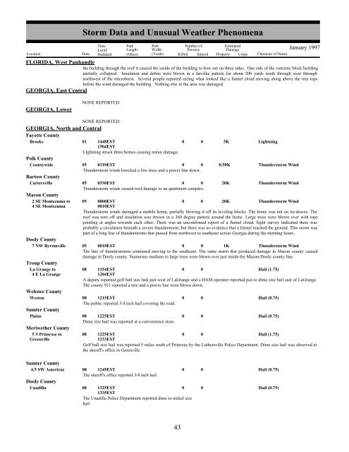
<strong>Storm</strong> <strong>Data</strong> <strong>and</strong> <strong>Unusual</strong> <strong>Weather</strong> <strong>Phenomena</strong>TimeLocal/PathLengthPathWidthNumber ofPersonsEstimatedDamageLocation Date St<strong>and</strong>ard (Miles) (Yards) Killed Injured Property Crops Character of <strong>Storm</strong>January 1997FLORIDA, West Panh<strong>and</strong>lethe building through the roof it caused the inside of the building to bow out on three sides. One side of the concrete block buildingpartially collapsed. Insulation <strong>and</strong> debris were blown in a fan-like pattern for about 200 yards south through west throughnorthwest of the microburst. Several people reported seeing what looked like a funnel cloud moving along above the tree topsbefore the wind damaged the building. Nothing else in the area was damaged.GEORGIA, East CentralGEORGIA, LowerNONE REPORTED.NONE REPORTED.GEORGIA, North <strong>and</strong> CentralFayette CountyBrooks01 1448EST1504EST0 0 5KLightningLIghtning struck three homes causing minor damage.Polk CountyCountywide05 0310EST0 0 0.50KThunderstorm WindThunderstorm winds knocked a few trees <strong>and</strong> a power line down.Bartow CountyCartersville05 0330EST0 0 20KThunderstorm WindThunderstorm winds caused roof damage to an apartment complex.Macon County2 SE Montezuma to 05 0800EST0 0 20KThunderstorm Wind4 SE Montezuma0810ESTThunderstorm winds damaged a mobile home, partially blowing it off its leveling blocks. The home was not on tie-downs. Theroof was torn off <strong>and</strong> insulation was strewn in a 360 degree pattern around the home. Large trees were blown over with topspointing at angles towards each other. There was an unconfirmed report of a funnel cloud. Sight survey indicated there wasprobably a circulation beneath a severe thunderstorm, but there was no evidence that a funnel reached the ground. This storm waspart of a long line of thunderstorms that passed from northwest to southeast across Georgia during the morning hours.Dooly County7 NW Byromville 05 0810EST0 0 1KThunderstorm WindThe line of thunderstorms continued moving to the southeast. The same storm that produced damage in Macon county causeddamage in Dooly county. Numerous medium to large trees were blown over just inside the Macon-Dooly county line.Troup CountyLa Grange to08 1154EST0 0Hail (1.75)4 E La Grange1204ESTA deputy reported golf ball size hail just west of LaGrange <strong>and</strong> a HAM operator reported pea to dime size hail east of LaGrange.The county 911 reported a tree <strong>and</strong> a power line were blown down.Webster CountyWeston08 1215EST0 0Hail (0.75)The public reported 3/4 inch hail covering the road.Sumter CountyPlains08 1225EST0 0Hail (0.75)Dime size hail was reported at a convenience store.Meriwether County5 S Primrose to 08 1225EST0 0Hail (1.75)Greenville1233ESTGolf ball size hail was reported 5 miles south of Primrose by the Luthersville Police Department. Dime size hail was observed atthe sheriff's office in Greenville.Sumter County4.5 SW Americus 08 1245EST0The sheriff's office reported 3/4 inch hail.Dooly CountyUnadilla08 1325EST01335ESTThe Unadilla Police Department reported dime to nickel sizehail.00Hail (0.75)Hail (0.75)36 43


