Storm Data and Unusual Weather Phenomena - CIG
Storm Data and Unusual Weather Phenomena - CIG
Storm Data and Unusual Weather Phenomena - CIG
- No tags were found...
You also want an ePaper? Increase the reach of your titles
YUMPU automatically turns print PDFs into web optimized ePapers that Google loves.
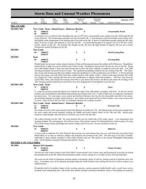
DELAWAREDEZ001>004DEZ001DEZ002DEZ001>002DEZ001>004DEZ001DISTRICT OF COLUMBIADCZ001<strong>Storm</strong> <strong>Data</strong> <strong>and</strong> <strong>Unusual</strong> <strong>Weather</strong> <strong>Phenomena</strong>TimeLocal/PathLengthPathWidthNumber ofPersonsEstimatedDamageLocation Date St<strong>and</strong>ard (Miles) (Yards) Killed Injured Property Crops Character of <strong>Storm</strong>January 1997New Castle - Kent - Inl<strong>and</strong> Sussex - Delaware Beaches03061000EST2300EST0 0Unseasonably WarmA persistent west to southwest flow throughout the start of 1997 led to unseasonably warm weather from the 3rd through the 6thacross Delaware. The warmest days statewide were the 3rd <strong>and</strong> the 5th. A weak backdoor cold front brought mostly cloudy skies<strong>and</strong> slightly cooler temperatures to the northern part of the state on the 4th. In spite of a cold frontal passage, during the 6th, someplaces in Sussex County still managed to reach into the 60s. A record breaking high of 62 degrees was set at the New CastleCounty Airport on the 3rd. The warmest day though was the 5th when the high reached 65 degrees, but was not a record.Georgetown reached 69 degrees on the 4th.New Castle09 1000EST2200EST0 0Sleet/Freezing RainKent09 1000EST0 0Freezing Rain1700ESTDouble barrel low pressure systems spread a mixture of sleet <strong>and</strong> freezing rain across the northern half of Delaware. Precipitationstarted briefly as light snow across northern New Castle County. Precipitation spread across the area by noon on the 9th. Strongeast winds helped change it from sleet <strong>and</strong> freezing rain to plain rain from southeast to northwest across the state. Very littlefreezing precipitation occurred in Sussex County. The significant precipitation ended by the late evening of the 9th. The wintrymix of sleet <strong>and</strong> freezing rain did cause slippery roads <strong>and</strong> contributed to a fatal accident just west of Dover. A 49-year-old <strong>and</strong>66-year-old woman were both killed when they collided head-on with another vehicle. Farther north along Interstate 495 trafficwas stopped for "miles" during rush hour due to the combination of slippery roads <strong>and</strong> accidents., The lows went from thecentral Ohio Valley <strong>and</strong> Georgia the morning of the 9th to Lake Huron (the former) <strong>and</strong> Boston (the latter) the morning of the10th. Keeping separate identities prevented these lows from dropping heavier precipitation across the area.New Castle - Kent11 0100EST0 0Snow0800ESTA weak low pressure system developed over Virginia the night of the 10th along a secondary cold front. As the low movednortheast <strong>and</strong> reached Block Isl<strong>and</strong> Rhode Isl<strong>and</strong> during the morning of the 11th, a swath of light snow accompanied it during thepre-dawn hours. For most places across central <strong>and</strong> northern Delaware, this was the first measurable snowfall of the season.Accumulations though were light, mainly between 1 <strong>and</strong> 2 inches across Kent <strong>and</strong> New Castle Counties. Just a trace of snow fellat Lewes. Since the snow fell very early on a Saturday morning, few accidents occurred.New Castle - Kent - Inl<strong>and</strong> Sussex - Delaware Beaches17 0100EST0 0Extreme Cold20 0900ESTThe coldest air mass of the winter season moved into Delaware on Friday the 17th. The high pressure system came straight fromthe arctic tundra <strong>and</strong> moved southeast reaching the Middle <strong>and</strong> South Atlantic States on the 19th <strong>and</strong> 20th. Strong gustynorthwest winds brought wind chill factors well below zero on the 17th <strong>and</strong> 18th.The coldest morning was the 19th. For most locations this was the coldest day of the winter season. Low temperatures thatmorning included 2F in Georgetown, 4F in Prices Corner (New Castle County), 5F in Pennyhill (New Castle County), 6F at theNew Castle County Airport <strong>and</strong> Bridgeville (Sussex County) <strong>and</strong> 7F in Lewes. No new record lows were set.New Castle22 0500EST0 0Black Ice0800ESTA moist south to southeast flow from Delaware Bay passing over road surfaces that were very cold from the recent deep freezehelped black ice to form on roadways, bridges <strong>and</strong> overpasses the morning of the 22nd. This thin layer of ice that is virtuallyimpossible to detect helped contribute to three traffic fatalities <strong>and</strong> over 100 injuries in the Greater Philadelphia MetropolitanArea. All the fatalities occurred in Pennsylvania <strong>and</strong> New Jersey.District Of Columbia09 0700EST1600EST0 0Winter <strong>Weather</strong>The first city-wide winter weather event of the 1996/97 season spread a mix of snow, sleet, <strong>and</strong> freezing rain across the city duringthe daylight hours of the 9th. Before the precipitation ended, a crusty coating of 2 or 3 inches of snow <strong>and</strong> sleet had fallen.The event was the result of subtropical moisture rapidly overrunning a dome of cold air, causing a period of moderate snow <strong>and</strong>sleet. A secondary wave of low pressure developed along the North Carolina coast, locking the low-level cold air in place overinl<strong>and</strong> locations.Precipitation had an immediate impact on the morning commute, causing numerous fender-benders <strong>and</strong> a several more seriousaccidents in the metropolitan area. One of the more notable accidents occurred in Southeast, where a 10-car pileup was noted on30 37


