

Mooring Ground Information Werribee River - Parks Victoria
Mooring Ground Information Werribee River - Parks Victoria
Mooring Ground Information Werribee River - Parks Victoria

You also want an ePaper? Increase the reach of your titles
YUMPU automatically turns print PDFs into web optimized ePapers that Google loves.
<strong>Mooring</strong> <strong>Ground</strong> <strong>Information</strong><br />
<strong>Werribee</strong> <strong>River</strong><br />
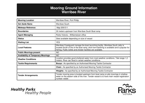
<strong>Mooring</strong> Location<br />
Set Aside Name<br />
<strong>Werribee</strong> <strong>River</strong>, Port Phillip<br />
<strong>Werribee</strong> South<br />
Melways Reference Map 209 E11<br />
Boundaries<br />
Agent Managing<br />
Status<br />
Waiting List<br />
Local Features<br />
Public <strong>Mooring</strong>s present<br />
Availability of Temporary <strong>Mooring</strong>s<br />
Weather Conditions<br />
Tackle Requirements<br />
30 meters upstream from <strong>Werribee</strong> South Boat ramp<br />
<strong>Parks</strong> <strong>Victoria</strong> – Williamstown office<br />
Sites available depending on size of vessel<br />
YES<br />
<strong>Werribee</strong> Coastguard manage the boat launching facility. <strong>Werribee</strong> South Jetty is<br />
located South of the of the boat ramp, short term berthing is available and is popular for<br />
fishing. Public toilets and shower facilities are available.<br />
NO<br />
NO<br />
Location provides good sheltered water from most weather conditions. Tide range 1.2<br />
meters. <strong>River</strong> can flood in certain weather conditions.<br />
Buoys : As specified by an Authorised <strong>Mooring</strong> Tackle Contractor<br />
Chain : As specified by an Authorised <strong>Mooring</strong> Tackle Contractor<br />
Weights : As specified by an Authorised <strong>Mooring</strong> Tackle Contractor<br />
Tender Arrangements<br />
Tender mooring area is located upstream from boat ramp on pile moorings in shallow<br />
water on the eastern side of the river. Tender vessel is to have main vessel registration<br />
number visible
Access<br />
Car / trailer parking is provided at boat launching facility.<br />
Contact <strong>Parks</strong> <strong>Victoria</strong> 13 19 63
BEACH ROAD<br />
0 0.10 0.20<br />
Map Produced using <strong>Parks</strong> <strong>Victoria</strong>’s ParkView Mapping<br />
System<br />
Date Produced: 11 August 2010<br />
GEOCENTRIC DATUM OF AUSTRALIA – (GDA94)<br />
STATE DIGITAL MAPBASE USED WITH PERMISSION<br />
OF LAND VICTORIA,<br />
DEPARTMENT OF SUSTAINABILITY AND<br />
ENVIRONMENT.<br />
This map supercedes all previous editions.<br />
)<br />
<strong>Mooring</strong> <strong>Ground</strong> <strong>Information</strong><br />
<strong>Werribee</strong> <strong>River</strong>, Port Phillip<br />
kilometers


