Site 115 Land at 126-130 Lower Road, Lower Bemerton.pdf 258kb
Site 115 Land at 126-130 Lower Road, Lower Bemerton.pdf 258kb
Site 115 Land at 126-130 Lower Road, Lower Bemerton.pdf 258kb

You also want an ePaper? Increase the reach of your titles
YUMPU automatically turns print PDFs into web optimized ePapers that Google loves.
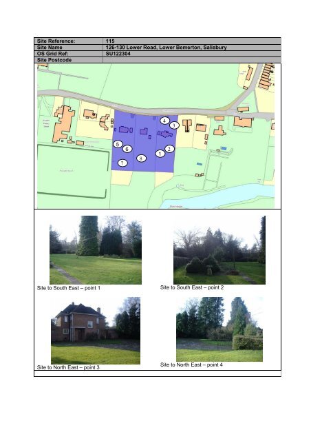
<strong>Site</strong> Reference: <strong>115</strong><br />
<strong>Site</strong> Name<br />
<strong>126</strong>-<strong>130</strong> <strong>Lower</strong> <strong>Road</strong>, <strong>Lower</strong> <strong>Bemerton</strong>, Salisbury<br />
OS Grid Ref:<br />
SU122304<br />
<strong>Site</strong> Postcode<br />
4<br />
3<br />
5<br />
7<br />
6<br />
8<br />
1<br />
2<br />
<strong>Site</strong> to South East – point 1 <strong>Site</strong> to South East – point 2<br />
<strong>Site</strong> to North East – point 3<br />
<strong>Site</strong> to North East – point 4
<strong>Site</strong> to West – point 5 <strong>Site</strong> to West – point 6<br />
<strong>Site</strong> to South West – point 7 <strong>Site</strong> to South of site – point 8<br />
<strong>Site</strong> Use<br />
<strong>Site</strong> Area<br />
0.59 hectares<br />
Local Plan Reference (if Inset map Salisbury West<br />
applicable)<br />
Current site use: • The site currently consists 3 detached dwellings with associ<strong>at</strong>ed<br />
gardens<br />
Previous use: • N/A<br />
Capacity C<strong>at</strong>egory • Brownfield<br />
<strong>Site</strong> Characteristics<br />
Topography • Predomin<strong>at</strong>ely fl<strong>at</strong> land although slightly sloping to the South of the site<br />
Access: • The site can be accessed off <strong>Lower</strong> <strong>Road</strong>.<br />
Flood Risk • The site adjoins flood zone 3 according to the Environment Agency<br />
Public Transport<br />
Provision<br />
• A number of bus services can be caught from the area, which serves<br />
all parts of the district. The site is also loc<strong>at</strong>ed in close proximity of the<br />
Loc<strong>at</strong>ion of nearest<br />
services<br />
city centre of Salisbury, being approxim<strong>at</strong>ely 2.5km away.<br />
• The site is loc<strong>at</strong>ed in the Ward of <strong>Bemerton</strong> and has easy access to a<br />
range of local facilities including both primary and secondary schools,<br />
post office, shop, public houses, doctors and dentist. More facilities are<br />
available in the city centre.<br />
Physical Constraints • River to the South of the site<br />
• <strong>Land</strong>scape<br />
Adjacent land uses • To the West of the site is recre<strong>at</strong>ion open space and to the East are<br />
existing dwellings and to the south is the Harnham W<strong>at</strong>er Meadows.<br />
Surrounding Storey<br />
Height<br />
Local Plan Policy<br />
constraints<br />
Timeframe for<br />
development<br />
Current Planning<br />
permission<br />
Relevant Planning<br />
History<br />
• Two storey dwellings<br />
• H16 – The site is loc<strong>at</strong>ed within the Housing Policy Boundary<br />
• C11 – The site is loc<strong>at</strong>ed next to an Area of High Ecological Value<br />
• CN21 – Area of Special Archaeological Significance<br />
• Before 2011<br />
• None<br />
• None
Estim<strong>at</strong>ed dwelling<br />
capacity on site<br />
• C.17 <strong>at</strong> 30 dph (area is predomin<strong>at</strong>ely characterised by large plot sizes<br />
so actual number allowed would have to reflect this).<br />
Known Developer<br />
• None beyond agent and landowner<br />
Interest<br />
Suitability for nonhousing<br />
development<br />
• The site is small in size and is within an existing residential area, and<br />
would therefore not be suitable for non-housing development.<br />
Deliverability • Deliverable although there are issues over landscape<br />
Developability • The site is rel<strong>at</strong>ively large in size and in principle is suitable for<br />
redevelopment.<br />
• The river to the south and the impact any development will have on the<br />
area of high ecological value are consider<strong>at</strong>ions in any future<br />
development.<br />
• Plot sizes in this area are traditionally large in size and therefore future<br />
development would need to respect this.<br />
• The site is loc<strong>at</strong>ed within close proximity to an area of high ecological<br />
value. The Harnham W<strong>at</strong>er Meadows are afforded a certain amount of<br />
protection and this along with the need to ensure the existing character<br />
of the area is protected could make the site un-developable.<br />
• Furthermore there are traffic implic<strong>at</strong>ions with the road th<strong>at</strong> runs<br />
alongside the site, which would need to be addressed.<br />
Comments:<br />
Part of the site could come forward for development immedi<strong>at</strong>ely subject to assessment <strong>at</strong> the planning<br />
applic<strong>at</strong>ion stage, as it is loc<strong>at</strong>ed within the Housing Policy Boundary as defined by the current Salisbury<br />
District Local Plan.<br />
In terms of inclusion in the SHLAA it is considered th<strong>at</strong> due to the site being Brownfield, in principle it is<br />
suitable for redevelopment. The site would only be suitable for low density housing development<br />
although issues of access and landscape/sensitivity would have to be addressed.