RiverBend Master Plan - ECIDA
RiverBend Master Plan - ECIDA
RiverBend Master Plan - ECIDA

Create successful ePaper yourself
Turn your PDF publications into a flip-book with our unique Google optimized e-Paper software.
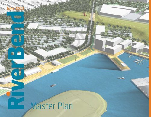
June 2011<br />
<strong>RiverBend</strong><br />
<strong>Master</strong> <strong>Plan</strong>
This report was prepared for the Buffalo Urban<br />
Development Corporation, the City of Buffalo, and<br />
the New York State Department of State with state<br />
funds provided through the Brownfield Opportunity<br />
Areas Program and funds provided by National<br />
Grid.<br />
Mayor Byron W. Brown
1<br />
Table of Contents<br />
Introduction 3<br />
Restore, Connect, Transform, Engage 7<br />
Connect 7<br />
Restore 13<br />
Transform 19<br />
Engage 27
2<br />
<strong>RiverBend</strong><br />
The new image of <strong>RiverBend</strong> is of a green, modern,<br />
and vital community. It represents a tremendous<br />
opportunity to reposition the postindustrial land<br />
and South Buffalo in a way that is complementary<br />
and supportive of the future of the downtown and<br />
the greater region.
Introduction<br />
The redevelopment plan for <strong>RiverBend</strong> aims to attract public and private<br />
investment. Over the next several decades, this neglected waterfront site will<br />
transform into a key contributor to the economic health of the City of Buffalo<br />
and region. The new image of Riverbend is of a green, modern, and vital urban<br />
neighborhood. Green is embodied in the ecological transformation of the site,<br />
a strong commitment to alternative energies, and a newly created public open<br />
space system. Modern refers to new contemporary architecture and landscapes<br />
where the functional stormwater management strategies are made a visible,<br />
beautiful part of the aesthetic of the site. And the new community’s role as<br />
a regional destination—for jobs, and as a contemporary expression of the<br />
city’s culture —assure it will be a vital place. As part of the largest Brownfield<br />
Opportunity Area (BOA) funded by the State of New York (New York Department<br />
of State), the <strong>RiverBend</strong> site still bears imprints of the departed steel fields,<br />
with residual infrastructure, disturbed soil, contamination and an active rail line.<br />
<strong>RiverBend</strong> was acquired in 2007 by the Buffalo Urban Development Corporation<br />
with assistance from the City of Buffalo as part of an initiative to continue to<br />
guide redevelopment of the City of Buffalo’s former vacant industrial brownfields<br />
and spur greater private sector investment and job creation in Buffalo. Today<br />
it represents a tremendous opportunity to reposition this post-industrial land<br />
and the South Buffalo region of the city, in a way that is complementary and<br />
supportive of the future of the downtown and the greater region.<br />
<strong>RiverBend</strong>’s vast size, strategic location, and extensive Buffalo River frontage<br />
are assets to build on to create a new type of development that is differentiated<br />
from other industrial, logistics, office, research and development, and mixed-use<br />
projects. <strong>RiverBend</strong> is part of the 1,900 acre South Buffalo BOA that contains<br />
the city’s greatest geographic concentration of land previously home to the city’s<br />
heavy industries. While those jobs and activities have largely left South Buffalo,<br />
relics of the former era remain in the form of industrial structures – historic grain<br />
elevators, bridges, and dramatic structures that mark the skyline and establish a<br />
distinctive visual identity for <strong>RiverBend</strong> unique from downtown and other areas.<br />
These abandoned industrial features have been selectively reinterpreted in<br />
the future vision for <strong>RiverBend</strong>. From a waterfront promenade that traces the<br />
dramatic steel bulkheaded river’s edge to park design or the implementation of<br />
new contemporary wind turbines throughout the site, <strong>RiverBend</strong> makes visible<br />
its industrial legacy while looking toward a new, clean energy future. Legacy<br />
infrastructure from the area’s industrial past—from utilities to extensive shoreline<br />
bulkheads—also represents substantial in-place site investments that can serve<br />
future development.<br />
Existing <strong>RiverBend</strong> Site Facts<br />
• South Buffalo Opportunity Area – 1,900 acres<br />
• <strong>RiverBend</strong> Site – 260 acres<br />
• 2 miles south of Downtown Buffalo<br />
• 1.3 miles of riverfront<br />
• Former Republic Steel site<br />
Future <strong>RiverBend</strong> Site Facts<br />
• 3.3 million gross square feet of development<br />
• 3,550 new on-site jobs created<br />
• 1,200 linear feet new public promenade<br />
• 9 large commercial and 6 mini wind turbines<br />
The site offers views to Downtown Buffalo.<br />
3
4<br />
Future vision for <strong>RiverBend</strong>
5<br />
Dramatic structures along the Buffalo River<br />
<strong>RiverBend</strong> will offer a unique, integrated community with contemporary<br />
architecture, new public parks, an ecologically inspired environment, and<br />
renewable energy unlike others. Leveraging the attractive riverfront location<br />
and a legible “green” identity related to outdoor spaces and energy efficiency,<br />
<strong>RiverBend</strong> will serve to complement, rather than compete with Buffalo’s<br />
downtown.<br />
The market focuses on an employment base with a potential mix of uses<br />
that is distinct from downtown such as light industrial, logistics warehousing,<br />
distribution, incubator or scale-up manufacturing sites, an indoor sports arena,<br />
research & development (emerging and established entities), office, retail, and<br />
residential. <strong>RiverBend</strong> draws upon regional assets, real estate and economic<br />
trends, and site-specific attributes to drive demand. The Buffalo metropolitan<br />
area has a diverse regional employment base and a regionally competitive<br />
industrial market, enhanced by proximity to Buffalo Lakeside Commerce Park.<br />
The City’s growing economic anchors work together to promote the transfer<br />
of research to commercialization. Key partners in Buffalo’s future include<br />
the Buffalo Niagara Medical Center, with a robust contribution to the city’s<br />
biomedical sector at the University of Buffalo campus and plans to invest five<br />
billion dollars in a downtown health professions campus. Other key partners<br />
include downtown incubator companies, the Larkin District and Lakeside<br />
Commerce Park.<br />
Major transportation advantages, including road, freight, and waterway access,<br />
bolster <strong>RiverBend</strong>’s appeal as part of a regionally competitive light industrial and<br />
logistics market. <strong>RiverBend</strong>’s scale also allows for a flexible range of parcels that<br />
Bridge abutments<br />
can be adapted to a variety of development needs and accommodate diverse<br />
users who seek proximity to a dense, urban environment, but are not feasible in<br />
the downtown due to land values, limited site areas, and required building types.<br />
Still, the proximate location and clear views to the downtown skyline reinforce<br />
<strong>RiverBend</strong>’s close relationship to the center city, and distinct advantages over<br />
suburban sites. Bridge abutments (pictured above) support a future pedestrian<br />
bridge linking <strong>RiverBend</strong> to the City’s greenway along the Buffalo Rivery.<br />
Building on the compelling image of a future district with a unique sense of<br />
place in the City of Buffalo, integrating mega-scale relics of the site’s industrial<br />
past as centerpieces of its public realm, and making stronger connections<br />
with the lakefront, greenway network, and the central business district will<br />
position <strong>RiverBend</strong> to flourish over the next thirty years. Investment in <strong>RiverBend</strong><br />
represents a commitment to the future health of post-industrial urban cores, to<br />
South Buffalo, and the region.<br />
Strategically significant to the city and region, <strong>RiverBend</strong>’s redevelopment<br />
will extend substantial benefits beyond its boundaries by generating real<br />
estate value, property tax revenues, and jobs. It is estimated that economic<br />
activity at the Riverbend site will create approximately 3,550 jobs at full buildout,<br />
depending on the mix and density of uses. <strong>RiverBend</strong> is designed to be<br />
developed flexibly over time with key features that differentiate it and make it a<br />
desirable location. This approach represents an appropriate strategy, however at<br />
this writing the state of the national economy, and local challenges of economy<br />
and changing demographics do not support major business growth in the short<br />
term.
6<br />
connect<br />
A new system of roads, pedestrian circulation, and<br />
transit define the framework for the urban grid and<br />
create a flexible layout of open space and parcels<br />
that are adaptable to the market and of a walkable<br />
scale.
Restore, Connect, Transform, Engage<br />
A new road and urban street system will connect <strong>RiverBend</strong> to its surroundings,<br />
to downtown, and make links to the regional economy. A comprehensive green<br />
infrastructure plan will restore damaged ecosystems and allow the riverfront to<br />
be used and appreciated by the local community. Over three million square feet<br />
of new development will transform the vacant site into an active engine of job<br />
creation for the region. Finally, the site will again engage the local community,<br />
working together with the City and other partners to reposition Buffalo for<br />
the future.<br />
7<br />
Connect<br />
The master plan for <strong>RiverBend</strong> envisions a transformation in scale for this former<br />
industrial site, from the massive infrastructure of the industrial era to a more<br />
human-scaled community that connects to early master planning efforts for the<br />
city, to the city’s urban grid, and to the residential neighborhoods to the east.<br />
Memories of those historical, industrial icons remain, but the overall experience<br />
of the site will be a contemporary and sustainable community, unlike anywhere<br />
in or around Buffalo. A new system of roads, pedestrian circulation, and bus<br />
transit define the framework for the urban grid and create a flexible layout<br />
of parcels that are adaptable to meet the market and at a walkable and<br />
human scale.<br />
<strong>RiverBend</strong> Illustrative <strong>Plan</strong>
8<br />
Views enhanced by the urban design link industrial icons with the downtown<br />
Heritage<br />
<strong>RiverBend</strong>’s location affords myriad views that are enhanced by the urban<br />
design of the site, which emphasizes visual connections to downtown, the river,<br />
and industrial icons. Views from the publically accessible riverfront promenade<br />
or from higher scale buildings in the marina development and key areas of<br />
Republic Park offer visual access to both the historic skyscrapers of downtown<br />
and to the interesting industrial structures that remain along the Buffalo River,<br />
including the historically protected grain elevators and magnificently scaled<br />
steel trusses. New buildings and open spaces are carefully oriented to maximize<br />
open views to downtown, as well as filtered views through the new forest of trees<br />
within the site and along the restored naturalized river edges.<br />
While views from the site to downtown are critically important, future <strong>RiverBend</strong><br />
will also include iconic elements that create new landmarks to capture views<br />
toward Riverbend that will be visible from Downtown Buffalo and the surrounding<br />
areas. A linear array of 95 to 165 foot tall wind turbines line the western edge of<br />
the site, including five utility scale turbines along the railroad edge. Views of the<br />
wind turbines express a cleaner energy future, while making reference to the<br />
site’s productive past as a major steel plant. New symbols of wind energy now<br />
have a place alongside the relics of the Republic Steel <strong>Plan</strong>t, with a scale that<br />
is visible from a distance and holds its own among the massive grain elevators<br />
and steel structures.<br />
A twelve foot tall capped containment cell bisects the north and south quadrants<br />
of <strong>RiverBend</strong>, ranging in width from 300 to 575 feet and spanning 1,200 feet in<br />
length. To mediate the potential barrier, a new MeadowWorks Park is designed<br />
The MeadowWorks Park provides views to downtown Buffalo<br />
as a meadow landscape on top of the area that takes advantage of the high<br />
ground. Pedestrian trails lead up to the MeadowWorks from the neighborhoods<br />
east of the site and the marina district. <strong>RiverBend</strong> Drive, the district’s new main<br />
street, connects through the site by extending up and over the containment area<br />
so that all travelers through <strong>RiverBend</strong> gain dramatic views from an elevated<br />
position and experience MeadowWorks Park.<br />
<strong>RiverBend</strong>’s urban design concept connects to ideas embodied in the early<br />
city plans that shaped Buffalo growth. The city’s first formal development was<br />
outlined in Ellicott’s 1804 <strong>Master</strong> <strong>Plan</strong>, which established the core downtown<br />
square and a series of radial boulevards linking to surrounding blocks. Ellicott’s<br />
plan, however, only extended as far south as the Buffalo River, leaving the<br />
<strong>RiverBend</strong> development area separate from downtown. Frederick Law Olmsted<br />
produced an open space plan for the city that created a series of parks within<br />
the downtown, its surroundings, and on the waterfront, with plans that extended<br />
south of <strong>RiverBend</strong>. The parks were linked by a network of green parkways and<br />
planted traffic circles that collectively created the Buffalo Olmsted Park System.<br />
Support for Olmsted’s plan has had a recent renaissance in the city, supported<br />
by increased maintenance and reinvestment from public and private resources,<br />
as well as a 2008 report outlining the plan’s revival, “The Olmsted City: The<br />
Buffalo Olmsted Park System <strong>Plan</strong> for the 21st Century.” No parks or parkways<br />
were planned through <strong>RiverBend</strong> by Ellicott or Olmsted. However future<br />
development of the site provides the opportunity to reconnect the site to the<br />
city grid and to extend Olmsted’s city-wide park network through a connected<br />
system of green infrastructure.
Neighborhood Connections<br />
Five street typologies compose the <strong>RiverBend</strong> street network. A defining feature<br />
of the <strong>RiverBend</strong> district is the integration with the existing city street, South<br />
Park Avenue, in the northern half of the site. With a ninety-foot right of way that<br />
is lined with new mixed use commercial buildings, South Park Avenue connects<br />
<strong>RiverBend</strong> to the First Ward, Larkin district and downtown to the north, as well<br />
as Hickory Woods to the immediate east, and the balance of South Buffalo. The<br />
street width accommodates bike lanes in both directions and space for potential<br />
transit in the future, such as a trolley or streetcar, to be integrated into the street.<br />
Currently, South Park Avenue is the only existing road linking <strong>RiverBend</strong> to its<br />
surroundings. A new north-south connection will be created that extends from<br />
Tifft Street at the southern boundary of <strong>RiverBend</strong> and along the eastern edge of<br />
the site along the existing Rittling right of way, before crossing the site south of<br />
the containment cell. This alignment of <strong>RiverBend</strong> Drive does not travel through<br />
the industrial area of site, below the containment cell, allowing this area to<br />
remain extremely flexible for large parcel development in the future. <strong>RiverBend</strong><br />
Drive is the gateway street within the plan and its course allows drivers through<br />
the site to take in the view of the MeadowWorks Park before arriving at the<br />
dramatic bend in the Buffalo River where the new Waterfront Promenade<br />
and Marina District converge, presenting a strong arrival image for new<br />
development. Riverbend Drive varies from a one-hundred-twenty feet right-ofway<br />
through the southern area of the site down to a eighty five feet right-of-way<br />
as it exits the promenade area and turns into the denser, mixed use northern<br />
district. This narrower width still accommodates a two-lane, two-way street with<br />
parking on both sides and generous pedestrian zones with dedicated sidewalk<br />
and integrated bioswales for stormwater management.<br />
9<br />
Building off of South Park Avenue and <strong>RiverBend</strong> Drive, the two primary streets<br />
in the development, are a series of smaller connective streets that create a<br />
flexible urban grid that organizes future development. The southern zone<br />
remains largely uninterrupted by public roads in order to retain the large, flexible<br />
parcels that are desirable for industrial development. Entrance to these parcels<br />
is provided through a connection to <strong>RiverBend</strong> Drive. Within the northern zone, a<br />
network of smaller east-west and north-south connector streets provide access<br />
to future development and parking while extending the walkable, human-scale<br />
pattern of South Park Avenue and <strong>RiverBend</strong> Drive.<br />
Vehicular and pedestrian circulation<br />
[1] 120 FT primary st row (riverBend Commerce Park)<br />
[2] 90 FT primary strow (south park avenue)<br />
[3] 85 FT primary st row (riverbend drive & connector)<br />
[4] 75 FT row (east/west connectors)<br />
[5] 70 FT row (riverbend drive)<br />
Trails<br />
Parking lots
10<br />
Regional Connections<br />
A new arterial road, Riverbend Drive, aligns along the eastern edge of the<br />
<strong>RiverBend</strong> site before turning west into the heart of the development zone<br />
and connecting to South Park. (Currently, the southern portion of the future<br />
<strong>RiverBend</strong> Drive already exists as the Tifft Street arterial.) Where <strong>RiverBend</strong><br />
Drive turns west to enter the site, another connection is possible that would be<br />
constructed to connect the site and Tifft Street north to I-190 at an improved<br />
interchange in the Seneca / Elk / Bailey area. This alignment allows seamless<br />
integration with a future Southtowns Connector. The proposed road consists of a<br />
new four-lane (or two-lane expandable to four-lane) arterial road with signalized<br />
intersections at Seneca Street, Elk Street, and South Park Avenue. New on/off<br />
ramps will be constructed at the existing Seneca Street interchange on I-190<br />
with the alignment following a former railroad right-of-way to a new fixed bridge<br />
over the Buffalo River, beyond the river’s navigable portion for commercial<br />
vessels, where it aligns with Riverbend Drive eventually to the intersection with<br />
Tifft Street.<br />
The master plan remains flexible to support future decisions related to the<br />
Southtowns Connector / Buffalo Outer Harbor Project. In the future, the<br />
Southtowns Connector can link directly to the <strong>RiverBend</strong> Drive alignment at the<br />
southern end of the site.The Southtowns Connector project includes a proposed<br />
series of transportation improvements that collectively will improve road access<br />
to key development sites including <strong>RiverBend</strong> and Lakeside Commerce Park. It<br />
will also provide adequate commuter and commercial traffic service between the<br />
Southtowns and Downtown, improve access to existing and developing public<br />
recreational areas; and enhance waterfront access for alternative modes of<br />
transportation (transit, bicycles and pedestrians).<br />
Transit accessibility is one of the most powerful tools for transformation of<br />
an urban site. A future transit line is accommodated in the master plan for<br />
<strong>RiverBend</strong>, to be located in the center of South Park Avenue, linking <strong>RiverBend</strong><br />
to the central business district and moving employees between the major<br />
employment centers of downtown, the Buffalo Niagara Medical Campus, Larkin<br />
District, and <strong>RiverBend</strong>. In the near term, increased bus service will move<br />
greater numbers of people, while in the future a possible light rail connection will<br />
improve the level of service provided. This selected route for future transit builds<br />
on existing proposals for a new line from Downtown to the airport, and provides<br />
a new link between downtown and existing residential neighborhoods in South<br />
Buffalo.<br />
Future trails will line the restored and forested river’s edge.<br />
for a connected trail system that is integrated with future development and open<br />
space. The connected, nature trails will provide continuous public access to<br />
the Buffalo River, from the naturalized edge to the urban waterfront promenade<br />
to the new marina. The trails also link through the naturalized forest buffer zone<br />
between the <strong>RiverBend</strong> site and eastern neighborhoods, with direct access to<br />
this new natural amenity from the South Buffalo neighborhoods at Baraga Street.<br />
A pedestrian bridge across the Buffalo River southwest of South Park Avenue<br />
links the <strong>RiverBend</strong> trail system to the opposite riverbank, and to planned<br />
development of the Buffalo River Greenway trail system.<br />
Current and future investments in the restoration of the Buffalo River waterfront<br />
and in a comprehensive green infrastructure system open up new possibilities
Fegional connections<br />
11
12<br />
restore<br />
A holistic approach to regenerative design and<br />
development that integrates the rich ecological<br />
legacy of the waterfront site with contemporary<br />
development, creating a sustainable landscape<br />
that complements the plan’s economic and urban<br />
dimensions.
RESTORE<br />
<strong>RiverBend</strong> represents a holistic approach to regenerative design and<br />
development that integrates the rich ecological legacy of the waterfront site with<br />
contemporary development, creating a functional and sustainable landscape<br />
that complements the economic and urban dimensions of the plan. Through<br />
implementation of a green infrastructure system throughout the site, <strong>RiverBend</strong><br />
is able to realize a new, post-industrial potential for ecological functionality,<br />
despite its decades-long history of industry. New parks, including Republic Park,<br />
MeadowWorks, and the Waterfront Promenade, create areas for active and<br />
passive use of the landscape by the residents and users of <strong>RiverBend</strong>, bringing<br />
this previously inaccessible landscape back to the community.<br />
Green infrastructure includes stormwater management, as well as natural<br />
and designed systems such as ecological corridors, recreational trails and<br />
open space, wastewater treatment, renewable energy systems, and public<br />
transportation. Within the Great Lakes ecosystem the benefits are particularly<br />
important for sustaining and strengthening ecosystem health and resilience.<br />
The Great Lakes basin, covering 20,000 square miles, has an incredible level<br />
of biodiversity. Through this lens, <strong>RiverBend</strong> is restored to a diverse place that<br />
reconnects to the Buffalo River corridor and neighboring natural areas, including<br />
the Tifft and Times Beach Nature Preserves.<br />
The strategy for the site combines restored natural areas that aim for more full<br />
ecological restoration with strategies that are integrated into the development<br />
footprint in a way that bridges the natural landscape with the built environment,<br />
providing more natural approaches to stormwater and landscape management<br />
within an urbanized context. Restored riparian and mesic forest and grassland<br />
on the <strong>RiverBend</strong> site will provide habitat corridors and connections to existing<br />
preserves, creating important ecological stepping-stones for birds and other<br />
native wildlife. Habitat improvements along the shoreline of the Buffalo River<br />
will contribute to concurrent river restoration efforts, providing improved water<br />
filtration before it reaches the river, and increased shade cover from overhanging<br />
vegetation for aquatic species. Realization of the plan entails coordination with<br />
the US Army Corp of Engineers, USEPA, Buffalo Niagara Riverkeeper, and the<br />
City of Buffalo.<br />
Benefits of bringing nature and<br />
development into greater balance on site:<br />
• Provides continuous public access to the Buffalo River,<br />
• Reduces heat island effect and moderates microclimate,<br />
• Enhances river channel and riparian habitat consistent with<br />
the USACOE, USEPA, NYSDEC and Riverkeeper,<br />
• Treats all stormwater and contributes to the ongoing<br />
enhancement of the Buffalo River,<br />
• Provides songbird and migratory bird habitat,<br />
• Strengthens wildlife corridors to Tift Nature Preserve and<br />
surrounding habitat,<br />
• Establishes pollinator habitat,<br />
• Cleans air and generates healthy soils, and<br />
• Creates a healthy, vibrant and resilient place.<br />
13
14<br />
Green Infrastructure<br />
In addition to public open spaces—the newly restored river’s edge, Promenade,<br />
and new parks—a green network throughout the site is created through a<br />
combination of mesic forest zone, riparian woodland, grasslands area, and<br />
sustainable stormwater treatment of the streets and parking areas. Green<br />
infrastructure is a seamless combination of natural and designed features that<br />
are linked and integrated across the site, providing ecological, stormwater,<br />
and community benefits. The forms of green infrastructure most appropriate<br />
for <strong>RiverBend</strong> include: native landscape vegetation in lieu of conventional turf,<br />
biofiltration, bioswale conveyance; stormwater ponds and wetlands; and outfall<br />
treatment. The practices form a treatment train for stormwater that promotes<br />
infiltration and evaporation, as well quality and quantity control.<br />
<strong>RiverBend</strong>’s major naturalized areas include a mesic forest on upland areas and<br />
along a corridor on the eastern edge of the site; recreated marsh areas in sites<br />
historically showing wetland characteristics; and a grasslands sculpture park<br />
on the containment zone. Together with the riparian forest along the greenway,<br />
these ecological zones couple with green infrastructure in the streets and<br />
parking lots to create seamless natural connectivity throughout the site.<br />
Mesic Forest<br />
The mesic forest along the eastern edge creates a visual buffer to the existing<br />
neighborhoods to the east. With varying widths of 100’ to 300,’ the tree canopy<br />
will provide adequate cover for birds and will have a diverse structure with<br />
multiple layers of vegetation and a plant palette that provides nesting and forage<br />
habitat for birds and other wildlife as well as travel corridors. Along with the<br />
riparian forest, this woodland will help to regulate microclimate, providing shade<br />
and cooling, and screening as necessary.<br />
Greenway <strong>Plan</strong><br />
buffALO river habitat enhancement<br />
river shoreline restoration<br />
riparian woodland<br />
trails and access<br />
stormwater management<br />
green roofs<br />
parking lot bioswale<br />
biofilter planters<br />
biofilter<br />
BIOSWALes<br />
outfall treatment<br />
Green infrastructure systems
15<br />
The containment cell is transformed to an iconic sculpture park and grasslands landscape.<br />
Stormwater management system coupled with a urban tree canopy connect to the river.<br />
Grassland<br />
The containment cell bisecting the <strong>RiverBend</strong> site is transformed into a<br />
grassland that also serves as the site for an iconic sculpture park. This<br />
grasslands zone provides 40 acres of potential habitat, ample area for functional<br />
habitat for grassland birds and pollinators, and has direct aerial access to the<br />
Tifft Nature Preserve (over railroad tracks) for movement. Native grassland<br />
restoration on the containment zone will increase local and regional biodiversity<br />
and provide forage and resting habitat for migratory bird and butterfly species.<br />
Native grassland species in this large central zone of the site, in lieu of<br />
conventional turf, prevent soil loss and damage from erosion on the containment<br />
cell. They also provide an important location for pollinators of native plants, an<br />
additional opportunity for ecotourism and wildlife viewing in conjunction with the<br />
neighboring Tifft Preserve, and a dramatic site for art installations.<br />
Wetlands<br />
Constructed wetlands are proposed on two locations on the site – west of<br />
the containment area and within Republic Park. The wetland west of the<br />
containment area will resemble a natural wetland, whereas the wetland<br />
proposed for Republic Park will have a more structured form with a combination<br />
of natural and hardened edges. The wetlands will be planted and maintained<br />
with vegetation adapted to wetlands and wetland fringes. The low lying fringes<br />
are planted with forested and scrub-shrub wetland species; while the areas in<br />
lowered ponds are planted with emergent wetland species. Both wetlands are<br />
incorporated into the site’s stormwater management system.<br />
Working Landscape<br />
<strong>RiverBend</strong>’s innovative stormwater management approach combines different<br />
landscape strategies that provide water quality treatment, reduce impacts<br />
of water runoff, and safely convey flows to the Buffalo River. Technology and<br />
design engage with one another to make sustainable methods visible and<br />
part of the landscape experience, such as a created wetland in Republic Park,<br />
bioswales, and the rich urban tree canopy. The comprehensive approach<br />
will serve as a green infrastructure demonstration site, complementing ongoing<br />
efforts by the Buffalo Sewer Authority (BSA) and the Buffalo Niagara<br />
Riverkeeper to demonstrate the feasibility of using green infrastructure for<br />
stormwater management in Buffalo. The strategy ensures that no stormwater<br />
runoff will be delivered to the City of Buffalo’s combined sewer system. Instead,<br />
stormwater runoff will be treated, then allowed to flow naturally to the Buffalo<br />
River. Recommended strategies for <strong>RiverBend</strong> include use of native landscape<br />
vegetation in lieu of conventional turf, biofiltration, bioswale conveyance (both in<br />
the street right of way and within surface lots); stormwater ponds and wetlands;<br />
and outfall treatment. The practices form a treatment train for stormwater that<br />
promotes infiltration and evaporation, as well as quality and quantity control.
16<br />
Green infrastructure systems
Restored River’s Edge and Riparian Woodland<br />
A restored greenway along the nearly mile long northern edge of the <strong>RiverBend</strong><br />
site embraces the Buffalo River shoreline and integrates shoreline ecological<br />
restoration and enhancement into the redevelopment of the <strong>RiverBend</strong> site<br />
as a whole. This natural area offers a distinct contrast to the more urban<br />
areas of Downtown Buffalo or its surrounds. The plan includes strategies to<br />
restore shoreline natural habitat function in conjunction with Buffalo Niagara<br />
Riverkeeper’s work. It surpasses the city’s 100’ standard for a green buffer along<br />
the river.<br />
A restored riparian forest along the river’s edge creates a natural matrix of<br />
habitat types along the river shoreline with integrated trails and access points<br />
and habitat improvements both for aquatic as well as terrestrial species, and<br />
connections to the urban canopy throughout the more developed areas of the<br />
site. As part of the broader green infrastructure framework, the Buffalo River<br />
greenway’s habitat improvements will contribute to concurrent river restoration<br />
efforts, providing improved water filtration before it reaches the river, and<br />
increased shade from overhanging vegetation will improve cover for aquatic<br />
species.<br />
17<br />
Urban Waterfront and Marina<br />
One of the most compelling features of <strong>RiverBend</strong> is its 1.3 miles of waterfront<br />
characterized by distinctive, tight bends in the river. A new waterfront<br />
promenade—1,300 foot long—takes advantage of this sinuous river course<br />
with a central location at the tightest turn in the river, along the bulkheaded<br />
edge. The promenade is a new public space with an open riverwalk right up to<br />
the river’s edge that allows a close connection between visitors and the water<br />
below. In contrast to the naturalized river’s edge, the formal linear open space<br />
of the promenade brings an urban element to the experience of the river. At<br />
the northern end, a three hundred feet terraced space integrates usable green<br />
turfs into the design, providing a transition between the hard materials of the<br />
promenade and the continuous naturalized river’s edge beyond. Small, waterrelated<br />
retail uses, including restaurants and cafes, as well a canoe and kayak<br />
launch bring activity to the waterfront.<br />
Wetlands along the rail edge and containment cell<br />
Buffalo River Coordination<br />
The Buffalo River is the subject of intensive ongoing study and investment.<br />
The Buffalo River Area of Concern (AOC) is 6.2 miles long and extends from<br />
the mouth of the river to the farthest point upstream at which the backwater<br />
condition exists during Lake Erie’s highest monthly average lake level.<br />
<strong>RiverBend</strong>’s green infrastructure coordinates with these plans for the greater<br />
area, working together toward a healthier Buffalo River. A feasibility study by<br />
the US Army Corp of Engineers, determined that they will dredge contaminated<br />
sediment from areas of authorized Buffalo Harbor Federal navigation channels<br />
in 2011 and the US EPA will dredge additional areas outside of the navigation<br />
channels. The dredging work will be followed by aquatic habitat restoration,<br />
which is early in the design process.
18<br />
transform<br />
<strong>RiverBend</strong> is comprised of five neighborhoods,<br />
with a total development potential of 3,115,000<br />
GSF that can generate 3,550 jobs on-site. Within<br />
these neighborhoods, flexible land uses and<br />
parcel sizes provide market adaptability.
TRANSFORM<br />
<strong>RiverBend</strong> <strong>Master</strong> <strong>Plan</strong><br />
The <strong>RiverBend</strong> site is comprised of five neighborhoods. The grasslands<br />
containment cell band creates a natural division between the northern region—<br />
an urban, mixed use district—and the southern half of the site, intended for light<br />
industrial and logistics uses that can take advantage of <strong>RiverBend</strong>’s rail access<br />
and large parcels. Within these neighborhoods, flexible land uses and parcel<br />
sizes provide market adaptability.<br />
South Park<br />
Village<br />
19<br />
Republic Park<br />
Total Program<br />
GSF<br />
Research & Development / Office / Scale-up manufacturing 1,220,000<br />
Sports / Entertainment 60,000<br />
Light Industrial / Logistics 850,000<br />
Infill - retail, residential, incubator 795,000<br />
Hotel 165,000<br />
Retail, water-related uses 25,000<br />
Total<br />
3,115,000 GSF<br />
<strong>RiverBend</strong><br />
Promenade South<br />
<strong>RiverBend</strong><br />
Promenade<br />
<strong>RiverBend</strong><br />
Commerce Park<br />
R&d / Office / scale up manufacturing<br />
sports / entertainment<br />
light industrial / logistics<br />
infill retail / residential / incubator<br />
Hotel<br />
water-related retail uses<br />
residential<br />
<strong>RiverBend</strong> Land Use by District
20<br />
Republic Park<br />
Republic Park is a mixed use district occupying the northernmost tip of the site,<br />
and benefitting from riverfront views in three directions. This vibrant district is the<br />
gateway to <strong>RiverBend</strong> that sets the standard for development with contemporary<br />
architecture, a range of sustainable strategies, and a mix of development types<br />
and land uses. Stormwater management techniques, such as bioswales and<br />
enhanced wetlands, are created as visible, beautiful elements of the landscape<br />
design. Republic Park is the centerpiece an urban environment with buildings<br />
that front onto South Park Avenue, <strong>RiverBend</strong> Drive, and Republic Park. A visible<br />
bioswale occupies a wide landscape zone along the northern edge of <strong>RiverBend</strong><br />
Drive that collects runoff from surrounding parcels and directs treated water to<br />
an outflow area at the river’s edge just north of <strong>RiverBend</strong> Promenade. Another<br />
large bioswale connects to a constructed wetland located in Republic Park.<br />
The integration of green infrastructure and development in this district sets a<br />
precedent for the balance of development at <strong>RiverBend</strong>.<br />
The district contains a mix of research and development (both emerging<br />
and established entities) and office sites, as well as several landmark users<br />
including an indoor sports arena and a waterfront hotel site. The hotel, at<br />
four to six stories, occupies a central, desirable site with views to downtown<br />
and the riverfront, and anchors the northern tip of the promenade. A new<br />
community park, Republic Park, anchors this district and serves the larger<br />
<strong>RiverBend</strong> neighborhood. With high visibility on South Park Avenue and ringed<br />
by significant new development, Republic Park is an important landmark in<br />
<strong>RiverBend</strong>. A wetland within Republic Park will capture runoff from buildings,<br />
parking lots and roads, which will have already been filtered through bioswales<br />
and biofilters before connecting to the park.<br />
Republic Park creates an urban enivironment that creates a gateway to <strong>RiverBend</strong><br />
Riverfront Promenade<br />
Development within the Riverfront Promenade neighborhood benefits from<br />
the new 1,300 foot long waterfront plaza that connects people to the river<br />
edge, unlike any other location in Buffalo. The waterfront will be a destination<br />
for people from throughout the city with cafe, restaurant, boathouse, and<br />
other maritime related small scale, active uses that populate the river’s edge.<br />
On adjacent blocks, nearly half a million square feet of R&D (emerging and<br />
established entities) and office uses provide a daytime population of workers<br />
who bring daily life to the area and benefit from the newly reopened waterfront<br />
and visibility of the river and downtown in this prominent location.<br />
The <strong>RiverBend</strong> Promenade public space is the focal point of this waterfront<br />
district. Medium scale, three-story buildings line the eastern side of <strong>RiverBend</strong><br />
<strong>RiverBend</strong> Promenade South waterfront plaza providing accessibility to the river’s edge
District Program<br />
GSF<br />
Republic Park<br />
Indoor Sports Arena 60,000<br />
Research & Development/Office 475,000<br />
Hotel, Office 165,000<br />
Riverfront Promenade<br />
Retail or destination water-related use 24,000<br />
Research & Development/Office 465,000<br />
South Park Village<br />
Infill - retail, residential, incubator 295,000<br />
<strong>RiverBend</strong> Promenade South<br />
Research & Development 180,000<br />
Residential<br />
195 units<br />
<strong>RiverBend</strong> Commerce Park South<br />
Light Industrial 850,000<br />
Drive, facing the street with views of the Buffalo River and landscape beyond.<br />
These buildings are strongly related to the street, with entries oriented to the<br />
Promenade and <strong>RiverBend</strong> Drive. The collection of smaller retail or water relates<br />
uses located within the Promenade are one or two buildings to preserve views to<br />
the river.<br />
South Park Village<br />
South Park Village is a district of small scale development that includes a diverse<br />
land use pattern with flexible incubator spaces, R&D (emerging and established<br />
entities) and office, live/work space, as well as some restaurants and retail.<br />
Existing, regional businesses and retailers can find new opportunities to locate<br />
in this district. Buildings and blocks are broken down to a smaller scale than<br />
elsewhere in <strong>RiverBend</strong>, creating a pedestrian-oriented, mixed use district that<br />
supports a flexible range of uses in a villiage-like atmosphere.<br />
Buildings in this district are typically two to three stories tall. Parcels may<br />
densify and redevelop over time with structured parking replacing surface lots<br />
and additional buildings along the river’s edge. The architectural facades and<br />
massing are human-scaled, and broken down into well-articulated segments<br />
that face South Park Avenue and the Connector Street. Ground floor uses may<br />
be devoted to retail and restaurants as well as employment uses in order to<br />
create an active street life.<br />
A transit station for improved bus service and potential light rail line along South<br />
Park Avenue is located within this neighborhood, in a small new park, Republic<br />
Square. From Republic Square, landscape connecs to the riparian forest and<br />
water’s edge. Biofilter planters, which are structured biofilters incorporated into<br />
the sidewalk, line South Park Avenue to aid in stormwater treatment.<br />
21<br />
<strong>RiverBend</strong> Promenade South with future marina and the waterfront housing
22<br />
South Park Village along South Park Avenue<br />
<strong>RiverBend</strong> Commerce Park South<br />
<strong>RiverBend</strong> Promenade South<br />
<strong>RiverBend</strong> Promenade South is part of the long term vision for redevelopment<br />
of the site. It includes a future marina at the Buffalo River’s dramatic bend<br />
that provides unparalleled river access and the possibility for a new type of<br />
waterfront housing in Buffalo. MeadowWorks Park forms the southern edge of<br />
this district, providing a meadow landscape with art in contrast to the urban<br />
blocks along the water. The approach to this district from the south along<br />
<strong>RiverBend</strong> Drive is one of the most memorable experiences at <strong>RiverBend</strong>, with<br />
the road ascending over the sculpture park, with elevated topography allowing<br />
for dramatic views to the Buffalo River and downtown beyond. As <strong>RiverBend</strong><br />
Drive approaches the river, it turns slightly to the east, opening up an important<br />
view corridor to the Promenade.<br />
Nearly two hundred housing units are envisioned in this district, in a four to tenstory<br />
waterfront development with views to downtown, the river, and Lake Erie.<br />
Marine-related commercial uses mix within this district provide a range of both<br />
daytime and evening populations to activate this unique area of the site. Building<br />
uses are flexible and may change over time as market demands evolve.<br />
<strong>RiverBend</strong> Commerce Park South<br />
The southern portion of the <strong>RiverBend</strong> site is devoted to a new type of light<br />
industrial park, with space for 850,000 GSF of new industrial and logistics uses<br />
that are buffered from the northern mixed use district by MeadowWorks. This site<br />
serves as an extension of BUDC’s successful Lakeside Commerce Park. Four<br />
of the six sites in this neighborhood benefit from direct rail access, either to the<br />
immediate north-south lines or on a spur.<br />
Sustainability is interwoven to the green technology park, with wind turbines<br />
lining the rail, and within the southern edge and central roadway, to symbolically<br />
redefine the relationship of industrial productivity to the natural environment. A<br />
biofilter along the central roadway is a green amenity which makes sustainability<br />
visible and aids in treatment of stormwater runoff from parcels and roads<br />
south of the containment area. Surface parking lots include bioswales to aid in<br />
stormwater runoff management.
is approximately seven years. Turbines in the promenade will stand up to 30<br />
feet tall, while the commercial-scale wind turbines will each produce up to 500<br />
kilowatts of energy each and stand 95 to 160 feet tall.<br />
The small-scale turbines in the promenade will be implemented as part of the<br />
overall infrastructure and landscape scheme. One strategy for implementation<br />
of the large, industrial turbines is to develop a Power Purchase Agreement<br />
(PPA), a financial arrangement in which a third-party developer constructs,<br />
owns, operates, and maintains the energy production facility, and BUDC / a<br />
host landowner sites the system and purchases the system’s electric output for<br />
a contracted period. Key issues to consider in negotiating a PPA include price<br />
terms, the length of the agreement, the commissioning process, the purchase<br />
and sale of energy, curtailment agreements, transmission issues, milestones<br />
and defaults, credit, insurance and environmental attributes or credits.<br />
23<br />
<strong>RiverBend</strong> Promenade with 30 feet tall wind turbines along the edge of bulkhead<br />
Renewable Energy<br />
<strong>RiverBend</strong> represents a forward-thinking approach to energy use and<br />
production in an urban development. Wind turbines, solar energy, and energy<br />
efficient buildings combine to create an environment where renewable energy is<br />
produced on-site and consumption is managed and minimized by good design.<br />
Wind turbines throughout the site are one of the most visible and productive<br />
approaches to energy at <strong>RiverBend</strong>. These turbines in the landscape are<br />
a visual reference to the sustainability goals of the project, and give a new<br />
aesthetic expression to energy production. According to site conditions,<br />
neighborhood proximity, and proposed development patterns, the siting of<br />
the turbines includes a series of large commercial turbines in the <strong>RiverBend</strong><br />
Commerce South and the <strong>RiverBend</strong> Promenade South District, well away from<br />
the South Buffalo neighborhoods. Micro turbines are also located along the<br />
<strong>RiverBend</strong> Promenade. Implementation of this strategy will combine federal<br />
government Investment Tax Credit, Department of Energy and Department<br />
of Agriculture grants with New York State incentives and grants through<br />
NYSERDA if available. Payback for initial investments in these wind turbines<br />
Buildings are major energy consumers in an urban environment, but they<br />
also represent many opportunities for energy efficiencies. Solar arrays will be<br />
integrated into buildings to contribute small amounts of additional energy. Just<br />
as importantly, buildings will be designed to high standards of energy efficiency<br />
that exceed code standards and strive to minimize the demand they put on the<br />
system. Building orientation, building systems, materials, and other decisions<br />
will all be weighed toward creating a sustainable and energy efficient district.<br />
<strong>RiverBend</strong> will also support reductions in transportation emissions through<br />
support for public transit, as well as distribution of stations for charging electric<br />
cars throughout the district.<br />
Flexible Phasing <strong>Plan</strong><br />
At 260 acres and nearly 3.3 million square feet of development, <strong>RiverBend</strong><br />
represents a grand vision that will unfold over thirty or more years and be<br />
successfully implemented through the collaboration of many committed local<br />
and regional partners. A three phased approach will carry the plan from grand<br />
vision to prosperous reality, beginning with strategic investments in the public<br />
realm and key infrastructure improvements that create value on the site and<br />
target development that leverages the site’s proximity to a growing Canadian<br />
market. The strategy focuses on developing partnerships with public and<br />
private sector organizations in the United States and Canada that support the<br />
North American trade/goods movement in the region, the development of a life<br />
sciences hub in Buffalo through growth at the University of Buffalo’s BNMC, and<br />
capturing economic growth in the Toronto Metropolitan Area that can extend to<br />
Buffalo as a U.S. gateway city.
24<br />
Potential Funding Sources<br />
• Environmental Protection Agency – brownfield funding<br />
• NY Economic Development Corporation – tax credits<br />
• National Oceanic and Atmospheric Administration – habitat<br />
conservation<br />
• National Fish and Wildlife Foundation – natural resource<br />
conservation<br />
• NYS Dept of Taxation and Finance – tax credits and<br />
subsidized loans for business development<br />
• NY Empire Development Corporation – job creation tax<br />
credits<br />
• NYS Banking Department – incentives program<br />
• NYS Energy Research and Development Authority – wind<br />
energy incentives<br />
• NYS Department of Environmental Conservation – species<br />
restoration, water quality and watershed protection<br />
• NYS Environmental Facilities Corporation – water quality and<br />
“green” initiatives grants<br />
• PILOT Revenue<br />
• Power Purchase Agreement<br />
• National Grid<br />
Upfront public investments will happen in the first ten years and are focused in<br />
the Republic Park district as well as the rail accessible light industrial parcels of<br />
the <strong>RiverBend</strong> Commerce Park South. Public realm improvements include South<br />
Park Avenue, Republic Park, and the northern portion of the Promenade, as<br />
well as connector streets. Progress will begin on the linked green infrastructure<br />
system, with riverfront clean up and restoration, introduction of the mesic forest<br />
along the eastern side, and internal stormwater management. Development in<br />
the first phase should be focused around the high value areas of Republic Park,<br />
South Park and the northern zone of the Promenade.<br />
Nearly one million square feet are developed in phase one, the first ten years:<br />
400,000 GSF in the north, and 500,000 GSF in <strong>RiverBend</strong> Commerce Park<br />
South. These uses will generate approximately 797 jobs in research and<br />
development, 60 in retail, 30 at the sports arena, and 217 in light industry /<br />
logistics. Infrastructure costs, amounting to $39 million in Phase 1, will be paid<br />
through a combination of land sales, federal / state grants, and local investment<br />
by PILOT and brownfields programs.<br />
In the second phase, assumed to be another ten years, public private<br />
investments will guide further development in <strong>RiverBend</strong>, when 1.2 million GSF<br />
are developed, bringing additional jobs amounting to 413 in research and<br />
development, eleven in retail, 211 in light industry / logistics, 150 in hospitality,<br />
and 1,019 through mixed infill development programs. The strategy in the<br />
second phase, from 2022 to 2032, is to capture growth from anchor institutions<br />
and momentum developed in phase one. Previous public investments as well as<br />
new investments in the MeadowWorks Park grasslands area, the southern zone<br />
of the Promenade and Transit Square will be capitalized on to incentivize private<br />
development with a greater balance shared by both the private and public<br />
sectors. As additional demand in the light industrial market builds, the remaining<br />
three sites in <strong>RiverBend</strong> Commerce Park South will be developed, completing<br />
the southern area of the site.<br />
By the final phase of growth, twenty years into development, <strong>RiverBend</strong> will<br />
have much of the roadway and green infrastructure framework in place. Private<br />
investments will drive the remaining development at <strong>RiverBend</strong>, characterized by<br />
mixed use infill development and supported by the framework set up in earlier<br />
phases. In the third phase, potential opportunities exist for branded place-based<br />
incentives that are driven by market rate development, such as the marina and<br />
related housing and office development in <strong>RiverBend</strong> Commerce Park North.<br />
Job creation will continue in this phase, leading to an additional 331 research<br />
and development / office jobs, ten related to the housing development, and 301<br />
through the mixed use infill development.
25<br />
Phase 1<br />
• 2,600 parking spaces<br />
• 8,400 linear feet of roads<br />
• 1,150,325 GSF of development<br />
• 35 acres developed<br />
• 40 acres open space<br />
Phase 2<br />
• 3,100 parking spaces<br />
• 4,870 linear feet of roads<br />
• 1,416,135 GSF of development<br />
• 42 acres developed<br />
• 21 acres open space<br />
Phase 3<br />
• 2,200 parking spaces<br />
• 1,370 linear feet of roads<br />
• 881,340 GSF of development<br />
• 30 acres developed<br />
• 0 acres open space
of the development and market demand, availability and location of large,<br />
contiguous land areas, and infrastructure phasing. Ideal sites for temporary uses<br />
should be part of later phases of implementation, should offer large parcels of<br />
land, and be accessible by roads that are part of earlier phases of work already.<br />
The marina district and southern area of Souwth Park Village as well as non-rail<br />
accessible sites in the southern precinct are ideal sites for any of the near terms<br />
uses.<br />
26<br />
Flexible <strong>Plan</strong><br />
In the long term, it is expected that market demand may grow, creating a<br />
need for denser redevelopment of lower-intensity parcels of the site. Through<br />
transition to a structured parking strategy and strategic infill of sites along<br />
the northeast stretch of the river and along the interior streets, <strong>RiverBend</strong> has<br />
potential to accommodate an additional one million square feet, bringing the full<br />
development potential to 4.1 million GSF.<br />
Flexiblity in the <strong>Plan</strong><br />
The land uses and building footprints represented in this plan respond to the<br />
conclusions of the market study undertaken for this site as part of the master<br />
plan process. They represent a modeled demand for growth through three<br />
decades. The mix of uses suggested in this plan, in combination with planned<br />
site improvements, are expected to optimize the site’s real estate value and job<br />
creation impact in the City of Buffalo and the region. However, the plan should<br />
not be interpreted as prescriptive of uses, building sizes and parking needs;<br />
the market will dictate these specifics. Instead, the plan should be considered<br />
as a framework that offers key urban design principles and describes a desired<br />
arrangement of land uses and building forms. In the most fundamental way of<br />
viewing the physical framework of the plan’s urban design logic, the reader can<br />
consider the site to have nine lots, as illustrated in plan at left. This illustration<br />
shows the critical relationships of key building sites and buildings to the site’s<br />
primary streets and open spaces. respond to the conclusions of the market<br />
study undertaken for this site as part of the master plan process.<br />
Early Private Investment<br />
In addition to the long-term vision for build-out of the <strong>RiverBend</strong> site, a number<br />
of near term and short-lived uses are possible to activate the site and generate<br />
needed revenue. The uses that have been explored to date include industrial<br />
lay-down activity, wind turbines, solar arrays, and sports fields. These uses have<br />
the benefit of more immediate private investment that don’t adversely impact the<br />
goals and implementation strategies of the master plan. The locations for these<br />
near term uses must be carefully selected according to the envisioned phasing
2042 development potential<br />
27
28<br />
engage<br />
The <strong>RiverBend</strong> master plan process engaged a<br />
broad spectrum of partners and voices, whose<br />
continuing support is critical to a successful<br />
implementation.
ENGAGE<br />
The <strong>RiverBend</strong> master plan process engaged a broad spectrum of partners<br />
and voices, whose continuing support is critical to a successful implementation.<br />
As clients for this study, the City of Buffalo and Buffalo Urban Development<br />
Corporation acted as leaders for its advisors: Buffalo Niagara Enterprise, Buffalo<br />
Niagara Riverkeeper, Buffalo Niagara Medical Campus; City of Buffalo, Empire<br />
State Development Corporation, Erie County, National Grid, neighborhood<br />
representatives, private developers and the State of New York. Throughout the<br />
planning process, a series of community meetings and individual consultations<br />
solicited feedback from nearby neighborhoods and the broader city audience.<br />
With such a strategic location, many plans and development proposals exist<br />
for surrounding areas or citywide that should be considered together with<br />
this master planning effort. These range from the historic plans that shaped<br />
original city growth, to recent proposals for downtown revitalization, waterfront<br />
development, transportation improvements, institutional growth, and open<br />
space restoration.<br />
As this plan moves through implementation, ongoing communication and<br />
coordination with city and regional initiatives is critical to realization of many key<br />
features, such as transit, road connections, and development that capitalizes<br />
on local and regional synergies. By working in concert with ongoing public and<br />
private investments, such as redevelopment of the nearby Larkin district or<br />
University of Buffalo expansion goals, <strong>RiverBend</strong> can best complement overall<br />
city goals and be integrated with the ongoing downtown revitalization efforts.<br />
SEQRA GUIDANCE TO BE ADDED<br />
Z<br />
X Y<br />
Design Guidelines in Appendix X guide massing, as well as other characteristcs, of future development<br />
x<br />
y<br />
z<br />
front setback<br />
side setback<br />
back setback<br />
LOT<br />
main street<br />
gross floor area (sum of all floors)<br />
BUILT-to line (determined percentage of building facade must sit on this line)<br />
29
30<br />
<strong>RiverBend</strong> Advisory Committee<br />
Brian Anderson, National Grid; lead economic development manager-WNY<br />
region<br />
Michael Ball, Buffalo Niagara Medical Center; <strong>Plan</strong>ner<br />
John Cappellino, <strong>ECIDA</strong>; Vice President, Business Development<br />
John Fell, City of Buffalo Office of Strategic <strong>Plan</strong>ning; BOA Project Manager/<br />
client<br />
Martin Doster, NYS Dept. of Environmental Conservation; regional brownfield<br />
program manager<br />
Jill Jedlicka, Buffalo Niagara Riverkeeper; Director of Ecological Programs,<br />
Buffalo River manager<br />
Darren Kempner, Erie County Dept. of Environment & <strong>Plan</strong>ning; Deputy<br />
Commissioner, BUDC Board<br />
Anthony Kurdziel, Buffalo Niagara Enterprise; Business Development Manager<br />
Bonnie Kane Lockwood, Congressman Brian Higgins; Senior Field<br />
Representative<br />
Brendan Mehaffy, City of Buffalo Office of Strategic <strong>Plan</strong>ning; Executive Director,<br />
BUDC Board<br />
Elaine Miller, NYS Dept. of State; BOA Manager<br />
Carl Montante, Jr., Uniland Development Company; Vice President, private real<br />
estate developer<br />
Christina Orsi, Empire State Development Corp. (ESDC); Regional Director and<br />
BUDC Board Member<br />
To be determined, Hickory Woods Concerned Homeowners Association;<br />
<strong>RiverBend</strong> Stakeholders<br />
Jaison Abel, Federal Reserve Bank<br />
Steve Blake, CB Richard Ellis<br />
Honorable Byron W. Brown, Mayor of Buffalo<br />
John Cappellino, <strong>ECIDA</strong><br />
David Chiazza, Iskalo Development<br />
Paul Ciminelli, Ciminelli Development<br />
David Comerford, Buffalo Sewer Authority<br />
Tony Kurzdiel, BNE<br />
Martin Doster, New York Department of Environmental Conservation<br />
Dennis Elsenbeck, National Grid and BUDC Board<br />
Lida Elberz, CB Richard Ellis<br />
Anne Enger, Greater South Buffalo Chamber of Commerce<br />
Chris Fahey, Congressman Higgins' Office<br />
John Fell, City of Buffalo Office of Strategic <strong>Plan</strong>ning<br />
Richard Fontana, City of Buffalo Common Council<br />
Karl Frizlen, Partners for Livable WNY<br />
Bill Gentlemen, B&P Railroad<br />
David Griggs, BNE<br />
Rich Guarino, GBNRTC<br />
Ken Hapke, Buffalo City Water Department<br />
Peter Harvey, Buffalo Niagara Sport Commission<br />
Ron Hayes , NYSDOT<br />
Thomas Herrera-Mishler, Buffalo Olmsted Parks Conservancy<br />
Ramsey E. Kahi, NYSDOT<br />
Michael Kearns, City of Buffalo Common Council<br />
Ruth Keating, NFTA<br />
Gary Keith, M&T Bank<br />
NYS Senator Timothy Kennedy<br />
Thomas Kucharski, BNE and BUDC Board<br />
Joe Laraiso, Gateway Metroport
Laura Kelly Lawton, First Ward Association<br />
Ron Lelonek, National Grid<br />
Bonnie Kane Lockwood, Congressman Higgins' Office<br />
Robert McDonnell, Ciminelli Development<br />
John Mackowiak, NYS Senator Timothy Kennedy's Office<br />
Woody Maggard, University of Buffalo and BUDC Board<br />
Daniel Malek, National Grid<br />
James Manno, Sonwil Distribution<br />
Brendan Mehaffy, City of Buffalo Office of Strategic <strong>Plan</strong>ning and BUDC Board<br />
Peter Merlo, City of Buffalo Department of Public Works<br />
Carl Montante Jr., Uniland Development<br />
James Morrell, NFTA<br />
Hal Morse, GBNRTC<br />
Paul Neureuter, Krog Corp.<br />
Ben Obletz, First Amherst Development and BUDC Board<br />
Julie Barrett O’Neill, Buffalo Niagara RIVERKEEPER<br />
Christina Orsi, ESDC and BUDC Board<br />
Peg Overdorf, Valley Community Center<br />
Dennis Penman, MJ Peterson and BUDC Board<br />
Andrew Rabb, City of Buffalo Division of Parks and Recreation<br />
Margaret Ryan, South Buffalo Alive<br />
Craig Slater, Harter Secrest & Emery LLP and BUDC Board<br />
John Slenker, New York Sate Department of Labor<br />
Erik Solomon, National Fuel<br />
David Spiering, Tifft Nature Preserve<br />
Steve Stepniak, City of Buffalo Department of Public Works<br />
Greg Stevens, BGEC<br />
Dennis Sutton, City of Buffalo Office of Strategic <strong>Plan</strong>ning<br />
Pat Whalen, Buffalo Niagara Medical Campus<br />
David Tytka, Uniland Development<br />
Karen Wallace, Buffalo Museum of Science<br />
Margaret Wooster, Buffalo Niagara RIVERKEEPER<br />
Robert Zadkovich, Great Lakes Group<br />
Consultant Team<br />
Sasaki Associates, Inc.<br />
Biohabitats, Inc.<br />
HR&A Advisors, Inc.<br />
CHA<br />
Foit-Albert Associates<br />
Phillips Lytle, LLP<br />
Watts Architecture & Engineering, P.C.<br />
31