Saltwater intrusion in Southern Eyre Peninsula, December 2009
Saltwater intrusion in Southern Eyre Peninsula, December 2009
Saltwater intrusion in Southern Eyre Peninsula, December 2009

Create successful ePaper yourself
Turn your PDF publications into a flip-book with our unique Google optimized e-Paper software.
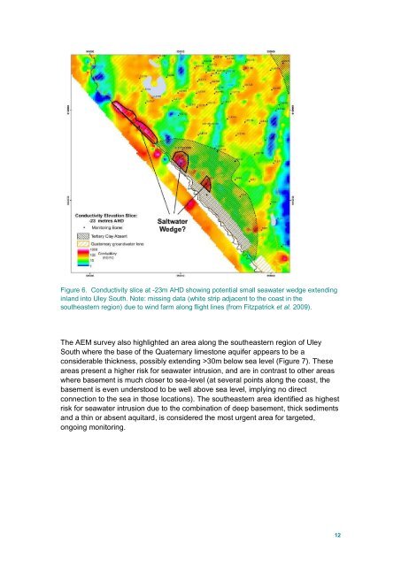
Figure 6. Conductivity slice at -23m AHD show<strong>in</strong>g potential small seawater wedge extend<strong>in</strong>g<br />
<strong>in</strong>land <strong>in</strong>to Uley South. Note: miss<strong>in</strong>g data (white strip adjacent to the coast <strong>in</strong> the<br />
southeastern region) due to w<strong>in</strong>d farm along flight l<strong>in</strong>es (from Fitzpatrick et al. <strong>2009</strong>).<br />
The AEM survey also highlighted an area along the southeastern region of Uley<br />
South where the base of the Quaternary limestone aquifer appears to be a<br />
considerable thickness, possibly extend<strong>in</strong>g >30m below sea level (Figure 7). These<br />
areas present a higher risk for seawater <strong><strong>in</strong>trusion</strong>, and are <strong>in</strong> contrast to other areas<br />
where basement is much closer to sea-level (at several po<strong>in</strong>ts along the coast, the<br />
basement is even understood to be well above sea level, imply<strong>in</strong>g no direct<br />
connection to the sea <strong>in</strong> those locations). The southeastern area identified as highest<br />
risk for seawater <strong><strong>in</strong>trusion</strong> due to the comb<strong>in</strong>ation of deep basement, thick sediments<br />
and a th<strong>in</strong> or absent aquitard, is considered the most urgent area for targeted,<br />
ongo<strong>in</strong>g monitor<strong>in</strong>g.<br />
12