Saltwater intrusion in Southern Eyre Peninsula, December 2009
Saltwater intrusion in Southern Eyre Peninsula, December 2009
Saltwater intrusion in Southern Eyre Peninsula, December 2009
You also want an ePaper? Increase the reach of your titles
YUMPU automatically turns print PDFs into web optimized ePapers that Google loves.
conditions expected <strong>in</strong> field sett<strong>in</strong>gs – a ”flux-controlled case”, and a ”head-controlled<br />
case”. Head-controlled boundaries may arise <strong>in</strong> situations where, for <strong>in</strong>stance, an<br />
<strong>in</strong>land water body (e.g. a canal, lake or wetland) of constant head occurs at the<br />
<strong>in</strong>land boundary of the model (e.g. <strong>in</strong> the case considered by Dausman and<br />
Langev<strong>in</strong>, 2005), or where pump<strong>in</strong>g occurs such that the <strong>in</strong>land head is constant<br />
despite sea-level rise. In Ward et al. (In Prep.), both flux-controlled and headcontrolled<br />
sett<strong>in</strong>gs are <strong>in</strong>vestigated further, however for the present study the fluxcontrolled<br />
boundary is considered to be the only relevant <strong>in</strong>land boundary condition.<br />
4.2.2 Dimensionless Formulation<br />
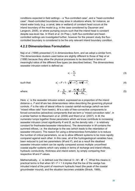
Naji et al. (1998) presented (1) <strong>in</strong> dimensionless form, and we adopt a similar form.<br />
The dimensionless clusters used below are slightly different to those of Naji et al.<br />
(1998) because they allow the physical processes to be described <strong>in</strong> terms of<br />
mean<strong>in</strong>gful ratios of the different flow types (as described below). The dimensionless<br />
seawater <strong><strong>in</strong>trusion</strong> extent is def<strong>in</strong>ed as<br />
x<br />
T<br />
x<br />
T<br />
(3)<br />
xi<br />
2<br />
such that: x T<br />
F 1 F 1 M F 1<br />
(4)<br />
where:<br />
q<br />
Rx<br />
i<br />
F ,<br />
i<br />
M<br />
K<br />
x<br />
i<br />
1<br />
q<br />
i<br />
B<br />
Rx<br />
i<br />
2<br />
(5)<br />
Here x<br />
T<br />
is the seawater <strong><strong>in</strong>trusion</strong> extent, expressed as a proportion of the <strong>in</strong>land<br />
distance x i . F and M are two dimensionless ratios describ<strong>in</strong>g the govern<strong>in</strong>g physical<br />
controls. F is the ratio of lateral <strong>in</strong>flow to coastal ra<strong>in</strong>fall-recharge (which we term<br />
“mixed <strong>in</strong>flow ratio” from here<strong>in</strong>). M is a ratio of free-convective components to<br />
forced-convective (advective) components that we term a “mixed convection ratio”, <strong>in</strong><br />
a similar fashion to Massmann et al. (2006) and Ward et al. (2007). In M, the<br />
numerator lumps together those parameters which we know contribute to <strong>in</strong>creas<strong>in</strong>g<br />
seawater <strong><strong>in</strong>trusion</strong> (most significantly K and B, as the density ratio is relatively<br />
constant for freshwater/seawater <strong>in</strong>teractions). The denom<strong>in</strong>ator <strong>in</strong> M conta<strong>in</strong>s the<br />
summed <strong>in</strong>flows, i.e. the discharge to the sea (which leads to the retardation of<br />
seawater <strong><strong>in</strong>trusion</strong>). The reason for us<strong>in</strong>g a dimensionless formulation is to reduce<br />
the number of critical parameters, so as to allow different systems to be more rapidly<br />
compared aga<strong>in</strong>st each other. In this case, all of the hydrogeological variables have<br />
been reduced to just two parameters (M and F), and as a result the idealised<br />
seawater <strong><strong>in</strong>trusion</strong> extent can be rapidly compared across multiple unconf<strong>in</strong>ed<br />
coastal aquifer systems which vary widely <strong>in</strong> terms of recharge and <strong>in</strong>land <strong>in</strong>flows,<br />
hydraulic conductivity, thickness and <strong>in</strong>land extent, by simply compar<strong>in</strong>g their<br />
respective M and F values.<br />
Mathematically, x<br />
T<br />
is def<strong>in</strong>ed over the <strong>in</strong>terval 0 M F 1 . What this means <strong>in</strong><br />
practical terms is that when M > F + 1 it implies that the toe of the wedge has<br />
<strong>in</strong>truded <strong>in</strong>land of the po<strong>in</strong>t of maximum hydraulic head (the peak of the coastal<br />
groundwater mound), and the situation becomes unstable (Strack, 1989).<br />
22


