Easy manual as pdf-file for download - Aircotec
Easy manual as pdf-file for download - Aircotec
Easy manual as pdf-file for download - Aircotec

You also want an ePaper? Increase the reach of your titles
YUMPU automatically turns print PDFs into web optimized ePapers that Google loves.
XC-Trainer<strong>E<strong>as</strong>y</strong> Manual _V8<br />
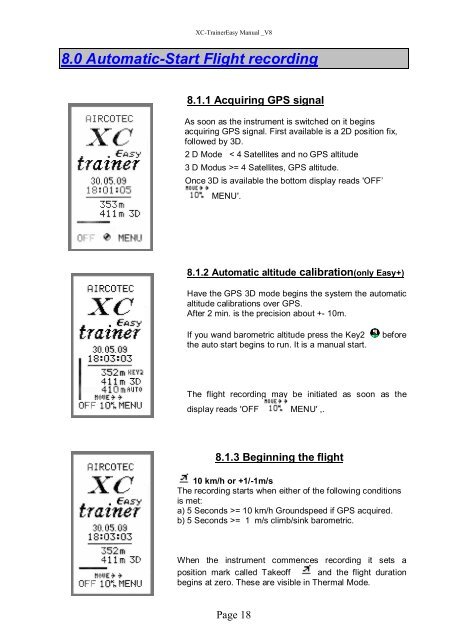
8.0 Automatic-Start Flight recording<br />
8.1.1 Acquiring GPS signal<br />
As soon <strong>as</strong> the instrument is switched on it begins<br />
acquiring GPS signal. First available is a 2D position fix,<br />
followed by 3D.<br />
2 D Mode < 4 Satellites and no GPS altitude<br />
3 D Modus >= 4 Satellites, GPS altitude.<br />
Once 3D is available the bottom display reads 'OFF’<br />
MENU'.<br />
8.1.2 Automatic altitude calibration(only <strong>E<strong>as</strong>y</strong>+)<br />
Have the GPS 3D mode begins the system the automatic<br />
altitude calibrations over GPS.<br />
After 2 min. is the precision about +- 10m.<br />
If you wand barometric altitude press the Key2<br />
the auto start begins to run. It is a <strong>manual</strong> start.<br />
be<strong>for</strong>e<br />
The flight recording may be initiated <strong>as</strong> soon <strong>as</strong> the<br />
display reads 'OFF MENU' ,.<br />
8.1.3 Beginning the flight<br />
10 km/h or +1/-1m/s<br />
The recording starts when either of the following conditions<br />
is met:<br />
a) 5 Seconds >= 10 km/h Groundspeed if GPS acquired.<br />
b) 5 Seconds >= 1 m/s climb/sink barometric.<br />
When the instrument commences recording it sets a<br />
position mark called Takeoff and the flight duration<br />
begins at zero. These are visible in Thermal Mode.<br />
Page 18