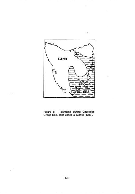
Figure 6. Tasmania during Cascades Group time, after Banks & Clarke (1987). • 46
equivalents of the Bonaparte succession in the Arafura Basin, for reasons given earlier, were probably also shallow marine. As this was a time of lowered sea levels in <strong>Australia</strong>, the Scott Plateau area was probably emergent. PERMIAN 4: LATE ARTINSKIAN - KUNGURIAN (266-258 Ma) The start of the interval was placed at an important sedimentation and environment change in eastern <strong>Australia</strong>, when dominantly terrestrial sedimentation was replaced by dominantly marine. It also corresponds to hiatuses in the Galilee Basin, Strathnnuir Synclinorium, northern Tasmania, and many parts of the Sydney - Bowen line of foreland basins, as well as marking the end of deposition at several sites. A chilling of the climate brought the local return of glaciation to western Victoria and the uplands along the western margin of the Sydney Basin. Evidence for this in Victoria comprises tillite and varved claystone (Bowen & Thomas, 1976), in a sequence which contains a palynological Stage 4 assemblage (Kemp & others, 1977). Alpine glaciers waxed amid spectacular 6000 m topography along the western Sydney Basin (Dulhunty, 1964), and these glaciers were the probable source of icebergs which rafted 4-5-tonne erratics into the marine Branxton Formation to the east, where dropstones were toppled onto a quiet sea floor, in places covered with the delicate fronds of the bryozoan Fenestella (David, 1907). Conspicuous by its absence is the great Ayr Volcanic Rift, where volcanism had by now ended. Extant eruptive activity was confined to the basic-andesitic submarine outpourings in the Yarrol Basin, minor submarine andesite in the Gympie Terrane, felsic to mafic volcanism in northeastern New England, and at least partly subaerial rhyolitic eruptions in the Yarraman block west of Brisbane. The time slice was a period of renewed marine transgression in many basins. In Tasmania, the sea at first advanced towards the north and west as two lobes (Fig. 6), during Cascades Group time (Banks & Clarke, 1987; Clarke, 1989). Later in the interval, after a hiatus had interrupted deposition in all but the easternmost parts of the basin, inundation overwhelmed the eastern half of the state, and eventually reached as far west as the present west coast in the vicinity of Strahan. The greatest subsidence and sedimentation was in a trough along the Tamar Fracture System, with sediment feeding in from source areas lying to the southwest, northwest, and northeast, at different times (Banks & Clarke, 1987). The sequences contain coldwater faunas, dropstones presumably carried in by seasonal ice, and limestones. The average sea water temperature of -1.8°C was comparable to that for the present day Antarctic shelf (Rao & Green, 1982). An apron of coalescing fan deltas, constructed south of a rising hinterland, formed a prograding coastline in the northern Sydney Basin early in the period, while a similar line of alluvial fans and distal alluvial plains extended northwesterly, into the Gunnedah Basin. The latter was divided into two sub-basins by the Boggabri Ridge. Peat, aggrading in raised bogs on the fan surfaces, gave rise to the important seams of the 47
- Page 1 and 2: BMR RECORD 1990/60 PAUEOGEOGRAPHY 1
- Page 3 and 4: PERMIAN ENERGY & MINERAL RESOURCES^
- Page 5 and 6: FOREWORD Palmogeographic maps are o
- Page 7 and 8: were then used to determine the sed
- Page 9 and 10: Oil); L.G. Elliott, P.L. Price, and
- Page 11 and 12: sequences underlying parts of the S
- Page 13 and 14: Eurydesma occurrences, suggesting t
- Page 15 and 16: that the Lynningtonian stage embrac
- Page 17 and 18: is constrained by the presence in p
- Page 19 and 20: Permian igneous activity in the Per
- Page 21 and 22: the late Artinskian and the basin w
- Page 23 and 24: the Permian, however, the Permo-Car
- Page 25 and 26: sea level; the only documented Perm
- Page 27 and 28: southern Sydney Basin have been rel
- Page 29 and 30: Connors-Auburn Volcanic Arc (Day &
- Page 31 and 32: NEW ENGLAND OROGEN Yarrol Province
- Page 33 and 34: ^ 300 Ma CURTIS ISLAND TERRANE 302
- Page 35 and 36: • WARWICK KILOMETRES 0^20^40^60 0
- Page 37 and 38: existence of the fault. DISCUSSION
- Page 39 and 40: Figure 5. Australia's position in G
- Page 41 and 42: would alone occupy an entire volume
- Page 43 and 44: the map), perhaps being joined by c
- Page 45 and 46: Extensive bodies of marine water oc
- Page 47 and 48: e attributed to the higher sea leve
- Page 49: The marine region of eastern New En
- Page 53 and 54: Figure 7. Eastern Australian palmog
- Page 55 and 56: ocks at all of Permian 4 age, could
- Page 57 and 58: others, 1985). Granitic intrusion a
- Page 59 and 60: history of upper delta plain facies
- Page 61 and 62: Basins were sourced from the underl
- Page 63 and 64: structure in this area, ideally sui
- Page 65 and 66: The Pedirka Basin's petroleum prosp
- Page 67 and 68: side of the outcropping portion of
- Page 69 and 70: Murray Infra-basins and Oaklands Ba
- Page 71 and 72: as they were infilled; a hiatus occ
- Page 73 and 74: Permian Alum Mountain Volcanics, in
- Page 75 and 76: to the end of the period (Fig. 8).
- Page 77 and 78: SELECTED BIBLIOGRAPHY ALLCHURCH, P.
- Page 79 and 80: BANKS, M.R., & AHMAD, N., 1962 - Th
- Page 81 and 82: BLACK, L.P., BLAKE, D.H., & OLATUNJ
- Page 83 and 84: Resources, Australia, Record 1990/6
- Page 85 and 86: BROWN LOW, J.W., 1982a - A time-spa
- Page 87 and 88: E.L. (Editors) - Geology and minera
- Page 89 and 90: in New England, New South Wales. Jo
- Page 91 and 92: Metallogeny and tectonic developmen
- Page 93 and 94: Lochinvar Formation of the Sydney B
- Page 95 and 96: EXON, N.F., 1974 - The geological e
- Page 97 and 98: GSQ Mundubbera 5 & 6, Taroom Trough
- Page 99 and 100: GULSON, B.L., DIESSEL, C.F.K., MASO
- Page 101 and 102:
HAWKINS, P.J., 1976 - Facies analys
- Page 103 and 104:
HOLCOMBE, R.J., LITTLE, T.A., GIBSO
- Page 105 and 106:
JONES, P.J., 1988 - Comments on som
- Page 107 and 108:
to basin development across Phanero
- Page 109 and 110:
LE MAITRE, R.W., 1975 - Volcanic ro
- Page 111 and 112:
MALONE, E.J., JENSEN, A.R., GREGORY
- Page 113 and 114:
McPHIE, J., 1982 - The Coombadjha V
- Page 115 and 116:
MORY, A.J., 1988 - Regional geology
- Page 117 and 118:
OLGERS, F., WEBB, A.W., SMIT, J.A.J
- Page 119 and 120:
Geological Survey of New South Wale
- Page 121 and 122:
Bonaparte Gulf Basin 1963-71. Burea
- Page 123 and 124:
Basin, central Queensland. Geologic
- Page 125 and 126:
TINGATE, P.R., ANDREW, J.W., DUDDY,
- Page 127 and 128:
VOISEY, A.H., & PACKHAM, G.H., 1969
- Page 129 and 130:
WILFORD, G.E., 1983 - Phanerozoic p
- Page 131:
ENVIRONMENT SYMBOLS ON PERMIAN INTE