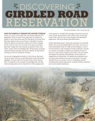
GIRDLED ROAD RESERVATION - Lake Metroparks
GIRDLED ROAD RESERVATION - Lake Metroparks
GIRDLED ROAD RESERVATION - Lake Metroparks

Create successful ePaper yourself
Turn your PDF publications into a flip-book with our unique Google optimized e-Paper software.
ail<br />
il<br />
ail<br />
il<br />
r ail<br />
r ail<br />
ail<br />
r ail<br />
ail<br />
r ail<br />
ail<br />
ail<br />
r ail<br />
r ail<br />
ail<br />
Y 100<br />
K 20<br />
Valley View Overlook Tr ail<br />
C 60<br />
Trail Descriptions<br />
M 62<br />
Y 11<br />
Oak Leaf Loop Tr ail<br />
Green Darner Tr ail<br />
<strong>Lake</strong> <strong>Metroparks</strong> has K 0 planned and developed trails that<br />
provide public access to unique cultural and natural<br />
resource features of the park. The park system strives<br />
Valley View Overlook Tr ail<br />
C 35<br />
to create an opportunity for the public to develop a<br />
M 0<br />
greater understanding of <strong>Lake</strong> County and its natural<br />
Y 31<br />
environment. K 0<br />
Field View Tr ail<br />
C 0<br />
M 62<br />
Y 100<br />
K 23<br />
Big Creek Valley Trail<br />
Green Darner Tr ail<br />
C 100<br />
M 83<br />
Y 31<br />
K 29<br />
C 59<br />
M 63<br />
Y 100<br />
K 4<br />
Chickadee Tr ail<br />
Access: Radcliffe Rd. parking lot trailhead<br />
Field View Tr ail<br />
C 34<br />
M 100<br />
Permitted Uses: Hike<br />
Length: 0.43-mile trail<br />
Y C 57 57<br />
M 17<br />
Y 29<br />
K 60<br />
Surveyors Woods Loop Tr ail<br />
Surface: Natural K 39<br />
Oak Leaf Loop Tr ail<br />
This creek-side trail provides picture perfect views<br />
Chickadee Tr ail<br />
of Big Creek and C the 0 hemlock ravines that feed it.<br />
Big Creek, which<br />
M<br />
begins<br />
74<br />
as a small stream near<br />
Y 100<br />
Chardon, joins the<br />
K<br />
Grand<br />
0<br />
River at Helen<br />
Valley<br />
Big<br />
View<br />
Creek Hazen<br />
Overlook<br />
Valley<br />
Tr<br />
Tr<br />
ail<br />
ail<br />
Wyman Park in Painesville.<br />
C 26<br />
M 92<br />
Y 100<br />
K 20<br />
C 12<br />
M 24<br />
Y C 100 60<br />
K M 0 62<br />
Y 11<br />
K 0<br />
Surveyors Woods Loop Tr ail<br />
Chickadee Trail<br />
Skok Meadow Loop Tr ail<br />
Green Darner Tr ail<br />
Big Creek Valley Tr ail<br />
Access: Girdled Rd. parking lot trailhead<br />
C 35<br />
Permitted Uses: Hike M 0<br />
Hawthorne Tr ail<br />
Length: 0.68-mile Y trail 31<br />
Field View Tr ail<br />
Surface: Compacted K 0 gravel<br />
Skok Meadow Loop Tr ail<br />
Follow the chickadees through the hemlock trees<br />
as the trail winds down to a bridge, over Big Creek,<br />
and up to join with Oak Leaf Loop Trail.<br />
Goldenrod Chickadee Tr ail<br />
Hawthorne Tr ail<br />
C 34<br />
M 100<br />
Y 57<br />
K 39<br />
Surveyors Woods Loop Tr ail<br />
Goldenrod Tr ail<br />
C 0<br />
M 63<br />
Y 100<br />
K 4<br />
C 0<br />
M 62<br />
Y 100<br />
K 23<br />
Green Darner Trail<br />
C 57<br />
M 17<br />
Y 29<br />
K 60<br />
C 59<br />
M 63<br />
Y 100<br />
K 4<br />
Chickadee Tr ail<br />
Surveyors Woods Loop Tr ail<br />
Access: Radcliffe Rd. parking lot trailhead<br />
C 26<br />
Permitted Uses: Hike M 92<br />
Length: 0.33-mile Y trail 100<br />
Big Creek Valley Tr ail<br />
Surface: Compacted K 20 gravel<br />
C 57<br />
M 17<br />
Y 29<br />
K 60<br />
This trail circles a man-made wetland which<br />
attracts ducks and other water birds all year. Enjoy<br />
a peaceful view on a park bench or scout for frogs<br />
Skok Meadow Loop Tr ail<br />
along the edge.<br />
C 26<br />
Oak Leaf Loop Tr ail<br />
C 60<br />
M 62<br />
Y 11<br />
K 0<br />
M 92<br />
Y 100<br />
K 20<br />
Oak Leaf Loop Trail<br />
C 35<br />
M 0<br />
C 0<br />
Y M 31 62<br />
K Y 0 100<br />
K 23<br />
C 60<br />
M 62<br />
Y 11<br />
K 0<br />
Valley View Hawthorne Overlook Tr Tr ail ail<br />
C 100<br />
M 83<br />
Y 31<br />
K 29<br />
Access: Radcliffe Rd. parking lot trailhead<br />
C 59<br />
Permitted Uses: Hike,<br />
M 63<br />
bike, horse<br />
Length: 4.09-mile loop trail<br />
Goldenrod Tr ail<br />
C Y 100 35<br />
Green Darner Tr ail<br />
Surface: Compacted M K 4 0 gravel<br />
Y 31<br />
C 100<br />
M 83<br />
Y 31<br />
K 29<br />
This moderate to strenuous K 0 hike runs through<br />
C 34<br />
large sections of forest,<br />
M 100<br />
57 down along Big Creek, and<br />
back. The shorter loop Y 57<br />
17 trail takes hikers through<br />
the upland sections K 39<br />
29<br />
of the park where some Field of the<br />
60<br />
View Tr ail<br />
largest trees in this park can be observed.<br />
C 0<br />
M 74<br />
Y 100<br />
K 0<br />
C 26<br />
M 92<br />
Y 100<br />
K 20<br />
Skok Meadow Loop<br />
C 34<br />
Trail M 100<br />
Y 57<br />
K 39<br />
C 12<br />
M 24<br />
Y 100<br />
C 60<br />
M 62<br />
Y 11<br />
K 0<br />
Chickadee Tr ail<br />
Access: Concord-Hambden Surveyors Rd. parking Woods lot trailhead Loop Tr ail<br />
C 0<br />
Permitted Uses: Hike M K 0 74<br />
Length: 1.09-mile Y loop 100 trail<br />
Surface: Compacted K 0 gravel<br />
C 35<br />
M 0<br />
Y 31<br />
K 0<br />
Enjoy this restored meadow, abundant in native<br />
plants and wildflowers. Two observation Big decks Creek offer Valley Tr ail<br />
C 12<br />
scenic views of the landscape and creek valley.<br />
M 24<br />
Y 100<br />
K 0<br />
M 62<br />
Y 11<br />
K 0<br />
Surveyor’s Woods<br />
Loop Trail<br />
C 35<br />
M 0<br />
Y 31<br />
K 0<br />
Access: Girdled Rd. parking lot trailhead<br />
Permitted Uses: Hike, bike, horse<br />
Length: 1.22-mile loop trail<br />
Surface: Compacted gravel<br />
Led by Simon Perkins, the first surveyors and<br />
builders of Girdled Road established a base camp<br />
C 34<br />
M 100<br />
not far from here in 1798. This upland trail explores<br />
Y 57<br />
the ridge above Big Creek and surrounding woodlot.<br />
C 0<br />
M 62<br />
K Y 39 100<br />
K 23<br />
Valley View Overlook<br />
Trail<br />
C 0<br />
M 74<br />
Y 100<br />
K 0<br />
C 59<br />
M 63<br />
Y 100<br />
K 4<br />
Access: Girdled Rd. C C 12 parking 57 lot trailhead<br />
Permitted Uses: Hike<br />
M 24 17<br />
Y<br />
Length: 0.07-mile Y 100<br />
trail 29<br />
K K 0 60<br />
Surface: Compacted gravel<br />
The best view in the county overlooking Big Creek<br />
Valley and the forests that protect it.<br />
C 26<br />
M 92<br />
Y 100<br />
K 20<br />
The Buckeye Trail<br />
The Buckeye trail is the first and only long distance<br />
hiking trail located C entirely 60 within Ohio. It circles<br />
M 62<br />
throughout the state traversing over 40 of the 88<br />
Y 11<br />
counties. Just look K for 0 the blue blazes. For more<br />
information go to www.buckeyetrail.org.<br />
C 35<br />
M 0<br />
Y 31<br />
Trail advisories, notes, cautions<br />
As with any outdoor activity,<br />
K 0<br />
there are inherent risks with<br />
hiking, biking and horseback riding. It is <strong>Lake</strong> <strong>Metroparks</strong>’<br />
intention to manage trails to minimize risks based on the<br />
challenges associated with the activities appropriate for that<br />
particular trail. We will work to communicate the various levels<br />
of physical challenges and natural conditions existing within<br />
the trail system.<br />
C 100<br />
M 83<br />
Y 31<br />
K 29