Chagrin River Park - Lake Metroparks
Chagrin River Park - Lake Metroparks
Chagrin River Park - Lake Metroparks

You also want an ePaper? Increase the reach of your titles
YUMPU automatically turns print PDFs into web optimized ePapers that Google loves.
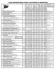
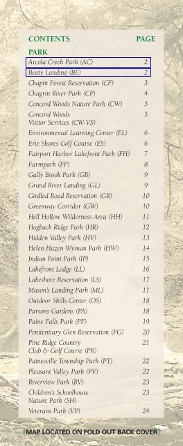
CONTENTS<br />
PAGE<br />
PARK<br />
Arcola Creek <strong>Park</strong> (AC) 2<br />
Beaty Landing (BE) 2<br />
Chapin Forest Reservation (CF) 3<br />
<strong>Chagrin</strong> <strong>River</strong> <strong>Park</strong> (CP) 4<br />
Concord Woods Nature <strong>Park</strong> (CW) 5<br />
Concord Woods 5<br />
Visitor Services (CW-VS)<br />
Environmental Learning Center (EL) 6<br />
Erie Shores Golf Course (ES) 6<br />
Fairport Harbor <strong>Lake</strong>front <strong>Park</strong> (FH) 7<br />
Farmpark (FP) 8<br />
Gully Brook <strong>Park</strong> (GB) 9<br />
Grand <strong>River</strong> Landing (GL) 9<br />
Girdled Road Reservation (GR) 10<br />
Greenway Corridor (GW) 10<br />
Hell Hollow Wilderness Area (HH) 11<br />
Hogback Ridge <strong>Park</strong> (HR) 12<br />
Hidden Valley <strong>Park</strong> (HV) 13<br />
Helen Hazen Wyman <strong>Park</strong> (HW) 14<br />
Indian Point <strong>Park</strong> (IP) 15<br />
<strong>Lake</strong>front Lodge (LL) 16<br />
<strong>Lake</strong>shore Reservation (LS) 17<br />
Mason’s Landing <strong>Park</strong> (ML) 17<br />
Outdoor Skills Center (OS) 18<br />
Parsons Gardens (PA) 18<br />
Paine Falls <strong>Park</strong> (PF) 19<br />
Penitentiary Glen Reservation (PG) 20<br />
Pine Ridge Country 21<br />
Club & Golf Course (PR)<br />
Painesville Township <strong>Park</strong> (PT) 22<br />
Pleasant Valley <strong>Park</strong> (PV) 22<br />
<strong>River</strong>view <strong>Park</strong> (RV) 23<br />
Children’s Schoolhouse 23<br />
Nature <strong>Park</strong> (SH)<br />
Veterans <strong>Park</strong> (VP) 24<br />
[MAP LOCATED ON FOLD OUT BACK COVER]
Arcola Creek <strong>Park</strong> (AC)<br />
941 DOCK ROAD, MADISON TWP., OH 44057<br />
DIRECTIONS [MAP COORDINATES: A15]<br />
Take Rt. 20 to Dock Road. Go north for 3.5 miles. Arcola<br />
Creek <strong>Park</strong> is located on the right (east).<br />
Arcola Creek Estuary is a place where the fresh waters of<br />
the creek mix with the waves of <strong>Lake</strong> Erie.<br />
It is one of the last remaining natural<br />
estuaries in Ohio. Steelhead trout<br />
spawn and migratory birds find shelter<br />
here.<br />
HOURS: Daylight to 1/2 hour after<br />
sunset.<br />
AMENITIES: 153 acres. Picnic area. Portable<br />
restrooms. Fishing. Observation deck. Access to<br />
<strong>Lake</strong> Erie shoreline.<br />
Beaty Landing (BE)<br />
417 EAST WALNUT STREET (RT. 84)<br />
PAINESVILLE, OH 44077<br />
DIRECTIONS [MAP COORDINATES: G9]<br />
Take Rt. 2 to Richmond Road and go south. Turn left<br />
(east) onto East Walnut Avenue. Beaty Landing is<br />
located on the left (south).<br />
This 54-acre wooded parcel in Painesville encompasses<br />
3,300 feet of frontage on the Grand <strong>River</strong>. This park is<br />
home to Grand <strong>River</strong> valley wildlife and is within walking<br />
distance for the residents of Painesville City.<br />
HOURS: Sunrise to sunset.<br />
AMENITIES: 54 acres. Picnic area. Restrooms.<br />
One mile hiking trail. Fishing. Overlook deck.<br />
2
Chapin Forest Reservation (CF)<br />
10090 CHILLICOTHE ROAD (RT. 306)<br />
10381 HOBART ROAD, KIRTLAND, OH 44094<br />
PINE LODGE NATURE DAY CAMP & SKI CENTER:<br />
(440) 256-3810<br />
DIRECTIONS [MAP COORDINATES: N4, N5]<br />
RT. 306 ENTRANCE: Take I-90 to Rt. 306. Go south<br />
approximately 3 miles. Chapin Forest Reservation<br />
is located on the right (west).<br />
HOBART RD. ENTRANCE: Take I-90 to Rt. 306<br />
south. Go 5 miles and turn right (west) onto<br />
Chardon Road (Rt. 6). Go 1 mile and turn right<br />
(north) onto Hobart Road. Go .5 mile to the park<br />
entrance located on the right (east).<br />
The 390 acres of Chapin Forest Reservation are known<br />
for distinctive rock formations and majestic forests.<br />
Wander through miles of mature woodland trails<br />
comprised of beech, maple, oak, tulip and hemlock. Stop<br />
by Quarry Pond and walk Lucky Stone Loop Trail.<br />
The Pine Lodge at the Hobart Road entrance features a<br />
cross-country ski center complete with ski rental<br />
equipment and lessons, groomed ski trails, snowshoe<br />
rental and fireplace. Open, weather permitting, from<br />
approximately November 15 to March 15.<br />
HOURS: Daylight to 1/2 hour after sunset.<br />
AMENITIES: 390 acres. Four picnic areas and<br />
shelters with grills. Drinking water. Restrooms.<br />
Playground. Pond fishing. Ball/game fields. Limited<br />
bridle trails. Cross-country skiing.<br />
SHELTER RENTAL: (440) 358-7275<br />
3
<strong>Chagrin</strong> <strong>River</strong> <strong>Park</strong> (CP)<br />
3100 REEVES ROAD, WILLOUGHBY, OH 44094<br />
DIRECTIONS [MAP COORDINATES: K3]<br />
Take Rt. 2 to Lost Nation Road and go north.Turn<br />
left (west) onto Reeves Road. <strong>Chagrin</strong> <strong>River</strong> <strong>Park</strong><br />
is located on the left (south).<br />
ADDITIONAL<br />
ENTRANCES:<br />
37699 Erie Road,<br />
Willoughby, OH 44094<br />
1000 Rural Drive,<br />
Eastlake, OH 44095<br />
<strong>Park</strong> land on the east and<br />
west banks of the <strong>Chagrin</strong><br />
<strong>River</strong> is linked by a<br />
pedestrian bridge. Access is provided to more than 2.83<br />
miles of trails. <strong>Chagrin</strong> <strong>River</strong> <strong>Park</strong> is a great place to see<br />
great blue herons, kingfishers, bank swallows and<br />
sandpipers near the river. Two wetland areas support<br />
frogs, salamanders and a variety of songbirds. The<br />
seasonal wetland near the picnic shelter serves as a haven<br />
for mallards and blue-winged teal. Most of the park’s<br />
natural areas are made up of dense shrubs with pockets<br />
of mature forest bordering wetland areas.<br />
HOURS: Daylight to 1/2 hour after sunset.<br />
AMENITIES: 227 acres. Picnic area with grills.<br />
Picnic shelters. Drinking water. Restrooms. Hiking<br />
trails. Playground. Volleyball court. Fishing.<br />
Sledding hill. Ball/game fields. Pay phone.<br />
SHELTER RENTAL: (440) 358-7275<br />
4
Concord Woods Nature <strong>Park</strong> (CW)<br />
11211 SPEAR ROAD, CONCORD TWP., OH 44077<br />
ADMINISTRATIVE OFFICES: (440) 639-7275<br />
DIRECTIONS [MAP COORDINATES: J8]<br />
Take I-90 to Rt. 44 and go south. Turn left (north)<br />
onto Auburn Road. Turn right (east) onto Spear<br />
Road.<br />
Concord Woods is a 31-acre park featuring a hiking trail,<br />
picnic area, shelter and stocked fishing area.<br />
HOURS: Daylight to 1/2 hour after sunset.<br />
AMENITIES: 31 acres. Picnic area. Shelter with<br />
fireplace and grills. Drinking water. Restrooms.<br />
Hiking trails. Playground.<br />
SHELTER RENTAL: (440) 358-7275<br />
LAKE METROPARKS ADMINISTRATIVE OFFICES:<br />
Located at the entrance of the park on the right.<br />
HOURS: 8:00 am to 4:30 pm, Monday – Friday.<br />
Concord Woods Visitor Services<br />
(Registration Department and<br />
Ranger Headquarters) (CW-VS)<br />
11189 SPEAR ROAD, CONCORD TWP., OH 44077<br />
REGISTRATION DEPT: (440) 358-7275 • 800-669-9226<br />
RANGER DEPT: (440) 358-7290<br />
DIRECTIONS [MAP COORDINATES: J8]<br />
Take I-90 to Rt. 44 and go south. Turn left (north)<br />
onto Auburn Road. Turn right (east) onto Spear<br />
Road.<br />
REGISTRATION DEPARTMENT HOURS:<br />
8:00 am to 4:30 pm, Monday – Friday.<br />
RANGER DEPARTMENT HOURS:<br />
8:00 am to 4:00 pm, Monday – Friday and by<br />
appointment.<br />
5
Environmental Learning Center (EL)<br />
7200 ALEXANDER ROAD, CONCORD TWP., OH 44077<br />
(440) 354-0894<br />
[MAP COORDINATES: J9]<br />
The <strong>Lake</strong> <strong>Metroparks</strong> Environmental Learning Center is<br />
a state-of-the-art educational facility that connects people<br />
with nature. It features educational exhibits, fully<br />
equipped high-tech classrooms, an astronomical<br />
observatory, a biology/biotechnology lab and a weather<br />
station.<br />
HOURS: Open for pre-registered programs only.<br />
Erie Shores Golf Course (ES)<br />
7298 LAKE ROAD EAST, MADISON TWP., OH 44057<br />
(440) 428-3164 • 800-225-3742<br />
DIRECTIONS [MAP COORDINATES: B15]<br />
Take Rt. 20 to Bennett Road and go north for 3<br />
miles. Turn right (east) onto <strong>Lake</strong> Road. Erie<br />
Shores Golf Course is .3 mile on the right (south).<br />
Erie Shores features a beautiful 18-hole course designated<br />
as a Backyard Wildlife Habitat by the National Wildlife<br />
Federation. Recent improvements include the redesign of<br />
hole 1 and installation of a full irrigation system. The<br />
course features a clubhouse, pro shop, snack shop, patio<br />
and shelter. It also offers a driving range and<br />
instructional center with target greens, practice bunkers,<br />
plus chipping, pitching and putting greens. A PGA<br />
professional is on staff for advice and lessons. Leagues<br />
and catered outings are also available.<br />
HOURS: Sunrise to sunset<br />
AMENITIES: 190 acres. Concessions. Drinking<br />
water. Restrooms. Pay phone.<br />
6
Fairport Harbor <strong>Lake</strong>front <strong>Park</strong><br />
(FH)<br />
301 HUNTINGTON BEACH DRIVE<br />
FAIRPORT HARBOR, OH 44077<br />
(440) 639-9972 (SUMMER ONLY)<br />
DIRECTIONS [MAP COORDINATES: E7]<br />
Take Rt. 2 to the Fairport Harbor/Richmond Street<br />
exit and go north. Proceed north (straight) to High<br />
Street. Turn right onto High Street and proceed to<br />
Fairport Harbor <strong>Lake</strong>front <strong>Park</strong><br />
entrance.<br />
This 21-acre lakefront park<br />
located in historic Fairport<br />
Harbor features one of the finest<br />
beaches of protected waters on <strong>Lake</strong><br />
Erie, with gradual slope and sandy<br />
bottom. Recreational opportunities on the waterfront<br />
include kayaking, canoeing, sailing, boating, camps and<br />
special beach programs/festivals.<br />
HOURS: The park is open year-round daylight to<br />
1/2 hour after sunset.<br />
The beach opens Memorial Day Weekend and is<br />
open daily through Labor Day Weekend, sunrise<br />
to sunset. Lifeguards are on duty and the<br />
concession stand is open from 10 am to 8 pm,<br />
weather dependent.<br />
PARKING: A parking fee applies. Season parking<br />
passes are available. <strong>Lake</strong> County residents<br />
receive a discount.<br />
AMENITIES: 21 acres. Restrooms. Changing<br />
rooms and shower facilities. Picnic area with<br />
shelter and grills. Playground. Volleyball courts.<br />
Drinking fountain. Fishing access.<br />
7
Farmpark (FP)<br />
8800 CHARDON ROAD, KIRTLAND, OH 44094<br />
(440) 256-2122 • 800-366-FARM<br />
DIRECTIONS [MAP COORDINATES: O6]<br />
Take 1-90 to Rt. 306. Go south 5 miles to Chardon<br />
Road (Rt. 6). Turn left (east) onto Chardon Road<br />
for 1 mile. Farmpark is on the right.<br />
Spend a day at the award-winning, 235-acre Farmpark,<br />
a hands-on family fun science and cultural center. Milk a<br />
cow. Take a horse- or tractor-drawn wagon ride. See<br />
more than 50 breeds of farm animals (livestock) and<br />
enjoy many special events. Explore plant life at the Plant<br />
Science Center’s themed gardens, The Great Tomato<br />
Works and hydroponics exhibits. Discover how wind and<br />
solar power are harvested. Enjoy a<br />
country lunch or snack and visit the<br />
Farmpark Gift Shop for unique<br />
gift ideas.<br />
ADMISSION:<br />
Fee applies; call for<br />
current rates. Free parking.<br />
Younger than 2 years: Free<br />
Farmpark Members: Free<br />
HOURS: Open 9 am to 5 pm year-round.<br />
Closed Thanksgiving, Christmas and New Year’s<br />
Day. Closed Mondays January through March.<br />
Open M.L. King, Jr. Day and Presidents’ Day.<br />
SHELTER AND FACILITY RENTAL: (440) 256-2138<br />
8
Gully Brook <strong>Park</strong> (GB)<br />
RIVER ROAD/RIDGE ROAD<br />
WILLOUGHBY/WILLOUGHBY HILLS, OH<br />
[MAP COORDINATES: M3]<br />
Gully Brook is one of the last large vestiges of open space<br />
in western <strong>Lake</strong> County and its preservation is considered<br />
to be one of the most important components for protecting<br />
the <strong>Chagrin</strong> <strong>River</strong> watershed.<br />
<strong>Lake</strong> <strong>Metroparks</strong> is in the process of developing a<br />
strategic operating plan for the future use of this park.<br />
Opening projected in 2010; check lakemetroparks.com<br />
for updates.<br />
Grand <strong>River</strong> Landing (GL)<br />
800 N. ST. CLAIR STREET, FAIRPORT HARBOR, OH 44077<br />
DIRECTIONS [MAP COORDINATES: F7]<br />
Take Rt. 2 to the Fairport Harbor/Richmond Street<br />
exit and go north. Turn right onto East Street<br />
(Rt. 535) and proceed to St. Clair Street; turn<br />
right. Proceed to Grand <strong>River</strong> Landing entrance<br />
on south side of road just before bridge.<br />
This park provides small boat access (canoe and kayak) to<br />
the Grand <strong>River</strong> and <strong>Lake</strong> Erie. Low bridges across the river<br />
limit the size and types of boating on this river section.<br />
Fishing is popular along the banks of the river.<br />
HOURS: Daylight to 1/2 hour after sunset.<br />
AMENITIES: 15 acres. Small boat launch facility.<br />
Picnic tables. Seasonal restrooms. Fishing.<br />
9
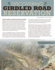
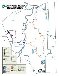
Girdled Road Reservation (GR)<br />
NORTH ENTRANCE: 12898 GIRDLED ROAD<br />
SOUTH ENTRANCE: 12899 RADCLIFFE ROAD<br />
CONCORD TWP., OH 44077<br />
DIRECTIONS [MAP COORDINATES: K10]<br />
NORTH:Take I-90 to Rt. 44 south and travel 1.5 miles to<br />
Girdled Road.Turn left (east) onto Girdled Road and<br />
travel for 3.5 miles. Proceed to Girdled Road<br />
Reservation, on the right (south).<br />
SOUTH: Take I-90 to Rt. 44 south.Turn left (east) onto<br />
Girdled Road and travel 2.5 miles.Turn right (south)<br />
onto Rt. 608 and travel 2 miles.Turn left (east) onto<br />
Radcliffe Road and drive .3 mile. Proceed to Girdled<br />
Road Reservation, located on the left (north).<br />
Visitors can experience the beauty of dense forests, fields<br />
and wetlands. Audubon Ohio has designated this park as<br />
an Important Bird Area.<br />
HOURS: Daylight to 1/2 hour after sunset.<br />
AMENITIES: 932 acres. Picnic areas with grills. Picnic<br />
shelter (south). Drinking water (north). Restrooms.<br />
Hiking trails. Playground (south park only). Fishing.<br />
Cross-country skiing. Ball/game fields.<br />
SHELTER RENTAL: (440) 358-7275<br />
Greenway Corridor (GW)<br />
PAINESVILLE • PAINESVILLE TWP. • CONCORDTWP.<br />
[MAP COORDINATES: I8]<br />
PARKING AREAS: Rt. 84 & Liberty Street.,<br />
7121 Ravenna Road & 7565 Ravenna Road<br />
The Baltimore and Ohio Railroad, founded in 1827, has paved<br />
the way for the Greenway Corridor – a bustling bike and hike<br />
trail replacing the historic railroad. Sounds of bicycle wheels<br />
and happy walkers replace train whistles and the clattering of<br />
tracks as one travels on the 4.8-mile paved trail. This corridor<br />
links Painesville, Painesville Township and Concord Township,<br />
allowing visitors to enjoy the natural beauty of these<br />
communities in a safe environment. Travelers cross bridges and<br />
experience varied levels of terrain with a 240-ft. drop in<br />
elevation from Concord Township to Painesville City.<br />
HOURS: Daylight to 1/2 hour after sunset.<br />
10
Hell Hollow Wilderness Area (HH)<br />
14435 LEROY CENTER ROAD, LEROY TWP., OH 44077<br />
DIRECTIONS [MAP COORDINATES: I 12]<br />
Take I-90 to Vrooman Road and go south for .5<br />
mile to Carter Road. Turn left (east) and continue<br />
for 2 miles to Paine Road and turn left (north).<br />
Proceed north on Paine Road to Blair Road. Take<br />
Blair Road (east). Travel 1 mile to Ford Road and<br />
turn right (east) and proceed 1 mile to Trask Road<br />
and turn right (south). Continue south on Trask<br />
Road to Brockway Road. Follow Brockway for 1<br />
mile. It ends at Leroy Center Road. Turn right into<br />
Hell Hollow Wilderness Area.<br />
Hell Hollow Wilderness Area has a high cliff top with a<br />
loop trail and 262 timber steps that provide a dramatic<br />
descent to the creek valley. The more than 100-foot-deep<br />
ravine was carved thousands of years ago by Paine Creek<br />
after glaciers retreated from Ohio. This park offers<br />
impressive views of the 360 million year-old <strong>Chagrin</strong><br />
Shale cliff above a deep river valley. Audubon Ohio has<br />
designated this park as an Important Bird Area.<br />
HOURS: Daylight to 1/2 hour after sunset.<br />
AMENITIES: 783 acres. Picnic area with grills.<br />
Picnic shelter. Restrooms. Hiking trails.<br />
Playground. Ball/game fields.<br />
11
Hogback Ridge <strong>Park</strong> (HR)<br />
SOUTH ENTRANCE 4888 EMERSON ROAD<br />
NORTH ENTRANCE: 7300 WARNER ROAD<br />
MADISON TWP., OH 44057<br />
DIRECTIONS [MAP COORDINATES: F15]<br />
Take I-90 to Rt. 528 and go south for 2 miles.Turn<br />
left (east) onto Griswold Road. Proceed for 1 mile<br />
and turn left (north) onto Emerson Road for .5<br />
mile to Hogback Ridge <strong>Park</strong>.<br />
Hogback Ridge <strong>Park</strong> is named for<br />
its most prominent natural<br />
feature: a high, narrow ridge of<br />
land bounded on two sides by<br />
steep valleys. This type of ridge<br />
is named for its resemblance to<br />
the bony spine of a hog. The 414<br />
acres of Hogback Ridge <strong>Park</strong><br />
include upland hardwood forests,<br />
hemlock ridges and the floodplains of Mill Creek and the<br />
Grand <strong>River</strong>.<br />
HOURS: Daylight to 1/2 hour after sunset.<br />
AMENITIES: 414 acres. Picnic area with grills.<br />
Picnic shelter. Restrooms. Hiking trails. Fishing.<br />
Cabin.<br />
CABIN RENTAL: (440) 358-7275<br />
12
Hidden Valley <strong>Park</strong> (HV)<br />
SOUTH ENTRANCE: 4880 KLASEN ROAD<br />
RESOURCE CENTER: 4837 PALISADES DRIVE<br />
MADISON TWP., OH 44057<br />
DIRECTIONS [MAP COORDINATES: F14]<br />
Take I-90 to Rt. 528 south for 1.5 miles. Turn right<br />
(west) onto Klasen Road. Hidden Valley <strong>Park</strong> is<br />
near the end of<br />
Klasen Road on the<br />
left.<br />
Hidden Valley <strong>Park</strong><br />
borders the Grand <strong>River</strong><br />
below a spectacular,<br />
exposed 360 million<br />
year-old <strong>Chagrin</strong> Shale<br />
cliff. Views of the wide,<br />
scenic river are visible<br />
from a flat, riverside<br />
trail. Trees along the river and trail display evidence of<br />
busy beavers. This park offers visitors excellent access to<br />
the Grand <strong>River</strong>.<br />
HOURS: Daylight to 1/2 hour after sunset.<br />
AMENITIES: 152 acres. Picnic area with grills.<br />
Picnic shelter with fire ring. Drinking water.<br />
Restrooms. Hiking trails. Playground. Fishing.<br />
Sledding hill. Ball/game fields. Pay phone. Canoe<br />
access. Cabin.<br />
SHELTER AND CABIN RENTAL: (440) 358-7275<br />
13
Helen Hazen Wyman <strong>Park</strong> (HW)<br />
6121 PAINESVILLE-WARREN ROAD<br />
PAINESVILLE, OH 44077<br />
DIRECTIONS [MAP COORDINATES: H9]<br />
Take I-90 to Rt. 44 and go north to the Rt.<br />
84/Mentor/Painesville exit. Turn right (east) on Rt.<br />
84 and travel 2 miles. Turn right on Rt. 86. Helen<br />
Hazen Wyman <strong>Park</strong> is approximately 1 mile down<br />
the road on the left (east).<br />
Helen Hazen Wyman <strong>Park</strong><br />
was the first park to be<br />
acquired by <strong>Lake</strong><br />
<strong>Metroparks</strong> in 1959.<br />
A few foundation<br />
stones remain as<br />
evidence of an<br />
industrial area from<br />
more than a century<br />
ago. Within the park<br />
boundaries, Big Creek<br />
flows past the picnic area and<br />
empties into the Grand <strong>River</strong>. Kellogg Creek flows into Big<br />
Creek near the parking lot. Fishermen cross the creek and<br />
floodplain to fish the river for steelhead trout and<br />
smallmouth bass.<br />
HOURS: Daylight to 1/2 hour after sunset.<br />
AMENITIES: 58 acres. Picnic area with grills.<br />
Picnic shelter with fireplace. Drinking water.<br />
Restrooms. Playground. Fishing. Ball/game fields.<br />
SHELTER RENTAL: (440) 358-7275<br />
14
Indian Point <strong>Park</strong> (IP)<br />
LOWER LOT: 12951 SEELEY ROAD<br />
UPPER LOT: 13165 SEELEY ROAD<br />
LEROY TWP., OH 44077<br />
DIRECTIONS [MAP COORDINATES: H10]<br />
Lower Lot: Take I-90 to Vrooman Road and go<br />
north. Turn right (east) onto Seeley Road. Proceed<br />
east on Seeley Road for just over .5 mile to the<br />
lower lot located on the left (north).<br />
Upper Lot: Take I-90 to Vrooman Road and go<br />
north. Turn right (east) onto Seeley Road. Proceed<br />
past the lower lot entrance and continue up the<br />
hill for another .5 mile to the upper lot located on<br />
the left (north).<br />
Listed on the National<br />
Register of Historic Places by<br />
the National <strong>Park</strong> Service,<br />
Indian Point <strong>Park</strong> has one of<br />
the earliest architectural<br />
works in this part of Ohio. A<br />
tribe from the Whittlesey<br />
Culture lived here; a<br />
Whittlesey structure was built<br />
on the 100-foot ridge between Paine Creek and the<br />
Grand <strong>River</strong>. Two parallel mounds of their earthworks<br />
can be seen. Because they had no contact with Europeans,<br />
the name of the tribe is unknown. The culture is named<br />
for an 1800s archaeologist.<br />
HOURS: Daylight to 1/2 hour after sunset.<br />
AMENITIES: 408 acres. Picnic area with grills.<br />
Restrooms. 1.6 miles of hiking trails. Drinking<br />
water. Fishing.<br />
15
<strong>Lake</strong>front Lodge (LL)<br />
30525 LAKE SHORE BOULEVARD<br />
WILLOWICK, OH 44095 • (440) 585-3041<br />
DIRECTIONS [MAP COORDINATES: L1]<br />
Take Rt. 2 to the East 305 Street exit and go north<br />
for 1 mile to <strong>Lake</strong> Shore Boulevard. Turn right<br />
(east) onto <strong>Lake</strong> Shore Boulevard and travel 500<br />
feet to the park drive located on the left (north),<br />
next to the Willowick City Hall.<br />
This 10-acre lakefront park features an outstanding view<br />
of <strong>Lake</strong> Erie and a rentable facility suitable for meetings,<br />
family gatherings and small parties. In addition to private<br />
rentals, the facility is used to host public recreational<br />
programs.<br />
AMENITIES:<br />
A beautiful<br />
panoramic view<br />
of <strong>Lake</strong> Erie.<br />
Air conditioning.<br />
Two meeting<br />
rooms with<br />
sliding glass<br />
doors that face <strong>Lake</strong> Erie. Kitchen with refrigerator,<br />
stove and sink (utensils, pots and pans not<br />
included). Restrooms. Banquet tables with<br />
stackable chairs for 75 people. Outdoor picnic<br />
tables with grills.<br />
HOURS: Daylight to 1/2 hour after sunset.<br />
RENTAL INFORMATION: (440) 358-7275<br />
16
<strong>Lake</strong>shore Reservation (LS)<br />
4799 LOCKWOOD ROAD<br />
N. PERRY VILLAGE, OH 44081<br />
DIRECTIONS [MAP COORDINATES: C12]<br />
Take Rt. 20 to Antioch Road. Travel north on<br />
Antioch Road into the park, then left or right to<br />
one of two picnic areas.<br />
This property was once owned by ten individuals who<br />
had summer or permanent residences along <strong>Lake</strong> Erie.<br />
The largest piece of property was owned by Charles Irish,<br />
a well-known arborist. He planted various non-native<br />
ornamental trees and shrubs amidst the native trees.<br />
The property was developed as a park because the site<br />
had very naturally stable beach conditions with a<br />
mature stand of trees. A memorial garden (designed by<br />
nationally-known sculptor Carl Floyd of Madison)<br />
includes a sculpted sundial, a cable bridge and a bronze<br />
cast of the area.<br />
HOURS: Daylight to 1/2 hour after sunset.<br />
AMENITIES: 84 acres. Impressive sculpture<br />
garden. Picnic area and reservable picnic shelter.<br />
Handicapped accessible. Restrooms. Drinking<br />
water. Playground. Pay phone. Paved hiking trails.<br />
Fishing.<br />
SHELTER RENTAL: (440) 358-7275<br />
Mason’s Landing <strong>Park</strong> (ML)<br />
5000 VROOMAN ROAD, PERRY TWP., OH 44081<br />
DIRECTIONS [MAP COORDINATES: H10]<br />
Take I-90 to Vrooman Road and go north for 1.5<br />
miles to Mason’s Landing, located on the left<br />
(west).<br />
Located along a section of the Grand <strong>River</strong> designated as<br />
wild, Mason's Landing offers a trail that meanders<br />
through the wooded floodplain and features a variety of<br />
wildflowers in the spring. It's a popular access point for<br />
fishing, canoes and kayaks.<br />
HOURS: Daylight to 1/2 hour after sunset.<br />
AMENITIES: 133 acres. Hiking trail. Canoe access.<br />
Picnic area with grills. Fishing. Portable<br />
restrooms. Playground. 17
Outdoor Skills Center (OS)<br />
7024 KNIFFEN ROAD, LEROY TWP., OH 44077<br />
[MAP COORDINATES: J11]<br />
<strong>Lake</strong> <strong>Metroparks</strong> is in the process of developing a<br />
strategic operating plan for the future use of this park.<br />
HOURS: Open for pre-registered programs only.<br />
Parsons Gardens (PA)<br />
37840 ERIE ROAD, WILLOUGHBY, OH 44094<br />
DIRECTIONS [MAP COORDINATES: K3]<br />
Take Rt. 2 to the Lost Nation Road exit and go<br />
south to St. Clair Street (directly across from the<br />
east-bound Rt. 2/Lost Nation Road exit ramp). Go<br />
west on St. Clair Street for .5 mile. Turn left<br />
(south) onto Erie Street to Parsons Gardens.<br />
<strong>Lake</strong> <strong>Metroparks</strong> offers garden plots for rent to <strong>Lake</strong><br />
County residents who desire a place to plant a garden.<br />
Plots are 20’ x 30’. Initial plowing is provided by <strong>Lake</strong><br />
<strong>Metroparks</strong> and appropriate garden spaces are sectioned<br />
off. Plots are assigned to individual renters who are<br />
responsible for planting and care of their garden for the<br />
season. For rental information, contact <strong>Lake</strong> <strong>Metroparks</strong><br />
Registration Department at (440) 358-7275.<br />
HOURS: Daylight to 1/2 hour after sunset.<br />
AMENITIES: 7 acres. Picnic area with grills. Picnic<br />
shelter. Drinking water.<br />
18
Paine Falls <strong>Park</strong> (PF)<br />
5570 PAINE ROAD, LEROY TWP., OH 44077<br />
DIRECTIONS [MAP COORDINATES: H11]<br />
Take I-90 to Vrooman Road and go south for .5<br />
mile to Carter Road. Turn left (east) on Carter<br />
Road and proceed 2<br />
miles. Turn left<br />
(north) onto Paine<br />
Road for .5 mile to<br />
Paine Falls, located<br />
on the left (west).<br />
Colonel Hendrick Paine,<br />
nephew of Edward<br />
Paine, founder of Painesville, moved his family from<br />
<strong>Park</strong>man, Ohio, to this little valley in 1818. It became<br />
known as “Paine’s Hollow.” With the planning and<br />
financial help of his son’s (Elazer A. Paine) father-in-law,<br />
Samuel Phelps, Paine carried out the industrial<br />
development of Paine’s Hollow. He first built a sawmill. In<br />
the years that followed, other businesses followed<br />
including an iron forge and furnace, a tannery, a<br />
shoemaker, a blacksmith shop and a wagon maker. An<br />
ashery was built to produce lye for soap and potash<br />
production. Several houses and a school were here as well.<br />
In 1974, the area was named Paine Falls and was<br />
dedicated as a park by <strong>Lake</strong> <strong>Metroparks</strong>. The<br />
breathtaking falls provide visitors scenic picnicking and<br />
recreational activity.<br />
HOURS: Daylight to 1/2 hour after sunset.<br />
AMENITIES: 377 acres. Scenic waterfall. Picnic<br />
area with grills. Picnic shelter. Hiking trail.<br />
Restrooms.<br />
19
Penitentiary Glen Reservation (PG)<br />
8668 KIRTLAND-CHARDON ROAD, KIRTLAND, OH 44094<br />
NATURE CENTER: (440) 256-1404<br />
KEVIN P. CLINTON WILDLIFE CENTER: (440) 256-2131<br />
DIRECTIONS [MAP COORDINATES: M5]<br />
Take I-90 to Rt. 306 south and proceed 1 mile.<br />
Turn left onto Rt. 615. Turn right (east) onto<br />
Kirtland-Chardon Road for 2 miles. Penitentiary<br />
Glen Reservation is on the right (south).<br />
Penitentiary Glen Reservation features 424 acres of forest,<br />
fields, wetlands and more than 7.5 miles of hiking trails.<br />
The park is named for the deep gorge that divides it,<br />
which is easy to get into and difficult to get out of.<br />
Naturalists lead exciting programs year-round including<br />
nature-inspired festivals, programs and classes. The<br />
Nature Center houses hands-on exhibits, art shows, an<br />
award winning “Window on Wildlife” and The Nature<br />
Store.<br />
Penitentiary Glen Reservation has been designated by the<br />
Ohio Department of Natural Resources, Division of<br />
Wildlife as a “Watchable Wildlife” site.<br />
KEVIN P. CLINTON<br />
WILDLIFE CENTER<br />
The state-of-the-art wildlife<br />
center is devoted to wildlife<br />
rehabilitation and education.<br />
The wildlife yard features<br />
hawks, owls and other native Ohio wildlife.<br />
HOURS:<br />
Nature Center and Wildlife Center:<br />
Open 9 am to 5 pm daily.<br />
Closed Thanksgiving and Christmas.<br />
Grounds: Daylight to 1/2 hour after sunset.<br />
SHELTER RENTAL: (440) 358-7275<br />
20
Pine Ridge Country Club & Golf<br />
Course (PR)<br />
30601 RIDGE ROAD, WICKLIFFE, OH 44092<br />
PRO SHOP/TEE TIMES: (440) 943-0293<br />
MEETINGS/EVENTS: (440) 256-2138<br />
WEDDINGS: (440) 943-1010<br />
DIRECTIONS<br />
[MAP COORDINATES: N2]<br />
Take I-90 to Rt. 91 exit and<br />
turn right.Travel .2 mile and<br />
turn left at the Willoughby<br />
water tower onto<br />
Maplegrove. Turn left (west)<br />
onto Ridge Road (Rt. 84). Pine<br />
Ridge is located approximately<br />
.5 mile on the right (north).<br />
PINE RIDGE GOLF COURSE<br />
One of the finest public golf courses in <strong>Lake</strong> County and<br />
in Ohio. In fact, Pine Ridge Country Club was the home<br />
course of Arnold Palmer! The golf course offers complete<br />
services including an 18-hole championship course,<br />
electric golf carts, a PGA professional on staff, GHIN Golf<br />
Handicap System, pro shop and ‘Sandwedges’ snack shop.<br />
Golf lessons, leagues and catered outings are also<br />
available.<br />
PINE RIDGE CLUBHOUSE<br />
A regal country estate mansion that is available yearround.<br />
Wedding receptions of up to 200 guests. Meetings,<br />
holiday gatherings and golf outings are available for up to<br />
250 guests. All private and professional events are<br />
welcome. Clubhouse and banquet facilities by Dino’s<br />
Catering.<br />
HOURS: 7:00 am to sundown.<br />
21
Painesville Township <strong>Park</strong> (PT)<br />
1025 HARDY ROAD, PAINESVILLE TWP., OH 44077<br />
(440) 354-3885 • (440) 639-9951<br />
DIRECTIONS [MAP COORDINATES: E8]<br />
FROM THE WEST: Take Rt. 2 east to the Rt.<br />
535/Fairport-Nursery Road exit. Turn left (north) onto<br />
Rt. 535. Turn right (north) onto Hardy Road and<br />
travel 1 mile. The park is located on the left (west).<br />
FROM THE EAST: Take Rt. 20 west to Rt. 535/Fairport-<br />
Nursery Road. Turn right (west) onto Fairport-<br />
Nursery Road. Proceed 1 mile and turn right (north)<br />
onto Hardy Road. Travel 1 mile. The park is located<br />
on the left (west).<br />
This park features a dance hall, five softball fields, picnic<br />
area, playground equipment and view of <strong>Lake</strong> Erie. Catering<br />
and event planning assistance is available to accommodate<br />
groups up to 500 people. Organized softball leagues and<br />
tournaments are offered spring, summer and fall.<br />
HOURS: Daylight to 1/2 hour after sunset.<br />
COMMUNITY CENTER RENTAL: (440) 256-2138<br />
Pleasant Valley <strong>Park</strong> (PV)<br />
37611 PLEASANT VALLEY ROAD<br />
WILLOUGHBY HILLS, OH 44094<br />
DIRECTIONS [MAP COORDINATES: O3]<br />
Take the Rt. 91 exit toward Willoughby<br />
Hills/Willoughby. Turn left onto Rt. 91/Som Center<br />
Road and travel 1.1 miles. Turn left onto Chardon<br />
Road and drive 1.5 miles. Turn slight left onto<br />
Pleasant Valley Road.<br />
This 72-acre park includes 3,700 feet of frontage along<br />
the <strong>Chagrin</strong> <strong>River</strong> and a spectacular shale wall. The<br />
original floodplain will be restored and this property will<br />
feature fishing access, walking trails and picnic areas<br />
along the river.<br />
<strong>Lake</strong> <strong>Metroparks</strong> is in the process of developing a<br />
strategic operating plan for the future use of this park.<br />
Limited stream access currently available.<br />
22
<strong>River</strong>view <strong>Park</strong> (RV)<br />
4895 BAILEY ROAD, MADISON TWP., OH 44057<br />
DIRECTIONS [MAP COORDINATES: F14]<br />
Take I-90 to Rt. 528 south for 1 mile. Turn left<br />
(east) onto <strong>River</strong> Road. Turn right (south) onto<br />
Bailey Road and proceed to <strong>River</strong>view <strong>Park</strong>.<br />
Popular for its sledding hill, <strong>River</strong>view <strong>Park</strong> is situated<br />
along the Grand <strong>River</strong>. A trail follows the ridge above the<br />
river through a mixed forest of hardwood and hemlock<br />
trees.<br />
HOURS: Daylight to 1/2 hour after sunset.<br />
AMENITIES: 45 acres. Picnic area with grills.<br />
Picnic shelter with fireplace. Restrooms. Hiking<br />
trails. Fishing. Pay phone. Sledding hill.<br />
SHELTER RENTAL: (440) 358-7275<br />
Children’s Schoolhouse Nature <strong>Park</strong><br />
(SH)<br />
9045 BALDWIN ROAD, KIRTLAND HILLS, OH 44060<br />
(440) 256-3808<br />
DIRECTIONS [MAP COORDINATES: L6]<br />
Take I-90 to Rt. 615 south. Proceed for .5 mile.<br />
Turn left onto Chillicothe Rd. then turn right onto<br />
Baldwin Rd. Continue for approximately 2 miles.<br />
The Children’s Schoolhouse Nature <strong>Park</strong> is on the<br />
left. The entrance is located just past Hart Rd. and<br />
across from Booth Rd.<br />
Built in 1894, the Children’s Schoolhouse Nature <strong>Park</strong> is<br />
now dedicated to teaching and sharing <strong>Lake</strong> County’s<br />
natural heritage with children. All programs are<br />
developed with the three Rs of environmental education in<br />
mind: Respect for nature through learning; Reverence for<br />
all life and everyone’s role in the natural world and the<br />
Responsibility we all share to take care of the natural<br />
world for future generations.<br />
Staff offers a variety of programs to small groups of 30 or<br />
fewer by reservation only.<br />
HOURS: Open for pre-registered programs only.<br />
23
Veterans <strong>Park</strong> (VP)<br />
5740 HOPKINS ROAD, MENTOR, OH 44060<br />
DIRECTIONS [MAP COORDINATES: H5]<br />
Take Rt. 2 to the Rt. 615 exit and go north for 1.5<br />
miles to Hopkins Road. Continue north to<br />
Veterans <strong>Park</strong>, located on the left.<br />
Veterans <strong>Park</strong> protects the largest inland pond in the<br />
county and a remnant of original Ohio swamp forest. The<br />
park offers four accessible fishing piers, a 1.78-mile loop<br />
trail through native wetlands with a boardwalk and a<br />
wetland/wildlife viewing area. Granger Pond is stocked<br />
with catfish, bass, bluegill and rainbow trout.<br />
HOURS: Daylight to 1/2 hour after sunset.<br />
AMENITIES: 100<br />
acres. Accessible<br />
fishing piers.<br />
Picnic area with<br />
grills. Picnic<br />
shelter with<br />
fireplace.<br />
Drinking water.<br />
Restrooms.<br />
Hiking trails.<br />
Playground.<br />
Volleyball courts.<br />
Ball/game fields<br />
Pay phone.<br />
SHELTER RENTAL: (440) 358-7275<br />
24