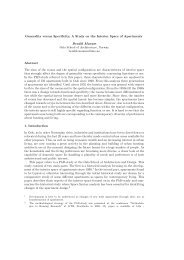
286 <strong>Annegrete</strong> <strong>Hohmann</strong>-Vogr<strong>in</strong> Figure 122: General map of Tikal by Carr and Hazard (Carr and Hazard 1961).
<strong>Space</strong> <strong>Syntax</strong> <strong>in</strong> <strong>Maya</strong> <strong>Architecture</strong> 287 important for Hillier’s analysis. Can the concept of “space syntax” then be productive at all How can we start an analysis of these towns that aims at detect<strong>in</strong>g the constituents of spatial order, and at draw<strong>in</strong>g further conclusions regard<strong>in</strong>g functional possibilities or aspects of the social milieu Address<strong>in</strong>g the question of functional possibilities, we may simply ask for the <strong>in</strong>tegration values of the different areas def<strong>in</strong><strong>in</strong>g convex maps with an appropriate tessellation to take <strong>in</strong>to account the vary<strong>in</strong>g dimensions of the spatial elements (Hillier, 1996, p. 96). It would also be necessary to consider their different levels. In order to do this, the procedure would need to be extended by add<strong>in</strong>g a value for gett<strong>in</strong>g from one level to the next. As stated above, <strong>in</strong> analyz<strong>in</strong>g the spatial structure of Copan, the author has already made an attempt to def<strong>in</strong>e accessibility and centrality of the different areas <strong>in</strong> the Ma<strong>in</strong> Group <strong>in</strong> Copan <strong>in</strong> a much simpler way (<strong>Hohmann</strong> and Vogr<strong>in</strong> 1982, p. 91). A more detailed and reliable distribution of <strong>in</strong>tegration values for the different areas could give us better <strong>in</strong>dications for the more public or more private character of specific areas, and whether they were designed to be accessible to everybody or to a m<strong>in</strong>ority. These are the ma<strong>in</strong> constituents for determ<strong>in</strong><strong>in</strong>g function <strong>in</strong> general. As expla<strong>in</strong>ed above, <strong>Maya</strong> towns do not show l<strong>in</strong>ear spatial elements, so important for the orientation <strong>in</strong> “normal towns”. The horizontal axis guid<strong>in</strong>g the flow of people <strong>in</strong> “normal towns” was not relevant at all <strong>in</strong> this context It can be recognized without any detailed analysis that orientation and result<strong>in</strong>g physical movement <strong>in</strong> <strong>Maya</strong> towns are obviously guided by the altitude of monumental structures that could be seen from afar. Intelligibility of the overall pattern was also easy to assume, as these structures or groups of monumental structures usually showed different faces on each side and, <strong>in</strong>terest<strong>in</strong>gly enough, despite the absence of symmetry <strong>in</strong> spatial arrangements, these faces or facades are often symmetrical, emphasiz<strong>in</strong>g verticality. In most cases, the height of the ma<strong>in</strong> groups is the result of frequent overbuild<strong>in</strong>g. Overbuild<strong>in</strong>g also needs more space at the base of the structures and may have required the extension of the plazas at the front to reta<strong>in</strong> an adequate field of vision. The causeways may have had a similar function. The growth of a site may therefore have started out as a random process, or from the topological configuration of small housemound groups, but then had to follow regularities lead<strong>in</strong>g to a more geometric order. These observations are quite general, made without a comprehensive analysis or further proof. But they already allow us to state that the obvious randomness of structures as shown here <strong>in</strong> the ground plan of Tikal (figure 122) and Copan (figure 124) will be relativized, add<strong>in</strong>g the 3rd dimension. Even the “paradox of centrality” (“maximiz<strong>in</strong>g <strong>in</strong>ternal <strong>in</strong>tegration also maximises external segregation”), and consequently the “paradox of visibility” (“arrang<strong>in</strong>g a series of urban areas <strong>in</strong> a l<strong>in</strong>e maximises the mean trip length and maximises also visibility”) are presumably not valid <strong>in</strong> configurations where different heights are the ma<strong>in</strong> constituents. Integrat<strong>in</strong>g the 3rd dimension will therefore be essential <strong>in</strong> the analysis <strong>in</strong> order to get relevant results <strong>in</strong> this context. A spatial model of visibility will be necessary for expand<strong>in</strong>g space syntax to <strong>in</strong>clude these spatial cultures. Start<strong>in</strong>g from the model of “all l<strong>in</strong>e visibility” (Hillier, 1996, p. 345), we must state that the l<strong>in</strong>es are not l<strong>in</strong>es <strong>in</strong> reality. A l<strong>in</strong>e shown <strong>in</strong> the plan is the <strong>in</strong>tersection of a vertical plane with the horizontal plane of representation, <strong>in</strong> most cases the ground plan, the vertical plane conta<strong>in</strong><strong>in</strong>g all possible l<strong>in</strong>es of sight there<strong>in</strong>. In the 3-dimensional model, that vertical plane <strong>in</strong>tersects the elevation of structures, and as these structures <strong>in</strong> “normal cities” are mostly vertical, the <strong>in</strong>tersection l<strong>in</strong>e of the two planes is vertical, shown as a po<strong>in</strong>t <strong>in</strong> the ground plan. This is not the case <strong>in</strong> the context of <strong>Maya</strong> architecture. The