The Mexican American War PDF - Denver Public Schools
The Mexican American War PDF - Denver Public Schools
The Mexican American War PDF - Denver Public Schools

Create successful ePaper yourself
Turn your PDF publications into a flip-book with our unique Google optimized e-Paper software.
<strong>The</strong> <strong>Mexican</strong>-<strong>American</strong> <strong>War</strong><br />
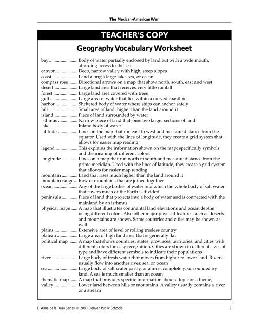
TEACHER’S COPY<br />
Geography Vocabulary Worksheet<br />
bay ......................... Body of water partially enclosed by land but with a wide mouth,<br />
affording access to the sea<br />
canyon .................. Deep, narrow valley with high, steep slopes<br />
coast ...................... Land along a large lake, sea, or ocean<br />
compass rose........ Directional arrows on a map that show north, south, east and west<br />
desert .................... Large land area that receives very little rainfall<br />
forest ..................... Large land area covered with trees<br />
gulf ........................ Large area of water that lies within a curved coastline<br />
harbor ................... Sheltered body of water where ships can anchor safely<br />
hill ......................... Small area of land, higher than the land around it<br />
island .................... Piece of land surrounded by water<br />
isthmus ................. Narrow piece of land that joins two larger sections of land<br />
lake ........................ Inland body of water<br />
latitude ................. Lines on the map that run east to west and measure distance from the<br />
equator. Used with the lines of longitude, they create a grid system that<br />
allows for easier map reading.<br />
legend ................... This explains the information shown on the map; specifically symbols<br />
and the meaning of different colors.<br />
longitude .............. Lines on a map that run north to south and measure distance from the<br />
prime meridian. Used with the lines of latitude, they create a grid system<br />
that allows for easier map reading<br />
mountain .............. Land that rises much higher than the land around it<br />
mountain range ... Row of mountains that are joined together<br />
ocean ..................... Any of the large bodies of water into which the whole body of salt water<br />
that covers much of the Earth is divided<br />
peninsula .............. Piece of land that projects into a body of water and is connected with the<br />
mainland by an isthmus<br />
physical maps ...... A map that illustrates continental land elevations and ocean depths<br />
using different colors. Also other major physical features such as deserts<br />
and mountains are shown. Some countries and cities may be shown as<br />
well.<br />
plains .................... Extensive area of level or rolling treeless country<br />
plateau .................. Large area of high land area that is generally flat<br />
political map ........ A map that shows countries, states, provinces, territories, and cities with<br />
different colors for easy recognition. Cities are shown in different sizes of<br />
type and have different symbols to indicate their populations.<br />
river....................... Large body of fresh water that moves from higher to lower land. Rivers<br />
usually flow into another river, sea, or ocean<br />
sea.......................... Large body of salt water partly, or almost completely, surrounded by<br />
land. A sea is much smaller than an ocean<br />
thematic map ....... A map that provides specific information about a topic or a theme,<br />
valley .................... Lower land between hills or mountains. A valley usually contains a river<br />
or a stream<br />
El Alma de la Raza Series. © 2000 <strong>Denver</strong> <strong>Public</strong> <strong>Schools</strong> 9