Field Farm - Planning Applications - Broxtowe Borough Council
Field Farm - Planning Applications - Broxtowe Borough Council
Field Farm - Planning Applications - Broxtowe Borough Council
- No tags were found...

Create successful ePaper yourself
Turn your PDF publications into a flip-book with our unique Google optimized e-Paper software.
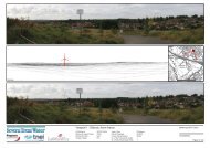
<strong>Field</strong> <strong>Farm</strong> appendix 3.0<br />
-3-<br />
-4-<br />
Christopher Lindley Esq<br />
Our Ref: LR/EDP293/DL/js<br />
25 October 2012<br />
Christopher Lindley Esq<br />
Our Ref: LR/EDP293/DL/js<br />
25 October 2012<br />
Prominent Area Designation<br />
A ‘Prominent Area’ designation protects the character and appearance of land to the immediate<br />
east of the site and slightly further east at Bramcote Hills. Policy E13 of the BLP remains in place<br />
and is saved within the DACS. Therefore, the policy context in relation to this matter remains as<br />
in 2011.<br />
Tree Preservation Orders<br />
At the time of writing of the 2011 assessment, no Tree Preservation Orders (TPO’s) were in place<br />
on the <strong>Field</strong> <strong>Farm</strong> site.<br />
However, following pre-application discussions with <strong>Broxtowe</strong> <strong>Borough</strong> <strong>Council</strong>, a TPO was<br />
imposed protecting two mature oak trees at the western end of the site and the immature<br />
woodland planting belt in the eastern half of the site.<br />
As such, Policy E24 of the BLP applies:<br />
‘Development that would adversely affect important trees and hedgerows will<br />
not be permitted’.<br />
Conclusions in respect of effects on ‘important trees’ are provided in the concluding section of<br />
this letter.<br />
Green Space Strategy<br />
At the time of writing of the 2011 LVIA, <strong>Broxtowe</strong> <strong>Borough</strong> <strong>Council</strong>’s (BBC) Green Spaces<br />
Strategy was in draft form, having been published for consultation. It appears from the BBC<br />
website that this has now been adopted, though no information is given as to the date of this.<br />
The lifespan of the strategy is 2009 – 2019 and its key aims remain as defined within the draft<br />
document.<br />
BLP Policy RC6 continues to set out the requirements for open space provision within new<br />
developments and is proposed to be saved within the DACS.<br />
Chapter 8 of the NPPF, ‘Promoting Healthy Communities’, includes recommendations for the<br />
provision of ‘high quality open spaces’. It requires that public rights of way and access are<br />
protected and enhanced.<br />
The NPPF also defines a new landscape designation (at paragraph 76) titled ’Local Green Space’.<br />
This designation is to be used cautiously (paragraph 77 states that it ‘will not be appropriate for<br />
most green areas or open space’) and should only be designated when a plan (local or<br />
neighbourhood) is prepared or reviewed.<br />
There has been no suggestion within the JACS or elsewhere that the <strong>Field</strong> <strong>Farm</strong> site, or any part<br />
of it, should be designated as Local Green Space (LGS). Furthermore, the site would not meet<br />
the requirements of the policy test set out at paragraph 77 as it is an extensive tract of land and<br />
is not ‘demonstrably special’. LGS issues are therefore given no further consideration.<br />
Green Infrastructure<br />
A regional Green Infrastructure strategy has been in place for some time within the ‘6c’s Sub<br />
Region’ – comprising Derby, Leicester, Nottingham cities and Derbyshire, Leicestershire and<br />
Nottinghamshire counties. Details of this strategy are set out within the 2011 LVIA and remain<br />
pertinent.<br />
The DACS now provides further Green Infrastructure policy at Policy 16. The relevant section of<br />
the JACS is attached as Appendix 1 to this letter. In essence, this requires:<br />
• a strategic approach to the protection and delivery of Green Infrastructure;<br />
• weighing of the potential harm caused by any proposed development against the need<br />
for and benefit of the development;<br />
• proposed development must enhance the GI network through either onsite or offsite<br />
provision and/or contributions; and<br />
• Landscape character is protected, conserved or enhanced as appropriate.<br />
Landscape Character and Visual Amenity Update<br />
EDP undertook site based assessments of landscape character and visual amenity in April 2010.<br />
In respect of landscape character, the 2011 LVIA concluded:<br />
• The National Landscape Character description of Area 38 ‘Nottinghamshire, Derbyshire<br />
and Yorkshire Coalfield’ is generally appropriate to the site's local context but it is a very<br />
generalised assessment;<br />
• The Nottinghamshire Countryside Appraisal, 1997, identifies the site within the<br />
‘Coalfield <strong>Farm</strong>lands' landscape type. The key characteristics of this area are deemed<br />
generally accurate for the site’s local context though do not contain any specific detail<br />
relating to the site itself;<br />
• The site falls within the NC02 – Babbington Rolling <strong>Farm</strong>lands ‘Policy Zone’ and again<br />
many of the key characteristics of this zone are applicable to the site, though no specific<br />
reference to the site is made;<br />
• The site lies on gently sloping ground, gradually rising from west to east with a more<br />
notable slope at the eastern end, closest to Stapleford Hill;<br />
• The site is located to the north of the A6007 Ilkeston Road and to the northeast of the<br />
main part of the existing settlement of Stapleford. Existing development borders the<br />
-/Cont’d…<br />
-/Cont’d…<br />
<strong>Field</strong> <strong>Farm</strong><br />
Addendum to <strong>Planning</strong> Supporting Statement<br />
C9006/NDA/CSL/November 2012<br />
Copyright DPDS Consulting