Table Current CTs - Renmark Paringa Council
Table Current CTs - Renmark Paringa Council
Table Current CTs - Renmark Paringa Council

Create successful ePaper yourself
Turn your PDF publications into a flip-book with our unique Google optimized e-Paper software.
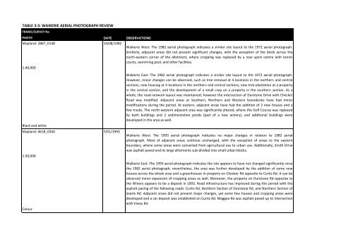
TABLE 3‐3: WAIKERIE AERIAL PHOTOGRAPH REVIEW<br />
FRAME/SURVEY No<br />
PHOTO<br />
Mapland: 2887_0148<br />
1:40,000<br />
Black and white<br />
Mapland: 4618_0344<br />
1:20,000<br />
Colour<br />
DATE<br />
19/08/1982<br />
7/01/1993<br />
OBSERVATIONS<br />
Waikerie West: The 1982 aerial photograph indicates a similar site layout to the 1972 aerial photograph.<br />
Similarly, adjacent areas did not present significant changes, with the exception of the block across the<br />
north‐eastern corner of the allotment, where cropping was replaced by a new sport centre with tennis<br />
courts, swimming pool, and other facilities.<br />
Waikerie East: The 1982 aerial photograph indicates a similar site layout to the 1972 aerial photograph.<br />
However, minor changes can be observed, such as tree removal at 4 locations in the northern and central<br />
sections, new housing at 4 locations in the northern and central sections, new tree plantation at a property<br />
in the central section, and the development of a small crop on a property in the southern section. As a<br />
whole, the road network layout was maintained; however the intersection of Dunstone Drive with Checker<br />
Road was modified. Adjacent areas at Southern, Northern and Western boundaries have had minor<br />
modifications during the period. At eastern, adjacent areas have had the addition of 2 new houses and a<br />
few tracks. The north‐western adjacent area was significantly altered, where the Golf Course was replaced<br />
by both buildings and 2 sedimentation ponds (part of a new winery), and additional buildings were<br />
developed in the area as well.<br />
Waikerie West: The 1993 aerial photograph indicates no major changes in relation to 1982 aerial<br />
photograph. Most of adjacent areas continue unchanged, with the exception of areas to the eastern<br />
boundary, where some areas were converted from agricultural use to urban use. Additionally, Smith Drive<br />
was asphalt paved and its large allotments sub‐divided into small urban blocks.<br />
Waikerie East: The 1993 aerial photograph indicates the site appears to have not changed significantly since<br />
the 1982 aerial photograph; nevertheless, the area was further developed by the addition of some new<br />
houses across the whole area and a greenhouses in property on Checker Rd opposite to Curtis Rd. It can be<br />
observed minor expansion of cropping areas as well. Moreover, the property on Dunstone Rd opposite to<br />
the Winery appears to be a deposit in 1993. Road infrastructure has improved during this period with the<br />
asphalt paving of the following roads: Curtis Rd, Northern Section of Dunstone Rd, and Northern Section of<br />
Searle Rd. Adjacent areas did not present major changes, yet some few houses and cropping areas were<br />
developed and a car deposit was established on Curtis Rd. Maggea Rd was asphalt paved up to intersection<br />
with Vasey Rd.