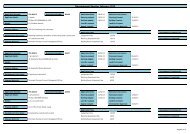
Table Current CTs - Renmark Paringa Council
Table Current CTs - Renmark Paringa Council
Table Current CTs - Renmark Paringa Council

You also want an ePaper? Increase the reach of your titles
YUMPU automatically turns print PDFs into web optimized ePapers that Google loves.
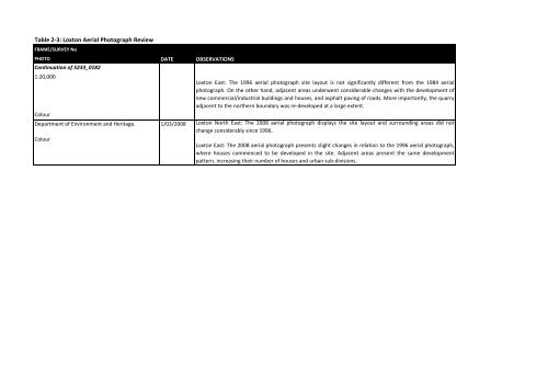
<strong>Table</strong> 2‐3: Loxton Aerial Photograph Review<br />
FRAME/SURVEY No<br />
PHOTO<br />
Continuation of 5233_0182<br />
1:20,000<br />
Colour<br />
Department of Environment and Heritage.<br />
Colour<br />
DATE<br />
1/03/2008<br />
OBSERVATIONS<br />
Loxton East: The 1996 aerial photograph site layout is not significantly different from the 1984 aerial<br />
photograph. On the other hand, adjacent areas underwent considerable changes with the development of<br />
new commercial/industrial buildings and houses, and asphalt paving of roads. More importantly, the quarry<br />
adjacent to the northern boundary was re‐developed at a large extent.<br />
Loxton North East: The 2008 aerial photograph displays the site layout and surrounding areas did not<br />
change considerably since 1996.<br />
Loxton East: The 2008 aerial photograph presents slight changes in relation to the 1996 aerial photograph,<br />
where houses commenced to be developed in the site. Adjacent areas present the same development<br />
pattern, increasing their number of houses and urban sub‐divisions.