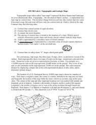
San Juan Islands, WA - Puget Sound Lidar Consortium
San Juan Islands, WA - Puget Sound Lidar Consortium
San Juan Islands, WA - Puget Sound Lidar Consortium

Create successful ePaper yourself
Turn your PDF publications into a flip-book with our unique Google optimized e-Paper software.
4.2 Absolute Accuracy<br />
The vertical accuracy of the LiDAR data is described as the mean and standard deviation<br />
(sigma ~ σ) of divergence of LiDAR point coordinates from RTK ground survey point<br />
coordinates. To provide a sense of the model predictive power of the dataset, the root mean<br />
square error (RMSE) for vertical accuracy is also provided. These statistics assume the error<br />
distributions for x, y, and z are normally distributed, thus we also consider the skew and<br />
kurtosis of distributions when evaluating error statistics.<br />
Statements of statistical accuracy apply to fixed terrestrial surfaces only and may not be<br />
applied to areas of dense vegetation or steep terrain. To calibrate laser accuracy for the<br />
LiDAR dataset, 2644 RTK ground survey points were collected on fixed, hard-packed road<br />
surfaces within the survey area.<br />
LiDAR Data Acquisition and Processing: <strong>San</strong> <strong>Juan</strong> <strong>Islands</strong>, <strong>WA</strong><br />
Prepared by Watershed Sciences, Inc.<br />
-11-