San Juan Islands, WA - Puget Sound Lidar Consortium
San Juan Islands, WA - Puget Sound Lidar Consortium
San Juan Islands, WA - Puget Sound Lidar Consortium

You also want an ePaper? Increase the reach of your titles
YUMPU automatically turns print PDFs into web optimized ePapers that Google loves.
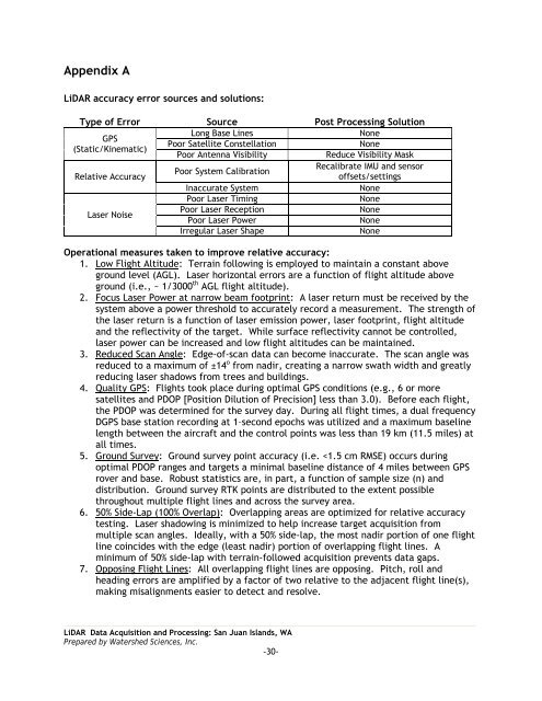
Appendix A<br />
LiDAR accuracy error sources and solutions:<br />
Type of Error Source Post Processing Solution<br />
Long Base Lines<br />
None<br />
GPS<br />
Poor Satellite Constellation<br />
None<br />
(Static/Kinematic)<br />
Poor Antenna Visibility<br />
Reduce Visibility Mask<br />
Recalibrate IMU and sensor<br />
Poor System Calibration<br />
Relative Accuracy<br />
offsets/settings<br />
Inaccurate System<br />
None<br />
Poor Laser Timing<br />
None<br />
Laser Noise<br />
Poor Laser Reception<br />
None<br />
Poor Laser Power<br />
None<br />
Irregular Laser Shape<br />
None<br />
Operational measures taken to improve relative accuracy:<br />
1. Low Flight Altitude: Terrain following is employed to maintain a constant above<br />
ground level (AGL). Laser horizontal errors are a function of flight altitude above<br />
ground (i.e., ~ 1/3000 th AGL flight altitude).<br />
2. Focus Laser Power at narrow beam footprint: A laser return must be received by the<br />
system above a power threshold to accurately record a measurement. The strength of<br />
the laser return is a function of laser emission power, laser footprint, flight altitude<br />
and the reflectivity of the target. While surface reflectivity cannot be controlled,<br />
laser power can be increased and low flight altitudes can be maintained.<br />
3. Reduced Scan Angle: Edge-of-scan data can become inaccurate. The scan angle was<br />
reduced to a maximum of ±14 o from nadir, creating a narrow swath width and greatly<br />
reducing laser shadows from trees and buildings.<br />
4. Quality GPS: Flights took place during optimal GPS conditions (e.g., 6 or more<br />
satellites and PDOP [Position Dilution of Precision] less than 3.0). Before each flight,<br />
the PDOP was determined for the survey day. During all flight times, a dual frequency<br />
DGPS base station recording at 1–second epochs was utilized and a maximum baseline<br />
length between the aircraft and the control points was less than 19 km (11.5 miles) at<br />
all times.<br />
5. Ground Survey: Ground survey point accuracy (i.e.