San Juan Islands, WA - Puget Sound Lidar Consortium
San Juan Islands, WA - Puget Sound Lidar Consortium
San Juan Islands, WA - Puget Sound Lidar Consortium

You also want an ePaper? Increase the reach of your titles
YUMPU automatically turns print PDFs into web optimized ePapers that Google loves.
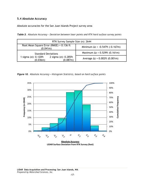
5.4 Absolute Accuracy<br />
Absolute accuracies for the <strong>San</strong> <strong>Juan</strong> <strong>Islands</strong> Project survey area<br />
Table 3. Absolute Accuracy – Deviation between laser points and RTK hard surface survey points<br />
Root Mean Square Error (RMSE) = 0.136 ft<br />
(0.041m)<br />
1 sigma (σ): 0.120ft<br />
(0.036m)<br />
Standard Deviations<br />
RTK Survey Sample Size (n): 2644<br />
2 sigma (σ): 0.285ft<br />
(0.087m)<br />
Minimum ∆z = -0.547ft (-0.167m)<br />
Maximum ∆z = 0.529ft (0.161m)<br />
Average ∆z = 0.002ft (0.001m)<br />
Figure 10. Absolute Accuracy - Histogram Statistics, based on hard surface points<br />
35%<br />
100%<br />
30%<br />
90%<br />
80%<br />
Frequency (n=2644)<br />
25%<br />
20%<br />
15%<br />
10%<br />
70%<br />
60%<br />
50%<br />
40%<br />
30%<br />
Cumulative Frequency<br />
5%<br />
20%<br />
10%<br />
0%<br />
0%<br />
Absolute Accuracy<br />
LiDAR Surface Deviation from RTK Survey (feet)<br />
LiDAR Data Acquisition and Processing: <strong>San</strong> <strong>Juan</strong> <strong>Islands</strong>, <strong>WA</strong><br />
Prepared by Watershed Sciences, Inc.<br />
-17-