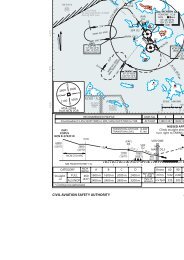
STRAITS OF SINGAPORE VISUAL APPROACH CHART ... - openNav
STRAITS OF SINGAPORE VISUAL APPROACH CHART ... - openNav
STRAITS OF SINGAPORE VISUAL APPROACH CHART ... - openNav

You also want an ePaper? Increase the reach of your titles
YUMPU automatically turns print PDFs into web optimized ePapers that Google loves.
!<br />
!<br />
<br />
<br />
<br />
<br />
<br />
<br />
<br />
<br />
<br />
<br />
<br />
<br />
<br />
<br />
<br />
<br />
<br />
<br />
<br />
<br />
<br />
<br />
<br />
<br />
<br />
<br />
<br />
<br />
<br />
<br />
<br />
<br />
<br />
<br />
<br />
<br />
<br />
<br />
<br />
<br />
<br />
<br />
<br />
<br />
<br />
<br />
<br />
<br />
<br />
<br />
<br />
<br />
<br />
<br />
<br />
<br />
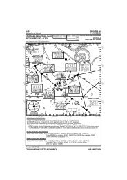
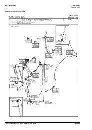
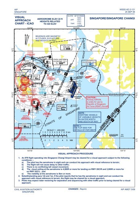
AIP<br />
<strong>SINGAPORE</strong><br />
WSSS AD 2-121<br />
25 SEP 08<br />
<strong>VISUAL</strong><br />
<strong>APPROACH</strong><br />
<strong>CHART</strong> - ICAO<br />
AERODROME ELEV 22 ft<br />
HEIGHTS RELATED<br />
TO AD ELEV<br />
D-ATIS AP ID WSSS<br />
128.6<br />
APP 120.3<br />
119.3<br />
TWR 118.6<br />
118.25<br />
<strong>SINGAPORE</strong>/<strong>SINGAPORE</strong> CHANGI<br />
103°50' 104°00'E 104°10'<br />
01°<br />
30'<br />
276<br />
782<br />
942<br />
!<br />
!<br />
!<br />
!<br />
538<br />
(516)<br />
!<br />
!<br />
!<br />
!<br />
620<br />
!<br />
(999) SEMBAWANG<br />
NDB 325<br />
AG<br />
01° (999)<br />
20'<br />
N<br />
01°<br />
10'<br />
(920)<br />
!<br />
!<br />
TRANSIT<br />
CHANNEL<br />
2 000ft ALT<br />
GND<br />
!<br />
WSD33<br />
500ft ALT<br />
GND<br />
!<br />
WSD35<br />
900ft ALT<br />
GND<br />
WSD1<br />
500ft ALT<br />
GND<br />
VAR 31'E (2005)<br />
!<br />
3 000 AMSL<br />
! ! ! ! ! ! !<br />
SEMBAWANG<br />
!<br />
<br />
<br />
<br />
<br />
<br />
<br />
<br />
<br />
<br />
<br />
<br />
<br />
WSP24<br />
800ft ALT<br />
GND/WATER<br />
WSD4<br />
FL 160<br />
GND/WATER<br />
!<br />
SEMBAWANG ATZ<br />
637<br />
(615)<br />
(598)<br />
SINJON<br />
DVOR/DME 113.5<br />
SJ<br />
250<br />
607<br />
600<br />
(578)<br />
D<br />
!<br />
BEARINGS ARE MAGNETIC<br />
ALTITUDES, ELEVATIONS<br />
AND HEIGHTS IN FEET<br />
CTR A (398)<br />
!<br />
310<br />
SELETAR CTR C<br />
3 000 AMSL<br />
SELETAR<br />
<br />
<br />
<br />
<br />
<br />
<br />
<br />
<br />
<br />
<br />
<br />
<br />
761<br />
920<br />
420<br />
407<br />
(385)<br />
259<br />
217<br />
CTR B<br />
300<br />
(278)<br />
232<br />
330<br />
(308)<br />
345<br />
361<br />
230<br />
! ! ! ! ! ! ! ! ! ! ! ! ! ! ! ! ! ! ! ! ! ! ! ! ! ! ! ! ! ! ! ! ! ! ! ! ! ! ! ! ! ! ! ! ! ! ! ! ! ! ! ! ! ! ! ! ! ! ! ! ! ! ! ! ! ! ! ! !<br />
197<br />
PAYA LEBAR CTR D 3 000 AMSL<br />
<br />
<br />
<br />
<br />
<br />
<br />
<br />
<br />
<br />
<br />
<br />
<br />
263<br />
(210)<br />
(241)<br />
SELETAR<br />
(228) NDB 220<br />
WSP36<br />
POSSIBLE<br />
SEL<br />
1 000ft ALT<br />
VESSEL<br />
(260)<br />
WSD34<br />
GND<br />
IBN<br />
500ft ALT<br />
246<br />
FLG G 'CH'<br />
_<br />
GND<br />
PAYA<br />
(224)<br />
LEBAR<br />
(142)<br />
116<br />
ABN<br />
(237)<br />
PAPI 3<br />
(288)<br />
(94)<br />
ALTN FLG_<br />
W & G<br />
LIGHT ACFT<br />
LIGHT ACFT<br />
(257)<br />
TRAINING<br />
TRAINING AREA B<br />
AREA A 10 000ft ALT<br />
(175)<br />
3 500ft ALT 4 000ft ALT (208)<br />
GND<br />
282<br />
FIR KUALA LUMPUR<br />
PAPI 3<br />
(260)<br />
FIR <strong>SINGAPORE</strong><br />
WSP3<br />
(195)<br />
<strong>SINGAPORE</strong><br />
<br />
<br />
171<br />
<br />
<br />
<br />
750ft ALT<br />
<br />
CHANGI CAUTION :<br />
<br />
<br />
<br />
<br />
<br />
<br />
<br />
<br />
GND<br />
<br />
Runway 02R/20L<br />
(323)<br />
(149)<br />
is solely for use by<br />
(739)<br />
324<br />
Republic of Singapore<br />
POSSIBLE<br />
(585)<br />
584<br />
BEDOK<br />
(562)<br />
(302)<br />
VESSEL<br />
(339) NDB 232<br />
Air Force (RSAF) Aircraft<br />
793<br />
BED<br />
(771)<br />
535 (898)<br />
833<br />
(513)<br />
(811) WSR38<br />
NOTE :<br />
10 000ft ALT<br />
MARITIME VESSELS<br />
GND<br />
<strong>OF</strong> VARIABLE HEIGHTS<br />
IN WATER NORTH<br />
AND SOUTH <strong>OF</strong> RWY<br />
CIVIL AVIATION AUTHORITY<br />
<strong>SINGAPORE</strong><br />
KONG KONG<br />
NDB 286<br />
KK<br />
PAPA UNIFORM<br />
DVOR/DME 115.1<br />
PU<br />
282<br />
164<br />
279<br />
<strong>STRAITS</strong> <strong>OF</strong> <strong>SINGAPORE</strong><br />
SCALE 1 : 400,000<br />
1 0 1 2 3 4 5 6 7 8 9 km<br />
1 0 1 2 3 4 5 NM<br />
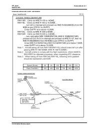
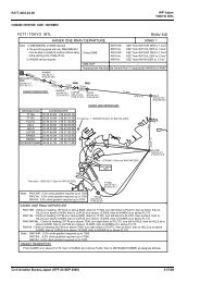
NOTE 2 :<br />
SEE FLIP SIDE FOR<br />
DETAILS <strong>OF</strong> PAPI MEHT<br />
CHANGI CTR C 3 000 AMSL<br />
TANJUNG PINANG NORTH ZONE CTR B 3 000 AMSL/<br />
BATAM ATZ C 1 500 AMSL<br />
103°50' 104°00'E 104°10'<br />
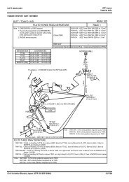
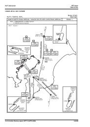
<strong>VISUAL</strong> <strong>APPROACH</strong> PROCEDURE<br />
1. An IFR flight operating into Singapore Changi Airport may be cleared for a visual approach subject to the following<br />
conditions :-<br />
a) The pilot has the aerodrome in sight and can conduct his approach with visual reference to terrain;<br />
b) The flight will not cause delay to other traffic;<br />
c) There is no conflicting tall vessel movement;<br />
d) The cloud ceiling at the aerodrome is 4,000ft or more for landing on RWY 20C/R and 3,000ft or more for<br />
on RWY 02C/L ; and<br />
e) The visibility at the aerodrome is 5km or more.<br />
2. Notwithstanding para 1d) and 1e), if the pilot reports that he has the aerodrome in sight and can conduct his<br />
approach with visual reference to terrain, the flight may be cleared for a visual approach.<br />
3. Pilots may expect radar vectoring for separation and sequencing with other traffic prior to being cleared for a visual<br />
approach.<br />
SUNGEI JOHOR<br />
CHANGES : Reprint.<br />
SUNGEI<br />
TEKONG<br />
DVOR/DME 116.5<br />
VTK<br />
LEBAM<br />
ELEVATIONS 942<br />
HEIGHTS (920)<br />
! ! ! ! ! !<br />
AIP AMDT 5/08<br />
01°<br />
30'<br />
01°<br />
20'<br />
N<br />
01°<br />
10'<br />
! ! ! ! ! ! ! ! ! ! ! ! ! ! ! ! ! ! ! ! ! ! ! ! ! ! ! ! ! ! ! !
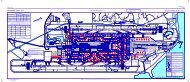
PAPI 3° (MEHT)*<br />
Pilot's eye height over the<br />
RUNWAY<br />
threshold when the following<br />
PAPI lights come into view.<br />
02L 20R 02C 20C<br />
2 White lights and 2 Red lights<br />
20.6m 20.0m 20.4m 20.4m<br />
3 White lights and 1 Red light<br />
23.1m 22.6m 23.1m 23.1m<br />
4 White lights<br />
25.6m 25.0m 25.5m 25.5m<br />
*MEHT : Minimum Eye Height Over the Threshold<br />
Note : Aircraft with eye-to-wheel height greater than 8 metres are advised to fly with<br />
2 white lights and 2 red lights visible so as to achieve sufficient wheel<br />
clearance.