RJTT / TOKYO INTL RNAV STAR RWY16L/16R JONAN ... - openNav
RJTT / TOKYO INTL RNAV STAR RWY16L/16R JONAN ... - openNav
RJTT / TOKYO INTL RNAV STAR RWY16L/16R JONAN ... - openNav
- No tags were found...

You also want an ePaper? Increase the reach of your titles
YUMPU automatically turns print PDFs into web optimized ePapers that Google loves.
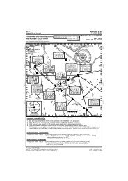
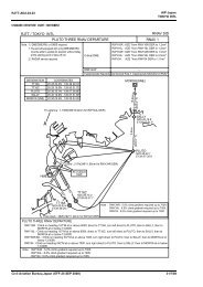
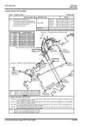
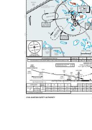
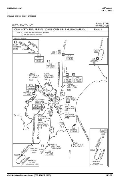
<strong>RJTT</strong>-AD2-24.43AIP Japan<strong>TOKYO</strong> <strong>INTL</strong>STANDARD ARRIVAL CHART-INSTRUMENT<strong>RJTT</strong> / <strong>TOKYO</strong> <strong>INTL</strong>Note 1 ) DME/DME/IRU or GNSS required.2 ) RADAR service required.<strong>RNAV</strong> <strong>STAR</strong><strong>RWY16L</strong>/<strong>16R</strong><strong>JONAN</strong> NORTH <strong>RNAV</strong> ARRIVAL / <strong>JONAN</strong> SOUTH NR1 & NR2 <strong>RNAV</strong> ARRIVAL <strong>RNAV</strong> 1VAR 7° W(2007)DAIBAVOR/DME(DYE)WESTNDYE 5.0DMER-120060°<strong>JONAN</strong>DYEVOR/DME111.0MHzHMEVOR/DME112.2MHz240°OJC 23.0DMER-240<strong>JONAN</strong> SOUTH NR1 <strong>RNAV</strong> ARRIVALSYEVOR/DME117.0MHzKEIYON35-29-10.6E140-02-07.4KZEVOR/DME114.5MHzONJUKUVORTAC(OJC)MHA5000IAS 230ktor less above 14000OJC 31.0DMEDYE 9.0DME120°300°MHA2000<strong>JONAN</strong>N35-34-16.4E139-54-42.12000VOR AVOR CV17Y211304°(297.3° T)SNEVOR/DME114.0MHzAMUSEN35-32-53.0E139-58-00.325003.0nm 5.0nm010°(317.8° T)010°TT161N35-23-06.1E140-01-39.54000TT162N35-17-20.9E140-01-12.7FL140010°325°(003.6° T)6.1nm(003.6° T)5.8nm<strong>JONAN</strong> NORTH <strong>RNAV</strong> ARRIVAL277°(270.2° T)4.8nm5.3nm(003.6° T)20.0nmPQEVOR/DME112.5MHzAMIN36-01-16.3E140-12-19.8(331.2° T)338°4.6nm206°(331.3° T)338°(331.4° T)21.4nmWESTNN34-57-19.5E139-59-39.9V22, Y10189°(198.9° T)8.6nm338°TLEVOR/DME116.0MHz(181.8° T)24.0nmTYEVOR/DME112.7MHzWAKBAN35-37-17.5E140-11-25.48000ANEGAN35-29-09.9E140-08-01.34000TT163N35-24-32.4E140-05-14.34000TT164N35-20-30.0E140-07-56.4FL140V18NREVOR/DME117.9MHzOJCVORTAC115.7MHz<strong>JONAN</strong> SOUTH NR2 <strong>RNAV</strong> ARRIVALOTAKIN35-01-40.8E140-20-27.3OTAKIFL1408000AMIVOR/DME(TLE)016°196°R-196OJC 9.4DME196°TLE R-016016°ONJUKUVORTAC(OJC)MHA5000IAS 230ktor less above 14000OJC 17.4DMECivil Aviation Bureau,Japan (EFF:10APR 2008) 14/2/08
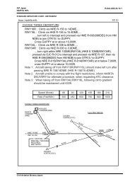
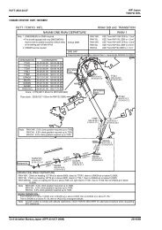
AIP Japan<strong>TOKYO</strong> <strong>INTL</strong><strong>RJTT</strong>-AD2-24.43-1<strong>RJTT</strong> / <strong>TOKYO</strong> <strong>INTL</strong><strong>RNAV</strong> <strong>STAR</strong><strong>RWY16L</strong>/<strong>16R</strong><strong>JONAN</strong> NORTH <strong>RNAV</strong> ARRIVALFrom TLE, to WAKBA at or above 8,000ft, to ANEGA at or above 4,000ft, to KEIYO, to AMUSE at orabove 2.500ft, to <strong>JONAN</strong> at or above 2,000ft.FIXCritical DMEDME GAPInappropriate NavaidsDESIGNATIONAMI (TLE)WAKBAANEGAKEIYOAMUSE<strong>JONAN</strong>COORDINATES360116.3N 1401219.8E353717.5N 1401125.4E352909.9N 1400801.3E352910.6N 1400207.4E353253.0N 1395800.3E353416.4N 1395442.1E––See General Rule 3. Inappropriate NAVAIDs for <strong>RNAV</strong>1Rcmd. PathTerminatorIFTFTFTFTFTFFix ID(WaypointName)TLEWAKBAANEGAKEIYOAMUSE<strong>JONAN</strong>FlyOverDistance(NM)24.08.64.85.03.0MAG Track(TRUETrack)189°(181.8°)206°(198.9°)277°(270.2°)325°(317.8°)304°(297.3°)Turn AltitudeDirection (ft.)+8000+4000+2500+2000Speed Vertical NavigationLimit(kt)Angle Performance<strong>RNAV</strong>1<strong>RNAV</strong>1<strong>RNAV</strong>1<strong>RNAV</strong>1<strong>RNAV</strong>1<strong>RNAV</strong>1<strong>JONAN</strong> SOUTH NR1 <strong>RNAV</strong> ARRIVALFrom WESTN, to TT162 at or below FL140, to TT161 at or above 4,000ft to KEIYO, to AMUSE at or above2,500ft, to <strong>JONAN</strong> at or above 2,000ft.FIXCritical DMEDME GAPInappropriate NavaidsDESIGNATIONWESTNTT162TT161KEIYOAMUSE<strong>JONAN</strong>COORDINATES345719.5N 1395939.9E351720.9N 1400112.7E352306.1N 1400139.5E352910.6N 1400207.4E353253.0N 1395800.3E353416.4N 1395442.1E––See General Rule 3. Inappropriate NAVAIDs for <strong>RNAV</strong>1Rcmd. PathTerminatorIFTFTFTFTFTFFix ID(WaypointName)FlyOverWESTN TT162 TT161 KEIYO AMUSE <strong>JONAN</strong> Distance(NM)20.05.86.15.03.0MAG Track(TRUETrack)010°(003.6°)010°(003.6°)010°(003.6°)325°(317.8°)304°(297.3°)Turn AltitudeDirection (ft.)-FL140+4000+2500+2000Speed Vertical NavigationLimit(kt)Angle Performance<strong>RNAV</strong>1<strong>RNAV</strong>1<strong>RNAV</strong>1<strong>RNAV</strong>1<strong>RNAV</strong>1<strong>RNAV</strong>1<strong>JONAN</strong> SOUTH NR2 <strong>RNAV</strong> ARRIVALFrom OTAKI, to TT164 at or below FL140, to TT163 at or above 4,000ft, to KEIYO, to AMUSE at or above2,500ft, to <strong>JONAN</strong> at or above 2,000ft.FIXCritical DMEDME GAPInappropriate NavaidsDESIGNATIONOTAKITT164TT163KEIYOAMUSE<strong>JONAN</strong>COORDINATES350140.8N 1402027.3E352030.0N 1400756.4E352432.4N 1400514.3E352910.6N 1400207.4E353253.0N 1395800.3E353416.4N 1395442.1E––See General Rule 3. Inappropriate NAVAIDs for <strong>RNAV</strong>1Rcmd. PathTerminatorIFTFTFTFTFTFFix ID(WaypointName)OTAKITT164TT163KEIYOAMUSE<strong>JONAN</strong>FlyOverDistance(NM)21.44.65.35.03.0MAG Track(TRUETrack)338°(331.4°)338°(331.3°)338°(331.2°)325°(317.8°)304°(297.3°)Turn AltitudeDirection (ft.)-FL140+4000+2500+2000Speed Vertical NavigationLimit(kt)Angle Performance<strong>RNAV</strong>1<strong>RNAV</strong>1<strong>RNAV</strong>1<strong>RNAV</strong>1<strong>RNAV</strong>1<strong>RNAV</strong>1Civil Aviation Bureau,Japan (EFF:10 APR 2008) 14/2/08