Langham Park Developments Proposed Residential Development ...
Langham Park Developments Proposed Residential Development ...
Langham Park Developments Proposed Residential Development ...

You also want an ePaper? Increase the reach of your titles
YUMPU automatically turns print PDFs into web optimized ePapers that Google loves.
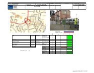
<strong>Proposed</strong> <strong>Development</strong> off Low Wood Road, Nottingham<br />
4 Access Arrangements<br />
Vehicular, pedestrian and cycle access is proposed off Low Wood Road in the position<br />
shown on the OIC access proposal drawing in Appendix A. The position of the access, that<br />
will form a new priority junction, that was agreed in principle with Nottinghamshire County<br />
Council (NCC) at a meeting in early November 2011. As NCC did raise slight concerns<br />
over the distance between Apollo Drive, to the north, and the proposed development<br />
access a speed survey was undertaken adjacent to the proposed access point. The speed<br />
survey showed the following 85 th percentile speeds that resulted in an average 85 th<br />
percentile speed of 40 mph;<br />
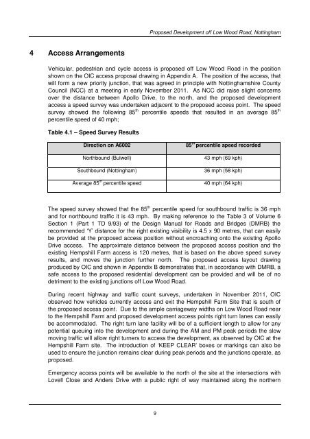
Table 4.1 – Speed Survey Results<br />
Direction on A6002<br />
Northbound (Bulwell)<br />
Southbound (Nottingham)<br />
Average 85 th percentile speed<br />
85 th percentile speed recorded<br />
43 mph (69 kph)<br />
36 mph (58 kph)<br />
40 mph (64 kph)<br />
The speed survey showed that the 85 th percentile speed for southbound traffic is 36 mph<br />
and for northbound traffic it is 43 mph. By making reference to the Table 3 of Volume 6<br />
Section 1 (Part 1 TD 9/93) of the Design Manual for Roads and Bridges (DMRB) the<br />
recommended ‘Y’ distance for the right existing visibility is 4.5 x 90 metres, that can easily<br />
be provided at the proposed access position without encroaching onto the existing Apollo<br />
Drive access. The approximate distance between the proposed access position and the<br />
existing Hempshill Farm access is 120 metres, that is based on the above speed survey<br />
results, and moves the junction further north. The proposed access layout drawing<br />
produced by OIC and shown in Appendix B demonstrates that, in accordance with DMRB, a<br />
safe access to the proposed residential development can be provided and will be of no<br />
detriment to the existing junctions off Low Wood Road.<br />
During recent highway and traffic count surveys, undertaken in November 2011, OIC<br />
observed how vehicles currently access and exit the Hempshill Farm Site that is south of<br />
the proposed access point. Due to the ample carriageway widths on Low Wood Road near<br />
to the Hempshill Farm and proposed development access points right turn lanes can easily<br />
be accommodated. The right turn lane facility will be of a sufficient length to allow for any<br />
potential queuing into the development and during the AM and PM peak periods the slow<br />
moving traffic will allow right turners to access the development, as observed by OIC at the<br />
Hempshill Farm site. The introduction of ‘KEEP CLEAR’ boxes or markings can also be<br />
used to ensure the junction remains clear during peak periods and the junctions operate, as<br />
proposed.<br />
Emergency access points will be available to the north of the site at the intersections with<br />
Lovell Close and Anders Drive with a public right of way maintained along the northern<br />
9