Harden, J.W., K.L. Manies, J. O'Donnell, K. Johnson, S. Frolking, Z ...
Harden, J.W., K.L. Manies, J. O'Donnell, K. Johnson, S. Frolking, Z ...
Harden, J.W., K.L. Manies, J. O'Donnell, K. Johnson, S. Frolking, Z ...

You also want an ePaper? Increase the reach of your titles
YUMPU automatically turns print PDFs into web optimized ePapers that Google loves.
G01012<br />
HARDEN ET AL.: C FATE IN BLACK SPRUCE FOREST SOILS<br />
G01012<br />
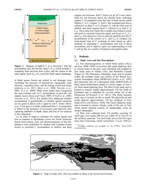
organic-soil horizons. Soil C stocks (in gC/m 2 ) were calculated<br />
for soil horizons above the charred layer, reflecting<br />
organic C accumulation since the time of burn, herein called<br />
shallow C or C s (Figure 1). Soil C that remained post-fire is<br />
referred to as deep C or C d (Figure 1), with the total sum of<br />
shallow and deep organic-layer C referred to as total C or<br />
C tol . These data were input into a simple mass balance model<br />
and used to constrain long-term inputs and losses to C s ,C d ,<br />
and C tol . Our objectives were to robustly quantify post-fire C<br />
accumulation in the context of C s and C d ; to compare our<br />
stock-based rates of C exchange to rates based on other<br />
methods of estimating C accumulation and loss in these<br />
ecosystems; and to improve upon our understanding of soil<br />
C and its fate at a variety of temporal and spatial scales.<br />
Figure 1. Diagram of shallow C (C s ), showing C that has<br />
accumulated since the last fire; deep C (C d ), which includes C<br />
remaining from previous burn cycles; and the carbon in the<br />
total organic layer (C tol ) in a post-fire black spruce landscape.<br />
in black spruce forests are related to soil drainage class<br />
(including the presence of permafrost), topography, burn<br />
intensity, vegetation class, and the timing of previous burns<br />
[<strong>Johnson</strong> et al., 2011; Mack et al., 2008; Turetsky et al.,<br />
2005; Yi et al., 2009]. While some studies have recognized<br />
the near-constant rate of C accumulation in post-fire soil<br />
organic layers [Kane and Vogel, 2009; O’Neill et al., 2006;<br />
Turetsky et al., 2011], few studies have addressed whether<br />
accumulation is generalizable or whether spatial variations<br />
are too great to detect such a signal in soil C stocks. Moreover,<br />
if our goal is to better understand how C accumulation<br />
is linked to the dynamics of succession and regrowth, then<br />
capturing attributes of depth, input, and loss in our analysis<br />
is also important.<br />
[5] In order to improve estimates for carbon uptake and<br />
loss in response to disturbance across the North American<br />
boreal forest biome, four soil chronosequences of fire disturbance<br />
were established in Alaskan and Canadian boreal<br />
forests to constrain C accumulation in shallow and deep<br />
2. Methods<br />
2.1. Study Area and Site Descriptions<br />
[6] Fire chronosequences, in which black spruce (Picea<br />
mariana (Mill.) BSP) ecosystems had stand-replacing fires<br />
at various times in the past, were identified and sampled in<br />
four study areas in Alaska, USA, and Manitoba, Canada<br />
(Figure 2). The Thompson, Manitoba, study area is located<br />
within the northern study area (NSA) of the Boreal Ecosystem<br />
Atmosphere Study (BOREAS) [Sellers et al., 1997]<br />
and represents sites of a subsequent study (FIRES-ExB) of<br />
black spruce/feathermoss stands in various stages of recovery<br />
from stand-replacing fires. The Hess Creek study area is<br />
located in interior Alaska approximately 150 km north of<br />
Fairbanks and is underlain by ice-rich eolian silt of the<br />
Pleistocene [O’Donnell et al., 2011]. The Delta Junction<br />
study area is located on flat to nearly flat glaciofluvial and<br />
eolian deposits approximately 150 km southeast of Fairbanks<br />
[Péwé and Holmes, 1964]. The Taylor Highway study<br />
area is located in interior Alaska, north of the city of Tok,<br />
where parent material consists of metamorphic rocks on<br />
steeper topography.<br />
[7] Data were collected from 316 profiles covering 24<br />
stand ages over nearly 200 yrs (see Table S3 in Text S1 of<br />
the auxiliary material). 1 For each study area at least five ages<br />
since time of last burn, which varied from 100 yrs,<br />
1 Auxiliary materials are available in the HTML. doi:10.1029/<br />
2011JG001826.<br />
Figure 2.<br />
Map of study sites. The area shaded in black is the boreal forest biome.<br />
2of9