Harden, J.W., K.L. Manies, J. O'Donnell, K. Johnson, S. Frolking, Z ...
Harden, J.W., K.L. Manies, J. O'Donnell, K. Johnson, S. Frolking, Z ...
Harden, J.W., K.L. Manies, J. O'Donnell, K. Johnson, S. Frolking, Z ...

Create successful ePaper yourself
Turn your PDF publications into a flip-book with our unique Google optimized e-Paper software.
G01012<br />
HARDEN ET AL.: C FATE IN BLACK SPRUCE FOREST SOILS<br />
G01012<br />
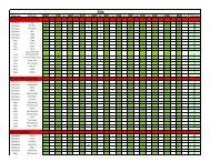
Table 1. Site Characteristics of Four Black Spruce Chronosequences in Alaska and Manitoba a<br />
Site Characteristics Delta Junction, AK Hess Creek, AK Taylor Highway, AK Thompson, MB<br />
Stand ages (yrs) 2, 7, 19, 27, 45†, 50†, 116 4, 14, 17, 40, 98, 148, 198 4, 18, 20, 22, 42, 132 0, 5, 8, 14, 22, 39, 73, 153<br />
Number of soil profiles 77 89 50 100<br />
Latitude (°N) 63.9 65.6 63.4 55.9<br />
Elevation (m) 429 289 867 259<br />
Slope (%) 0–2 3–9 6–9 0–3<br />
Mean summer temperature (°C) ‡ 13.5 13.8 12.3 14.2<br />
Mean winter temperature (°C) ‡ 20.2 24.8 19.7 22.4<br />
Growing season length (days) ‡ 174 163 170 N.D.<br />
Annual precipitation (mm) ‡ 383 310 351 517<br />
Parent material silt over glaciofluvial outwash silty loess silty loess over bedrock lacustrine clay and silt<br />
Soil drainage class somewhat poorly somewhat poorly well to moderately well moderately well<br />
Active layer depth (cm), mature stands 70 50 40 >100<br />
Thickness of silt cap (m) 1 >10 3<br />
a A single dagger (†) indicates that the same stand was sampled two different times. A double dagger (‡) indicates that the mean climate data for Alaska<br />
were taken from the Parameter-Elevation Regression of Independent Slopes Model (PRISM), a product of the Spatial Climate Analysis Service at Oregon<br />
State University (1961–1990) [Daly et al., 2001]. For Thompson, Manitoba, the Canadian Climate Normals (1971–2000) for the Thompson station (http://<br />
climate.weatheroffice.gc.ca/) were used.<br />
were sampled. Study areas varied in climate, topography, soil<br />
drainage class, and parent material (Table 1). In study areas<br />
with slopes >5% (Hess Creek and Taylor Highway), sampling<br />
sites were located on north-facing slopes with the<br />
exception of one Hess Creek profile, which was located on<br />
a south-facing slope. In all study areas, mosses and forbs<br />
colonized stands 0)<br />
C tol ¼ I tol= k tol 1 e k tol t þ C 0 e k tol t : ð3Þ<br />
Therefore, C 0 represents the unburned organic soil at the<br />
time of the fire (C d at time 0). Inputs (I tol ) were constrained<br />
to be ≥I s . This approach is also a single-pool model of soil<br />
C but does not include organic C in mineral soil horizons.<br />
[10] Model fits for equations (2) and (3) were generated by<br />
TableCurve 2D (version 5.01, Systat, Inc., San Jose, Calif.),<br />
3of9