Wirral Part 4 - National Museums Liverpool
Wirral Part 4 - National Museums Liverpool
Wirral Part 4 - National Museums Liverpool

You also want an ePaper? Increase the reach of your titles
YUMPU automatically turns print PDFs into web optimized ePapers that Google loves.
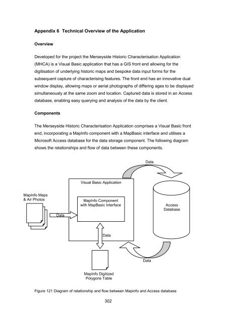
Appendix 6 Technical Overview of the Application<br />
Overview<br />
Developed for the project the Merseyside Historic Characterisation Application<br />
(MHCA) is a Visual Basic application that has a GIS front end allowing for the<br />
digitisation of underlying historic maps and bespoke data input forms for the<br />
subsequent capture of characterising features. The front end has an innovative dual<br />
window display, allowing maps or aerial photographs of differing ages to be displayed<br />
simultaneously at the same zoom and location. Captured data is stored in an Access<br />
database, enabling easy querying and analysis of the data by the client.<br />
Components<br />
The Merseyside Historic Characterisation Application comprises a Visual Basic front<br />
end, incorporating a MapInfo component with a MapBasic interface and utilises a<br />
Microsoft Access database for the data storage component. The following diagram<br />
shows the relationships and flow of data between these components.<br />
Data<br />
Visual Basic Application<br />
MapInfo Maps<br />
& Air Photos<br />
Data<br />
MapInfo Component<br />
with MapBasic Interface<br />
Access<br />
Database<br />
Data<br />
Data<br />
MapInfo Digitized<br />
Polygons Table<br />
Figure 121 Diagram of relationship and flow between Mapinfo and Access database<br />
302
![Ancient Egypt trail [227kb .pdf] - National Museums Liverpool](https://img.yumpu.com/48998817/1/184x260/ancient-egypt-trail-227kb-pdf-national-museums-liverpool.jpg?quality=85)