2014 Digital Yearbook of Homeland Security Awards

Create successful ePaper yourself
Turn your PDF publications into a flip-book with our unique Google optimized e-Paper software.
GSN <strong>2014</strong> <strong>Digital</strong> <strong>Yearbook</strong> <strong>of</strong> <strong>Homeland</strong> <strong>Security</strong> <strong>Awards</strong> Recipients<br />
Government Agency <strong>Awards</strong><br />
Los Angeles International Airport<br />
(LAX) – <strong>2014</strong> Platinum Winner<br />
<strong>Awards</strong> Category:<br />
––––––––––––––––––––––––––––––––––––––––<br />
Most Notable Airport/Aviation <strong>Security</strong> Program<br />
Name <strong>of</strong> Nominated Product, Service,<br />
or Program:<br />
––––––––––––––––––––––––––––––––––––––––<br />
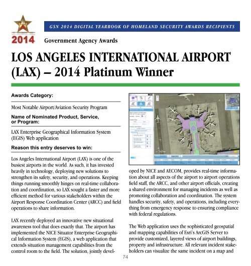
LAX Enterprise Geographical Information System<br />
(EGIS) Web application<br />
Reason this entry deserves to win:<br />
––––––––––––––––––––––––––––––––––––––––<br />
Los Angeles International Airport (LAX) is one <strong>of</strong> the<br />
busiest airports in the world. As such, it has invested<br />
heavily in technology, deploying new solutions to<br />
strengthen its safety, security, and operations. Keeping<br />
things running smoothly hinges on real-time collaboration<br />
and coordination, so LAX sought a faster and more<br />
efficient method for various stakeholders within the<br />
Airport Response Coordination Center (ARCC) and field<br />
operations to share information.<br />
LAX recently deployed an innovative new situational<br />
awareness tool that does exactly that. The airport has<br />
implemented the NICE Situator Enterprise Geographical<br />
Information System (EGIS), a web application that<br />
extends situation management capabilities from the<br />
control room to the field. The solution, jointly devel-<br />
oped by NICE and AECOM, provides real-time information<br />
about all aspects <strong>of</strong> the airport to airport operations<br />
field staff, the ARCC, and other airport <strong>of</strong>ficials, creating<br />
a shared environment for managing incidents as well as<br />
promoting collaboration and coordination. The system<br />
handles security, safety, and operations, including everything<br />
from emergency response to ensuring compliance<br />
with federal regulations.<br />
The Web application uses the sophisticated geospatial<br />
and mapping capabilities <strong>of</strong> Esri’s ArcGIS Server to<br />
provide customized, layered views <strong>of</strong> airport buildings,<br />
property and infrastructure. All relevant incident stakeholders<br />
can visualize the same incident on a map and<br />
74