
You also want an ePaper? Increase the reach of your titles
YUMPU automatically turns print PDFs into web optimized ePapers that Google loves.
The SC-110 is an enhanced GPS-based compass<br />
designed for onboard equipment requiring a heading<br />
signal, such as ARPA, AIS, ECDIS, Scanning Sonar,<br />
Autopilot, etc. This equipment also provides all the<br />
necessary functions the latest GPS navigators do.<br />
Fallback arrangement by 3-axis vibrating-gyro rate<br />
sensor provides accurate and constant heading<br />
information even when the satellite signals are blocked<br />
under bridges or reduced by tall buildings. The SC-110<br />
also regulates the compass function when the ship is<br />
subject to pitching, rolling and yawing. The performance<br />
is not affected by ships’ speed, latitude, geomagnetism,<br />
etc. Settling time is almost instant and follow-up<br />
performance is excellent, achieving 45°/s (SOLAS HSC<br />
Code requires 20°/s as a minimum).<br />
In addition to the heading information and positional<br />
data, SOG (speed over ground), COG (course over<br />
ground) and ROT (rate of turn) are displayed. SOG is<br />
remarkably accurate by decoding the Doppler shift in the<br />
received satellite signals. The interface delivers true<br />
heading and course/speed over ground, rate of turn as<br />
well as GPS fix through up to 11 ports. The heading<br />
information is put out in IEC 61162-2 format at a high<br />
update rate of 25ms to satisfy the high speed data-output<br />
required in the special applications.<br />
The roll and pitch angle is also output both in analog and<br />
digital formats to the equipment, such as sonar,<br />
sounders etc. It is useful in offering the stable echo<br />
pictures by compensating the transmitted/received<br />
beams even in the rough seas. Thus, the SC-110 can be<br />
used as a highly accurate motion sensor.<br />
The SC-110 has a unique Set and Drift mode. When<br />
connected with a water-tracking speed-log, such as DS-<br />
80, it calculates set and drift (tide direction and speed) in<br />
the mode. The display helps a radar operator to manually<br />
enter set and drift for accurate sea stabilization pictures.<br />
The SC-110 consists of 3 antennas on a solid precision<br />
support, a processor unit, and a display unit. The triantenna<br />
system helps reduce the influence of ships’<br />
motions. There are no mechanical parts such as gimbals<br />
and rotating meters, thus the compass is free from<br />
regular maintenance.<br />
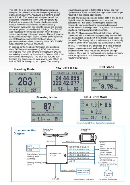
Heading Mode<br />
NAV Data Mode<br />
ROT Mode<br />
Steering Mode<br />
Set & Drift Mode<br />
(Current (Set and Drift) and Distance Run is selectable.)<br />
Interconnection<br />
Diagram<br />
Antenna Unit<br />
SC-1203F<br />
Display Unit<br />
SC-502<br />
DGPS<br />
Beacon Receiver<br />
GR-80<br />
Speed alarm/<br />
Heading alarm<br />
(Contact)<br />
Heading (Backup)<br />
/STW<br />
15/30/50 m<br />
Processor Unit<br />
SC-1101<br />
MJ-7 10 m<br />
IEC 611162-1/-2/AD-10<br />
IEC 611162-1/-2/AD-10<br />
IEC 611162-1/-2/AD-10<br />
IEC 611162-1/-2/AD-10<br />
IEC 611162-1/-2/AD-10<br />
AD-10<br />
Radar<br />
ECDIS<br />
AIS<br />
Autopilot (HCS/TCS)<br />
VideoPlotter<br />
Current Indicator<br />
Scanning Sonar<br />
Repeater Interface*<br />
AMI-GFV "KW-941" etc.<br />
for synchro<br />
AMI-GFV "KW-903-SX" etc.<br />
for step by step<br />
Analog Pitch/Roll<br />
Current Indicator<br />
Scanning Sonar<br />
Compass<br />
Rose*<br />
12-24 VDC<br />
Option or local supply<br />
* For further info, contact our depot