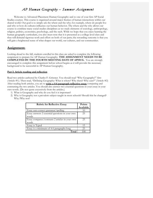
AP Human Geography â Summer Assignment
AP Human Geography â Summer Assignment
AP Human Geography â Summer Assignment

You also want an ePaper? Increase the reach of your titles
YUMPU automatically turns print PDFs into web optimized ePapers that Google loves.
<strong>AP</strong> <strong>Human</strong> <strong>Geography</strong> – <strong>Summer</strong> <strong>Assignment</strong><br />
Welcome to Advanced Placement <strong>Human</strong> <strong>Geography</strong> and to one of your first <strong>AP</strong> Social<br />
Studies courses. This course is organized around major themes of human interactions within our<br />
shared world. Our goal is to simply ask the where and the why; for example, where do people live<br />
and why or how do cultures influence our human behavior. The where and the why allows our<br />
course to combine many social studies disciplines as we study elements of sociology, anthropology,<br />
religion, politics, economics, psychology, and the such. While we hope that you enjoy learning the<br />
human geography curriculum, you also must note that it is presented as a college level class and<br />
thus will demand rigorous work and effort on both of our parts; the rewarding outcome is that you<br />
will gain a heightened sense of what shapes our world, our cultures, and our communities.<br />
<strong>Assignment</strong>:<br />
Looking ahead to the fall, students enrolled in this class are asked to complete the following<br />
assignment to prepare for <strong>AP</strong> <strong>Human</strong> <strong>Geography</strong>. THE ASSIGNMENT NEEDS TO BE<br />
COMPLETED BY THE FOURTH MEETING DATE OF <strong>AP</strong>HUG. You are strongly<br />
encouraged to complete this assignment before school begins as it will provide the necessary<br />
background to be successful in <strong>AP</strong> <strong>Human</strong> <strong>Geography</strong>.<br />
Part I: Article reading and reflection<br />
Read two articles authored by Charles F. Gritzner. You should read “Why <strong>Geography</strong>?” first<br />
(Article #1). Then read, “Defining <strong>Geography</strong>: What is where? Why there? Why care?” (Article #2)<br />
After reading both articles, you are to write a 4-6 paragraph reflective essay comparing and<br />
contrasting the two articles. You should also answer two essential questions in your essay in your<br />
own words. (Do not quote excessively from the articles.)<br />
1) What is <strong>Geography</strong> and why do you feel it is important?<br />
2) Why is <strong>Geography</strong> not a prevalent subject taught in most schools? Should this be changed?<br />
Why/Why not?<br />
Rubric for Reflective Essay<br />
Points<br />
Available<br />
Essay uses correct grammar/spelling 10<br />
Essay answers 2 essential questions in your own 25<br />
words<br />
Essay compares/contrasts 2 articles in your own 25<br />
words<br />
Essay is Typed 15<br />
Essay is a minimum of 4-6 paragraphs long 25<br />
Total 100
Part II: Mapping the World<br />
For the assignment you will be mapping the world. Use the lists provided to label the countries,<br />
cities and selected physical features on the maps. You need to OUTLINE each country in a<br />
different COLOR. You do NOT need to color in the countries. For the physical features follow<br />
the individual instructions on each list to know what to color. You are encouraged to use an Atlas<br />
to complete the maps. Atlases are inexpensive and can be purchased online, from bookstores such<br />
as Barnes and Noble of Books a million as well as regular stores such as Wal-mart or Target. You<br />
can also use online Atlases.<br />
Rubric for Map Packet<br />
Points<br />
Available<br />
All maps labeled 50<br />
All maps colored/outlined with multiple colors 50<br />
Total 100<br />
* If you have any questions about the summer assignment, please contact the<br />
teacher Ms. Long at longja@pwcs.edu.<br />
Article #1<br />
Why <strong>Geography</strong>?<br />
by Charles F. Gritzner<br />
South Dakota State University<br />
Awareness of the World<br />
Never has a nation's people possessed more information, or been in command of more sophisticated means of<br />
acquiring, disseminating, and analyzing data, than do contemporary Americans. In addition to traditional<br />
resources, during recent decades GPS, GIS, satellite imagery, computer mapping, the wonderful resources of<br />
the Internet, and other technological advances have vastly expanded our knowledge of Earth's surface. Yet<br />
given these tremendous resources for enhancing our geographic awareness and global understanding, most<br />
Americans -- living in a Global Age -- continue to possess little more than a Stone Age awareness of the world<br />
about them.<br />
Each day of our lives, we live "geography." Examples affecting each of us on a regular basis can be drawn from<br />
almost every facet of our daily experience. Environmental influences, such as resource availability and cost,<br />
changing weather and climate patterns and their potential impacts, and the threat of spreading diseases and<br />
exotic species, are of increasing concern. Politically we are confronted with a host of issues ranging from<br />
matters pertaining to local taxation, planning, and zoning to regional (if not global) terrorism and other<br />
manifestations of conflict. Economically, we have seen changes in the value of property and commodities at<br />
home, while the stock market has plummeted during recent years as a result of influences ranging from Japan's<br />
economic malaise to Latin America's financial instability. The disproportional distribution of wealth and<br />
opportunity continues to be a major irritant confronting all of humankind. Socially, too, we are affected by the<br />
rapid pace of change in the nation's demographic, social, and ethnic composition and determining our own<br />
position and role on the world stage. Unfortunately, all our citizens are increasingly involved in and dependent<br />
upon a global community about which so many remain dangerously ignorant and unconcerned.
Most Americans lack a well-developed "mental map" of Earth's surface, with its varied mosaic of physical and<br />
human conditions. To these geographic illiterates, our planet assumes the image of a vague, fragmented, and<br />
incredibly confusing hodgepodge of meaningless phenomena that are randomly scattered about on an all but<br />
bare tabula rasa.<br />
Theirs is a world inhabited by faceless peoples whose cultures lack a proud heritage, bonding institutions and<br />
customs, feelings and values, tools and technologies, and essential dimensions of space and time. Places, to the<br />
geographic illiterate, are meaningless. They have no grasp of those unique physical and human features that<br />
give each spot on Earth's surface its own distinctive character, from which each draws its identity and<br />
importance. And the spatial sorting of features into similar and dissimilar places using the geographer's concept<br />
of region holds little meaning or relevance to those who are unaware of their location, nature, and significance.<br />
Their world is composed of vague physical features and life-sustaining environmental systems for which they<br />
lack valid mental images, appropriate terminology, or an understanding of their nature, origin, and importance.<br />
Those who are ignorant of basic geographic principles also have little knowledge of environmental potentials<br />
and limitations. Under these circumstances, how can they possibly be expected to make enlightened decisions<br />
relating to the use and sustainability of our finite global natural endowment?<br />
A Spatial Vacuum<br />
To persons possessing a poorly developed mental map, historical events occurred in a spatial vacuum. "History"<br />
and "geography" remain spatially unlinked and unrelated, severely limiting the significance of one to the other.<br />
Such individuals, although constantly confronted by critical problems and issues, sadly lack the information<br />
needed to make rational analyses, sound judgments, or reasoned attempts at resolution. Further, to the<br />
geographically insensitive, human differences often appear to be threatening and can lead to feelings of<br />
prejudice and acts of discrimination. Such individuals are prisoners of their own ignorance and provincialism.<br />
As a result, they are poorly equipped to assume meaningful citizenship in an increasingly interdependent and<br />
multicultural global community!<br />
It stands as a rather sad and somewhat inexplicable indictment of this country's priorities and approach to<br />
education that among the world's industrial nations, Americans rank among the least literate in geographic<br />
knowledge and, perhaps worse, geographic curiosity. Examples of this ignorance are numerous. So, too, are the<br />
increasingly apparent, appalling, and often damaging consequences -- be they social, economic, political,<br />
military, or environmental -- that result from our failure to provide citizens with adequate geographic<br />
instruction.<br />
In most countries of the Western urban-industrial world (and in many less-developed countries as well),<br />
geography constitutes the "core" of the social science curriculum. The United States is unique among these<br />
nations in relegating geography to a relatively minor role in both the elementary and secondary curriculum.<br />
Some progress has been made in terms of enhancing geography's position in the curriculum during recent years,<br />
particularly through the various initiatives of the National Geographic Society. Despite these efforts and others,<br />
however, most of the world's educated people are much better informed about the world (and often about the<br />
United States!) than are the majority of our own citizens.<br />
In an increasingly complex, troubled, and closely intertwined world community of cultures and nations,<br />
Americans simply do not know much about our global neighbors (or, for that matter, about ourselves in a<br />
geographic sense). We have little understanding of, or feeling for, other lands and peoples. We are largely<br />
ignorant of their ways of living, environments and natural resources, human capabilities, and cultural<br />
attainments. We also know little about their similarities and differences, their hopes and dreams, or their<br />
problems and needs. Perhaps of greatest importance, we fail to understand how closely linked and important we<br />
have become to one another. How can Americans possibly expect to maintain a position of respect and<br />
leadership in a world of cultures and nations about which we know – and seemingly care -- so little?<br />
Now, more than ever, citizens can ill afford to remain ignorant of the world about them. The compression of<br />
time and space resulting from the technological "explosion" has placed even our most remote neighbors at our<br />
very doorstep. It is essential that all Americans understand and appreciate their role and responsibility in an
increasingly complex global community. Each of us must be aware of Earth's fundamental physical and cultural<br />
patterns; of its key locations, distributions, patterns, and divisions; and of its primary linkages, movements,<br />
networks, and systems. We also must understand our planet's basic areas of production and consumption, its<br />
major spatial interrelationships, and its causes and hot spots of conflict. A populace that remains largely<br />
ignorant of fundamental geographic knowledge surely limits a nation's ability to perform and compete<br />
effectively on the global stage.<br />
The Necessity of Geographic Education<br />
<strong>Geography</strong> education is no longer a curricular luxury. It is an absolute necessity. If the United States is to<br />
endure, we must ensure that all students -- kindergarten through college -- be given the key to the future: an<br />
understanding of the world that only a rigorous geography curriculum can provide. Few people question the<br />
need for history education; why, then, do so many question the importance of teaching geography? History,<br />
after all, is but a recording of past geography; a society that lives a "good geography" will surely leave a good<br />
history. <strong>Geography</strong> has been described as "learning for living" and is a science with a strong futuristic emphasis.<br />
It is also the ancient and time-honored science that can best provide the essential knowledge needed to ensure<br />
that our citizens are prepared to assume responsible and enlightened leadership in today's complex and<br />
demanding global community. T. S. Eliot wrote, "We shall not cease from exploration, and the end of all our<br />
exploring will be to arrive where we started and to know the place for the first time." Today, all citizens<br />
certainly must be able to think globally, while continuing to act locally. By better knowing the world about us,<br />
we come to better know ourselves -- whether at home, or as members of the global community.<br />
Dr. Charles F. Gritzner is a professor of geography at South Dakota State University. This article first<br />
appeared in Journal of <strong>Geography</strong> 102 (2003): 90-91; it appears on <strong>AP</strong> Central through a permission<br />
agreement between the College Board and the National Council for Geographic Education.<br />
Article #2<br />
Defining <strong>Geography</strong>: What is Where, Why There, and<br />
Why Care?<br />
by Charles F. Gritzner<br />
South Dakota State University<br />
The Nature of <strong>Geography</strong><br />
Most everyone knows that history is the study of events through time. Basically, historians ask "What happened<br />
when and why then?" But many people, it seems, have a problem defining geography. One reason why<br />
geography has languished in the curricula of many American schools is that so few people understand the<br />
nature of the discipline or its relevance to our everyday lives. What is geography? What is its unique<br />
perspective? What do geographers do? Why is geography important? Why should we teach (and learn)<br />
geography in the schools? These are questions that have gone largely unanswered in American education. This<br />
brief essay presents an easily taught, understood, and remembered definition of geography. It has been used<br />
with great success by the author in his own teaching, public speaking, and professional writing for more than a<br />
decade. It works beautifully, and I believe that it will work for you and your students as well.<br />
Immanuel Kant, writing some two centuries ago, may have been the first scholar to identify clearly and<br />
succinctly the unique nature of both history and geography. In essence, he observed that history organizes and<br />
analyzes events in terms of when they occurred (the temporal context, or time). <strong>Geography</strong>, on the other hand,<br />
focuses upon Earth's features and conditions through asking where they are found (the spatial context, or<br />
location). Both history and geography, then, are methodologies -- unique ways of thinking about our world and<br />
its events, conditions, patterns, and consequences. Following Kant's rationale, a simple definition of geography<br />
emerges: if "When?" is the realm of history, then "Where?" is the primary focus of geographic inquiry.
If we can agree that the spatial method of organization and analysis is at the heart of geography and the<br />
geographic perspective, then this reality must be reflected in any definition of the science. Here, however, a<br />
stumbling block looms on the horizon: What is "spatial analysis"? When most people think of "space," after all,<br />
they associate it with astronomy, not geography. In a geographic context, "space" is defined as a portion of<br />
Earth's surface. Location, place, area, region, territory, distribution, and pattern are all closely related spatial<br />
concepts.<br />
A Concise Definition<br />
The following definition incorporates all essential elements traditionally recognized as being fundamental to<br />
geography: it is the study, as I wrote in the Journal of <strong>Geography</strong>, of "what is where, why there, and why<br />
care?"* To this foundation can be added further information. For example, at the college level I often add<br />
"pertaining to the various physical and human features of Earth's surface, including their conditions,<br />
interactions, spatial distributions, and patterns." The definition is flexible in that it can easily incorporate any<br />
and all other perspectives on the nature of the discipline. The following diagram further amplifies each of the<br />
four elements contained within the definition.<br />
What Is Where Why There and Why Care?<br />
(Phenomenological) (Spatial) (Analytical) (Implicational)<br />
All features of Earth's<br />
surface that occur in spatial<br />
distribution:<br />
Location:<br />
Agents<br />
Importance<br />
• Physical features<br />
(nature)<br />
• <strong>Human</strong> features<br />
(culture)<br />
• Site (specific)<br />
• Situation (relative)<br />
• Accessibility<br />
• Isolation<br />
Distribution Processes Relevance<br />
Pattern Interrelationships Action/reaction<br />
Scale:<br />
• Local<br />
• Regional<br />
• Global<br />
Descriptive<br />
Conceptual<br />
Some definitions of geography (including that developed by the National Geographic Society) emphasize<br />
cultural ecology -- the relationship humans establish with the natural environment. Both geographers and<br />
cultural ecologists are concerned with the ways in which humans culturally adapt to, use, and modify the<br />
environments they occupy. Geographers, however, are particularly interested in what kinds of ecological<br />
practices occur within different cultures -- who is doing what, where, and why? The emphasis is on location and<br />
the characteristics of place. For example, "What is?" might be a particular type of ecological relationship, such<br />
as tropical shifting cultivation, pastoral nomadism, or mining. "Where?" then places the activity in a particular<br />
location and perhaps with a particular group, such as Amerindians of the Amazon Basin, Tuareg of the Western
Sahara, or residents of Minnesota's Iron Range. "Why there?" can be quite complex because in most instances,<br />
many factors are involved. Shifting cultivation, for example, might include such factors as heavily leached,<br />
hence infertile, tropical soils; cultural isolation and tradition; or sustainability. In the case of the Tuareg,<br />
certainly the region's arid environment, a longstanding pastoral tradition, and the consequences of overgrazing<br />
are important. A concentration of iron ore, the need for iron in an industrial society, and proximity to Great<br />
Lakes shipping lanes all help shed light on northern Minnesota mining activity. Finally, "Why care?" provides<br />
an opportunity to establish the importance of the foregoing activities in their particular location, as well as in<br />
their natural and cultural geographic contexts.<br />
The Definition in Practice<br />
This definition of geography works well for several reasons. First, it emphasizes that geography is a<br />
methodology. It stresses the geographic way of organizing and analyzing information pertaining to the location,<br />
distribution, pattern, and interactions of the varied physical and human features of Earth's surface. All<br />
geographic inquiry should begin with the question, "Where?" Geographers and all other scientists ask "Why?"<br />
And, of course, most major Earth-bound events, features, and conditions can and often do have some impact on<br />
our lives, thereby begging the question, "Why care?"<br />
Second, the definition incorporates all traditional geographic subjects, themes, and traditions. In teaching, no<br />
matter what topic is being stressed or approach being taken, it can be easily integrated into the definition.<br />
Third, the definition functions at all scales. In studying towns and cities, for example, site (specific location and<br />
condition of a place) can often explain their presence. For example, New York City is located at the mouth of<br />
the Hudson River with a natural harbor protected by Long Island; San Diego and Seattle are on excellent natural<br />
harbors; and Denver is at the eastern terminus of a pass through the Rocky Mountains. South Dakota's largest<br />
and fastest growing city, Sioux Falls, affords a splendid example to illustrate the importance of "Where?"<br />
When the city was settled in 1856, eastern South Dakota was inhabited by people of the Sioux culture. The<br />
city's name, itself, implies the importance of location and place: the falls on the Big Sioux River provided<br />
power for a mill around which the city was originally established. Through time, the city grew primarily<br />
because of its location in the wettest, hence most agriculturally productive, area of the state. It also served as a<br />
major highway and rail hub. Finally, rapid growth continued because of its location at the intersection of two<br />
interstate highways. An example on the global scale, petroleum resources in the Middle East certainly have<br />
contributed to a host of conflicts, and "petro-politics" surely will be a major issue for decades to come.<br />
Production, distribution, consumption, and trade all impact the lives of several billion people daily.<br />
<strong>Geography</strong> has projected a very fuzzy image of its content and methodology for far too long. The definition<br />
presented here is clear and concise. It places no limitation on what geographers study (literally anything found<br />
on Earth's surface); it clearly identifies the discipline's unique methodology -- the spatial dimension of features,<br />
including where they are, in what patterns they occur, what important relationships exist between or among<br />
features, and so forth. If geography is to be taught as a science, the distribution of features must be explained --<br />
that is, we must address the question, "Why there?" Finally, all geographic teaching and learning should relate<br />
to the human need to know, emphasizing "Why care?" The definition presented here identifies in simple, easily<br />
taught, and easily learned terms the extreme complexity of geography.<br />
* Charles F. Gritzner, "What Is Where, Why There, and Why Care?" Journal of <strong>Geography</strong>101, no. 1<br />
(January/February 2002), pp. 38-40.<br />
Charles F. "Fritz" Gritzner received his Ph.D. from Louisiana State University and is now midway in his fifth<br />
decade of college teaching. Since 1980, he has been on the faculty of South Dakota State University, where he<br />
holds the rank of distinguished professor of geography. Gritzner is a past president of the National Council for<br />
Geographic Education (NCGE) and is a recipient of the council's George J Miller Award, which honors,<br />
according to the NCGE Web site, "a distinguished record of service to geography education."
Part II:<br />
Mapping the World<br />
Packet<br />
LONGJA 5/22/12 6:29 AM<br />
Deleted: Practice
Canada, the United States and Greenland map page 8<br />
1. Do NOT label the 50 States or LABEL their Capitals!!!!!!<br />
2. Label and outline the 2 countries and 1 territory on the map (U.S.A., Canada, and Greenland) and label their<br />
capital cities. Outline each nation in a different color so they are easy to recognize. Do not use blue to label<br />
counties near water.<br />
3. Label the 10 provinces and 3 territories of Canada, and their capital cities.<br />
4. Label the following physical features:<br />
• Appalachian Mountains<br />
• Rocky Mountains<br />
• Great Plains<br />
5. Shade in blue and label the following water features:<br />
Mississippi River<br />
Rio Grande<br />
St. Lawrence River Atlantic Ocean<br />
Hudson Bay<br />
Great Lakes<br />
Pacific Ocean<br />
Gulf of Mexico<br />
Mexico, Central America and the Caribbean map page 21<br />
1. Label and outline the following countries and label their capital cities. Outline each nation a different color<br />
so they are easy to recognize. Do not use blue to shade countries near water.<br />
Bahamas<br />
Honduras<br />
Belize<br />
Jamaica<br />
Costa Rica<br />
Mexico<br />
Cuba<br />
Nicaragua<br />
Dominican Republic<br />
Panama<br />
El Salvador<br />
Guatemala<br />
Haiti<br />
2. Label the following physical features:<br />
Baja California<br />
Sierra Madre Oriental<br />
Sierra Madre Occidental<br />
Yucatan Peninsula<br />
3. Shade blue and label the following water features:<br />
Rio Grande<br />
Atlantic Ocean<br />
Caribbean Sea<br />
Gulf of California<br />
Gulf of Mexico<br />
Panama Canal<br />
Pacific Ocean
South America map page 30<br />
1. Label and outline the 12 countries and 3 dependencies of South America and label their capital cities.<br />
Outline each nation a different color so they are easy to recognize. Do not use blue to shade countries near<br />
water.<br />
2. Label the following physical features:<br />
Andes Mountains<br />
Brazilian Highlands<br />
Pampas<br />
Atacama Desert<br />
Llanos<br />
3. Shade blue and label the following water features:<br />
Amazon River<br />
Atlantic Ocean<br />
Caribbean Sea<br />
Pacific Ocean<br />
Western Europe map page 43<br />
1. Label and outline the 24 countries and label their capital cities. Outline each nation a different color so they<br />
are easy to recognize. Do not use blue to shade countries near water.<br />
2. Label the following physical features:<br />
Alps Mountains<br />
Pyrenees Mountains<br />
3. Shade blue and label the following water features:<br />
Danube River<br />
Adriatic Sea<br />
Aegean Sea<br />
Arctic Ocean<br />
Atlantic Ocean<br />
Baltic Sea<br />
North Sea<br />
Mediterranean Sea<br />
Rhine River<br />
Seine River<br />
Thames River<br />
Strait of Gibraltar<br />
North Sea<br />
Eastern Europe map page 55<br />
1. Label and outline the 12 countries and label their capital cities. Outline each nation a different color so they<br />
are easy to recognize. Do not use blue to shade countries near water.<br />
2. Label the following physical features:<br />
Carpathian Mountains<br />
3. Shade blue and label the following water features:<br />
Adriatic Sea Baltic Sea Black Sea
Northern Eurasia map page 67<br />
1. Label and outline the 15 countries and label their capital cities. Outline each nation a different color so they<br />
are easy to recognize. Do not use blue to shade countries near water.<br />
2. Label the following physical features:<br />
Caucasus Mountains<br />
Ural Mountains<br />
Altai Mountains<br />
3. Shade blue and label the following water features:<br />
Amur River<br />
Ob River<br />
Aral Sea<br />
Arctic Ocean<br />
Baltic Sea<br />
Bering Straight<br />
Black Sea<br />
Caspian Sea<br />
Lake Baikal<br />
Southwest Asia map page 80<br />
1. Label and outline the 15 countries and label their capital cities. Outline each nation a different color so they<br />
are easy to recognize. Do not use blue to shade countries near water.<br />
2. Label the following physical features:<br />
Taurus Mountains<br />
Zagros Mountains<br />
Elburz Mountains<br />
3. Shade blue and label the following water features:<br />
Euphrates River<br />
Tigris River<br />
Aegean Sea<br />
Arabian Sea<br />
Persian Gulf<br />
Red Sea<br />
Mediterranean Sea<br />
Northern Africa map page 93<br />
1. Label and outline the 5 countries and 1 territory of North Africa and label their capital cities. Outline each<br />
nation a different color so they are easy to recognize. Do not use blue to shade countries near water.<br />
2. Label the following physical features:<br />
Atlas Mountains<br />
Sinai Peninsula<br />
Sahara Desert<br />
3. Shade blue and label the following water features:<br />
Nile River<br />
Red Sea<br />
Suez Canal<br />
Straight of Gibraltar
West Africa map page 102<br />
1. Label and outline the 16 countries (and 1 island country) and label their capital cities. Outline each nation a<br />
different color so they are easy to recognize. Do not use blue to shade countries near water.<br />
2. Label the following physical features:<br />
Sahara Desert<br />
3. Shade blue and label the following water features:<br />
Atlantic Ocean<br />
Lake Chad<br />
Central Africa map page 111<br />
1. Label and outline the 8 countries (1 is an island country) and label their capital cities. Outline each nation a<br />
different color so they are easy to recognize. Do not use blue to shade countries near water.<br />
2. Shade blue and label the following water features:<br />
Congo River<br />
Eastern and Southern Africa map page 120<br />
1. Label and outline the 24 countries (3 are island nations) and label their capital cities. Outline each nation a<br />
different color so they are easy to recognize. Do not use blue to shade countries near water.<br />
2. Label the following physical features:<br />
Mt. Kilimanjaro<br />
Kalahari Desert<br />
Namib Desert<br />
3. Shade blue and label the following water features:<br />
Nile River<br />
Atlantic Ocean<br />
Indian Ocean<br />
Lake Victoria<br />
South Asia map page 134<br />
1. Label and outline the 8 countries (2 are island nations) and label their capital cities. Outline each nation a<br />
different color so they are easy to recognize. Do not use blue to shade countries near water.<br />
2. Label the following physical features:<br />
Himalaya Mountains<br />
Eastern/Western Ghats<br />
Mt. Everest<br />
Deccan Plateau<br />
Hindu Kush Mountains<br />
3. Shade blue and label the following water features:<br />
Indus River<br />
Ganges River<br />
Brahmaputra River<br />
Indian Ocean<br />
Bay of Bengal
Central and Eastern Europe map page 147<br />
1. Label and outline the 6 countries and label their capital cities. Outline each nation a different color so they<br />
are easy to recognize. Do not use blue to shade countries near water.<br />
2. Label the 4 main island of Japan – Hokkaido, Honshu, Shikoku and Kyushu<br />
3. Label the following physical features:<br />
Gobi Desert<br />
Mt. Fuji<br />
Altai Mountains<br />
4. Shade blue and label the following water features:<br />
Huang He (yellow) River<br />
Yangtze River<br />
East China Sea Pacific Ocean Sea of Japan<br />
South China Sea<br />
Southeast Asia map page 159<br />
1. Label and outline the 10 countries (1 is very small) and label their capital cities. Outline each nation a<br />
different color so they are easy to recognize. Do not use blue to shade countries near water.<br />
2. Shade blue and label the following water features:<br />
Mekong River<br />
Celebes Sea<br />
Indian Ocean<br />
Pacific Ocean<br />
Straight of Malacca<br />
Philippine Sea<br />
Australia and Oceania map page 171<br />
1. Label and outline Australia and New Zealand and label their capital cities. Outline each nation a different<br />
color so they are easy to recognize. Do not use blue to shade countries near water.<br />
2. Label the 3 regions of Oceania, and the island groups within each region<br />
Melanesia Micronesia Polynesia<br />
Fiji Guam Hawaii<br />
New Caledonia Marshall Islands American Samoa<br />
Papua New Guinea<br />
Solomon Islands<br />
3. Label the following physical features:<br />
Great Barrier Reef<br />
Great Dividing Range<br />
4. Shade blue and label the following water features:<br />
Indian Ocean<br />
Pacific Ocean<br />
Coral Sea<br />
Timor Sea