Disaster Management Plan 2011-12 of Cuttack District
Disaster Management Plan 2011-12 of Cuttack District
Disaster Management Plan 2011-12 of Cuttack District

You also want an ePaper? Increase the reach of your titles
YUMPU automatically turns print PDFs into web optimized ePapers that Google loves.
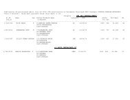
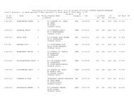
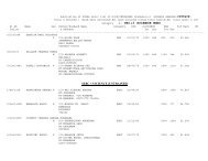
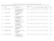
39 Deputy director Horticulture <strong>Cuttack</strong> 2342965 94374<strong>12</strong>209<br />
40 Dist Fire Officer <strong>Cuttack</strong> 2306183<br />
41 General Manager DIC <strong>Cuttack</strong> 2344852<br />
42 Station Director AIR <strong>Cuttack</strong> 23019<strong>12</strong><br />
43 Executive Engineer CDA <strong>Cuttack</strong> 2503565<br />
Overview <strong>of</strong> <strong>Cuttack</strong>:<br />
<strong>Cuttack</strong> district is a narrow strip <strong>of</strong> land spreading from east to west. Topographically, <strong>Cuttack</strong> has two prominent<br />
divisions i.e hilly terrain on the west and Mahanadi delta 0plain on the east. The highly fertile and densely populated land<br />
is criss-crossed by hundreds <strong>of</strong> rivers and rivulets. These water bodies function both as tributaries and as distributaries <strong>of</strong><br />
the Mahanadi river system. Large portion <strong>of</strong> the land mass is low lying and gets submerged during flood. People <strong>of</strong><br />
<strong>Cuttack</strong> largely depend upon agriculture as the primary means <strong>of</strong> livelihood. The vast network <strong>of</strong> irrigation canals<br />
established by the Britishers after the great famine <strong>of</strong> 1866 is the backbone <strong>of</strong> agriculture. <strong>Cuttack</strong> city is still the<br />
commercial capital <strong>of</strong> Orissa with the Malgodown controlling the trade throughout the state.<br />
<strong>Cuttack</strong> district is highly prone to natural disasters like flood and cyclone due to its geographical location. An<br />
unprecedented super cyclone affected this district during 1999 and flood in major rivers in the year 1972,<br />
1973,1975,1978,1980, 1982, 1984, 1991, 1999, 2000, 2001, 2003, 2006 and 2008 causing heavy loss to lives and<br />
property.<br />
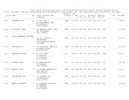
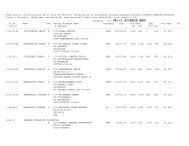
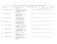
1.6 <strong>Cuttack</strong> <strong>District</strong> at a Glance:<br />
1 Location Longitude : 84º58' to 86º20' East<br />
Latitude: 20º03' to 20º40' North<br />
2 Geographical Area 3932 Sq.Km.<br />
3 Sub-Divisions 3<br />
Sadar, Athgarh, Banki<br />
4 Tahasils 15<br />
5 Blocks 14<br />
6 ULBs 4<br />
7 G.Ps 342<br />
8 Villages 1950<br />
9 Inhabited village 1856<br />
10 Un-inhabited 94<br />
11 No. <strong>of</strong> Wards in G.Ps 5475<br />
<strong>12</strong> No.<strong>of</strong> Zilla Parishad Member 46<br />
13 Police Stations 35<br />
14 Assembly Constituency 9<br />
15 Parliamentary Constituency 3<br />
16 Population (2001 Census)<br />
23,41,094<br />
Male<br />
Female<br />
<strong>12</strong>,07,781 11,33,313<br />
17 Density <strong>of</strong> Population (per Sq. Km) 595<br />
18<br />
(a)<br />
Rural population<br />
Rural Households<br />
16,99,964<br />
3,44,349<br />
19<br />
(a)<br />
Urban Population<br />
Urban Households<br />
6,41,130<br />
1,21977<br />
20 <strong>Cuttack</strong> City population 5.35 Lakhs<br />
21 SC population 4,46,789<br />
22 ST population 83,591<br />
23 No <strong>of</strong> BPL families ( 1997 census) 1,79,221<br />
24 Decadal Population Growth (1991-2001) (+) 14.02<br />
25 Sex ratio ( per 1000 male) 938<br />
26 Literacy rate 76.66 %<br />
10