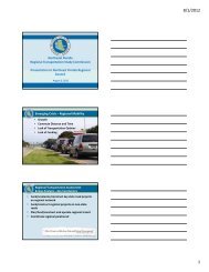
Duval County - Northeast Florida Regional Council
Duval County - Northeast Florida Regional Council
Duval County - Northeast Florida Regional Council

Create successful ePaper yourself
Turn your PDF publications into a flip-book with our unique Google optimized e-Paper software.
I 95<br />
Lorain St<br />
N Pearl St<br />
N Pearl St<br />
Silver St<br />
Kentucky St<br />
Indiana St<br />
Ohio St<br />
Illinois St<br />
Rose St<br />
1st St<br />
30°25'0"N<br />
36<br />
81°40'0"W<br />
Clark Rd<br />
37<br />
State Hwy 5A<br />
Sisson Dr<br />
81°39'0"W<br />
38<br />
39<br />
Imeson Park Blvd<br />
65 65<br />
81°38'0"W<br />
440<br />
30°25'0"N<br />
£¤ 17 £¤ 17<br />
I 95<br />
McCallman Rd<br />
Van Dyck Rd<br />
Unnamed Street<br />
Motel<br />
JACKSONVILLE<br />
Jericho Rd<br />
Fields Ave<br />
£¤ 17 UV 105<br />
Sisson Dr<br />
Heckscher<br />
Parker Ave Parker<br />
Rota Ave<br />
State Hwy 163<br />
Fenwick Rd<br />
Hayden Rd<br />
%2<br />
22<br />
Gun Club Rd<br />
State Hwy 105<br />
D<br />
2.83ft<br />
State Hwy 105<br />
64 64<br />
UV 105 UV 105 DUVAL COUNTY<br />
Broward Rd<br />
US Hwy 17<br />
Maxwell<br />
I 95<br />
Zoo Rd<br />
Somers Rd S<br />
5th St<br />
4th St<br />
3rd St<br />
30°24'0"N<br />
Tarleton Rd<br />
§¨¦ 95<br />
§¨¦ 95<br />
Linda Dr N<br />
Fraleigh Ave<br />
State Hwy 117<br />
Iva Pl<br />
Burton Ave<br />
Escambia St<br />
Carlton St<br />
N Shore Dr<br />
Elwood Ave<br />
W 68th St<br />
W 63rd St<br />
W 61st St<br />
Chestnut Dr<br />
W 70th St<br />
W 69th St<br />
W 62nd St<br />
W 60th St<br />
Vermillion St<br />
Perry St<br />
W 46th St<br />
Springfield Blvd<br />
W 41st St<br />
Sunset Dr<br />
Broward Rd<br />
63 63<br />
W 67th St<br />
W 40th St<br />
Bruce St<br />
State Hwy 111<br />
W 44th St<br />
W 42nd St<br />
Andress St<br />
W 48th St<br />
W 45th St<br />
W 43rd St<br />
D<br />
Laura St N<br />
14.2ft<br />
E 45th St<br />
%2<br />
36<br />
E 54th St<br />
E 43rd St<br />
E 65th St<br />
Oakwood St<br />
Wakefield Ave<br />
Bloxham Ave<br />
61 E 55th St<br />
61<br />
33 60 000m. N<br />
30°23'0"N<br />
Ashford St<br />
Vashti Rd<br />
Calvert St<br />
Appia n Way<br />
Gar denia Ln<br />
Tory Pl N<br />
Valley Forge Rd<br />
81°40'0"W<br />
Estes Rd<br />
4 36 000m. E<br />
N Shore Dr<br />
W 62nd St<br />
Druid Hill Ln<br />
Crestwood St<br />
Calvin Ave<br />
W 71st St<br />
Duray St<br />
Ivy St<br />
Demper Dr<br />
W 49th St<br />
Beechwood St<br />
Tudor<br />
W<br />
W<br />
Trout Riv<br />
Sherwood St<br />
61st St<br />
Silver Plz<br />
Sapphire Dr<br />
Kathryn Dr<br />
Barberie St<br />
54th St<br />
37<br />
Alpine St<br />
Clinton St<br />
Barberie St<br />
Rydholm St<br />
Trout River Ter<br />
Rolliston St<br />
Lucky Dr W<br />
Lucky Dr E<br />
W 55th St<br />
W 53rd St<br />
E 41st St<br />
E 40th St<br />
E<br />
61st St<br />
E 59th St<br />
E 56th St<br />
81°39'0"W<br />
E 46th St<br />
Sycamore St<br />
E 48th St<br />
E 47th St<br />
Oakwood St<br />
Gregory Pl<br />
62 62<br />
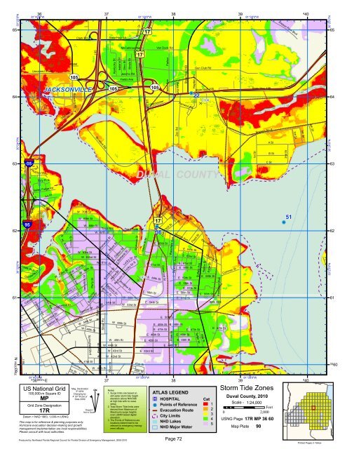
US National Grid<br />
100,000-m Square ID<br />
MP<br />
Grid Zone Designation<br />
17R<br />
Datum = NAD 1983, 1,000-m USNG<br />
Mag. Declination<br />
5 o 40'W<br />
Changing by<br />
4' 30" W per yr<br />
Date 2009<br />
This map is for reference & planning purposes only.<br />
Hurricane evacuation decision-making and growth<br />
management implementation are local responsibilities.<br />
Please consult with local authorities.<br />
Produced by <strong>Northeast</strong> <strong>Florida</strong> <strong>Regional</strong> <strong>Council</strong> for <strong>Florida</strong> Division of Emergency Management, 2009-2010<br />
#<br />
Diagram<br />
Not to Scale<br />
GN<br />
^<br />
Notes:<br />
1. Surge limits are based on<br />
still water storm tide height<br />
elevation above NAVD88<br />
at high tide with no wave<br />
setup.<br />
2. Total Storm Tide limits were<br />
derived from Maximum of<br />
Maximums surge heights<br />
over LIDAR based digital<br />
elevation.<br />
3. The Points of Reference are<br />
locations determined to be<br />
relevant to emergency managment<br />
officials.<br />
E 50th St<br />
E 44th St<br />
Trout River Dr<br />
Lawton Ave<br />
E 48th St<br />
38<br />
E 64th St<br />
E 63rd St<br />
E 61st St<br />
E 60th St<br />
E 59th St<br />
E 58th St<br />
E 46th St<br />
E 57th St<br />
E 56th St<br />
E 45th St<br />
Floyd St<br />
Buffalo Ave<br />
E 47th St<br />
Telfair St<br />
ATLAS LEGEND<br />
®v HOSPITAL<br />
%2 Points of Reference<br />
Evacuation Route<br />
City Limits<br />
NHD Lakes<br />
NHD Major Water<br />
Page 72<br />
Kenilworth St<br />
Nelms St<br />
E 56th St<br />
Alta St<br />
Virginia St<br />
Edge St<br />
E 59th St<br />
Cat<br />
1<br />
2<br />
3<br />
4<br />
5<br />
Evergreen Ave<br />
55th St E<br />
E 47th St<br />
Cummer St<br />
39<br />
81°38'0"W<br />
A St<br />
B St<br />
C St<br />
Storm Tide Zones<br />
<strong>Duval</strong> <strong>County</strong>, 2010<br />
Scale - 1:24,000<br />
Feet<br />
0 2,000<br />
USNG Page 17R MP 36 60<br />
Map Plate 90<br />
2nd St<br />
51<br />
%2<br />
83<br />
97<br />
84<br />
98<br />
85<br />
4 40<br />
68 69 70 71 72 73 74 75<br />
51 52 53 54 55 56 57 58 59 60<br />
34 35 36 37 38 39 40 41 42 43<br />
18 19 20 21 22 23 24 25 26 27<br />
64 65<br />
47 48<br />
8 9 10 11 12 13 14 15 16<br />
28<br />
29 30 31 32 33<br />
17<br />
1 2 3 4 5 6 7<br />
30°24'0"N<br />
30°23'0"N<br />
130 131 132 133 134 135 136<br />
122 123 124 125 126 127 128 121 129<br />
115 118 119<br />
111 110 112 113 114 116 117 120<br />
99 100 101 102 103 104 105 106 107 108 109<br />
86<br />
87<br />
88<br />
89<br />
90<br />
76<br />
61<br />
44<br />
91<br />
77<br />
62<br />
45<br />
92<br />
78<br />
63<br />
46<br />
Printed Pages in Yellow<br />
93<br />
79<br />
94<br />
80<br />
95<br />
81<br />
66<br />
49<br />
96<br />
82<br />
67<br />
50<br />
33 60