Download
Download
Download

You also want an ePaper? Increase the reach of your titles
YUMPU automatically turns print PDFs into web optimized ePapers that Google loves.
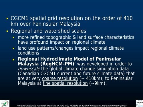
• CGCM1 spatial grid resolution on the order of 410<br />
km over Peninsular Malaysia<br />
• Regional and watershed scales<br />
• more refined topographic & land surface characteristics<br />
have profound impact on regional climate<br />
• land use patterns/changes impact regional climate<br />
conditions<br />
• Regional Hydroclimate Model of Peninsular<br />
Malaysia (RegHCM-PM)’ was developed in order to<br />
downscale the global climate change simulation data<br />
(Canadian CGCM1 current and future climate data) that<br />
are at very coarse resolution (~ 410km), to Peninsular<br />
Malaysia at fine spatial resolution (~9km).<br />
National Hydraulic Research Institute of Malaysia, Ministry of Natural Resources and Environment (NRE)