AmAzon CAttle footprint - Greenpeace
AmAzon CAttle footprint - Greenpeace
AmAzon CAttle footprint - Greenpeace

Create successful ePaper yourself
Turn your PDF publications into a flip-book with our unique Google optimized e-Paper software.
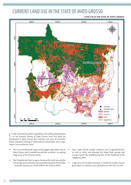
Current Land use in the State of Mato Grosso<br />
Land use in the State of Mato Grosso<br />
Xingu’s indigenous park<br />
Lucas do Rio Verde<br />
Chapada dos Parecis<br />
State capital<br />
Municipality capitals<br />
Agriculture<br />
Sugar cane<br />
Pasture<br />
Degraded forest<br />
Cattle ranching has been expanding and fuelling deforestation<br />
in the Amazon Biome of Mato Grosso state, but land use<br />
distribution in Mato Grosso also includes vast areas of savannah,<br />
where industrial farming of monocultures, particularly soya crops,<br />
impact four prominent areas.<br />
• The Lucas do Rio Verde region is the biggest agriculture area in<br />
Mato Grosso and it extends beyond the savannah, occupying<br />
large areas of the Amazon forest.<br />
• The Chapada dos Parecis region, between the land strip and the<br />
remaining Amazon Biome, has expanded along the Porto Velho<br />
– Santarém export axis, which follows the Amazon River.<br />
• Soya crops (which require intensive use of agrochemicals),<br />
as well as cattle, also threaten the Xingu River springs and<br />
occupy mainly the neighbouring area on the Southeast of the<br />
indigenous park.<br />
• Large areas of Cerrado (savannah) in Southeast of Mato Grosso<br />
given place to extensive soya plantations in the last 20 years.<br />
12