AmAzon CAttle footprint - Greenpeace
AmAzon CAttle footprint - Greenpeace
AmAzon CAttle footprint - Greenpeace

You also want an ePaper? Increase the reach of your titles
YUMPU automatically turns print PDFs into web optimized ePapers that Google loves.
Table of Contents<br />
Introduction . . . . . . . . . . . . . . . . . . . . . . . . . . . . 3<br />
HOW IS AMAZON DEFORESTATION MEASURED?. . . . . . . . . 4<br />
EXPANSION OF CATTLE RANCHING IN THE LEGAL AMAZON . . . 5<br />
DISTRIBUTION OF INFRASTRUCTURE . . . . . . . . . . . . . . . . 6<br />
The Impact of THE INDUSTRY . . . . . . . . . . . . . . . . . . . 7<br />
Cattle Footprint in Mato Grosso. . . . . . . . . . . . . . . 8<br />
Cattle ranching expansion areas in the<br />
Amazon biome, Mato Grosso state . . . . . . . . . . . . . . . . 8<br />
The Far North (Nortão) . . . . . . . . . . . . . . . . . . . . . . . . 8<br />
Amazon Biome Strip . . . . . . . . . . . . . . . . . . . . . . . . . . 8<br />
The BR-163 – Alta Floresta road axis . . . . . . . . . . . . . . . 9<br />
The springs of the Xingu River . . . . . . . . . . . . . . . . . . . 9<br />
MODIS IMAGE AND LAND USE . . . . . . . . . . . . . . . . . . . . 10<br />
Threatened Heritage. . . . . . . . . . . . . . . . . . . . . . . . 11<br />
Current Land use in the State of Mato Grosso. . . . . . 12<br />
SMOKING KILLS. . . . . . . . . . . . . . . . . . . . . . . . . . . . 13<br />
Land use map methodology . . . . . . . . . . . . . . . . . . . 13<br />
reasons to stop destruction of the<br />
Amazon RAINFOREST . . . . . . . . . . . . . . . . . . . . . . . . 14<br />
What must be done . . . . . . . . . . . . . . . . . . . . . . . . . 14<br />
The Brazilian Government must. . . . . . . . . . . . . . . . . . 14<br />
INDUSTRIALIsED Countries must . . . . . . . . . . . . . . . . . . 14<br />
INDUSTRY must. . . . . . . . . . . . . . . . . . . . . . . . . . . . . . 15<br />
BANK AND INVESTORS . . . . . . . . . . . . . . . . . . . . . . . . . . 15<br />
Citizens CAN . . . . . . . . . . . . . . . . . . . . . . . . . . . . . . . . 15<br />
REFERENCES. . . . . . . . . . . . . . . . . . . . . . . . . . . . . . 15<br />
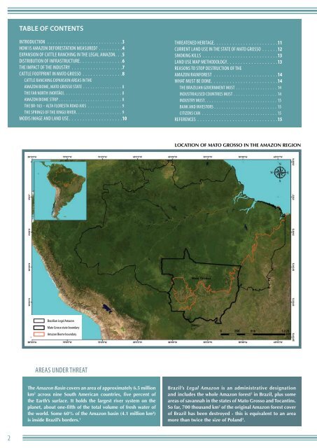
Location of Mato Grosso in the Amazon Region<br />
Brazilian Legal Amazon<br />
Mato Grosso state boundary<br />
Amazon Biome boundary<br />
Areas under threat<br />
The Amazon Basin covers an area of approximately 6.5 million<br />
km 2 across nine South American countries, five percent of<br />
the Earth’s surface. It holds the largest river system on the<br />
planet, about one-fifth of the total volume of fresh water of<br />
the world. Some 60% of the Amazon basin (4.1 million km²)<br />
is inside Brazil’s borders. 1<br />
Brazil’s Legal Amazon is an administrative designation<br />
and includes the whole Amazon forest 2 in Brazil, plus some<br />
areas of savannah in the states of Mato Grosso and Tocantins.<br />
So far, 700 thousand km 2 of the original Amazon forest cover<br />
of Brazil has been destroyed - this is equivalent to an area<br />
more than twice the size of Poland 3 .<br />
2