The Conservation and Sustainable Use of Freshwater ... - IUCN
The Conservation and Sustainable Use of Freshwater ... - IUCN
The Conservation and Sustainable Use of Freshwater ... - IUCN

You also want an ePaper? Increase the reach of your titles
YUMPU automatically turns print PDFs into web optimized ePapers that Google loves.
• Overgrazing <strong>of</strong> pastures <strong>and</strong> excessive mowing;<br />
• Irrigation <strong>and</strong> other impacts caused by man.<br />
<strong>The</strong> dominant factor determining destabilization <strong>of</strong> the<br />
environment is the Syrdarya river flow reduction. During<br />
the period <strong>of</strong> 1961-1970, the Syrdarya river flow diminished<br />
down to an average <strong>of</strong> 6.7 km 3 /year, with a minimum<br />
flow <strong>of</strong> 3.2 km 3 /year in 1965 <strong>and</strong> a maximum <strong>of</strong> 10.6 km 3 /<br />
year in 1969. During the period <strong>of</strong> 1971-1980, the average<br />
annual flow was 2.3 km 3 /year. In 1981-1986, it was 0.72<br />
km 3 /year (Fig. 1). In some low-water years the Syrdarya<br />
river flow actually failed to reach the sea.<br />
In 1987, the division <strong>of</strong> the Aral Sea started. <strong>The</strong> water<br />
area was separated by a natural undersea shoal in Berg<br />
Straits (level <strong>of</strong> 40.7 abs m) into two parts: the Small<br />
(northern) Sea <strong>and</strong> the Large (southern) Sea (Fig. 2). <strong>The</strong><br />
Berg Straits shoal is an important element <strong>of</strong> undersea<br />
relief. It represents a flat, slightly inclined height that is<br />
formed by fine <strong>and</strong> loamy s<strong>and</strong>s <strong>and</strong> is 14.0 - 15.0 km long,<br />
<strong>and</strong> 17.0 - 17.5 km wide. <strong>The</strong> Berg Straits shoal, which<br />
is located at the level <strong>of</strong> 42 – 41 abs m, is a natural barrier<br />
preventing overflow <strong>of</strong> water from the Small Sea to the<br />
Large Sea. Due to the Syrdarya river inflow a positive water<br />
balance started developing, the surplus <strong>of</strong> which overflowed<br />
to the Large Sea. By 1992, the height <strong>of</strong> overflow<br />
between these two water bodies constituted about 3 m: the<br />
Small Sea level was 40.2 abs. m, <strong>and</strong> the Large Sea level<br />
was 37 abs m. As a result <strong>of</strong> these processes, more than<br />
33,000 km <strong>of</strong> the former sea bottom were exposed, with<br />
their inherent lithogenous complexes, forms, <strong>and</strong> elements<br />
<strong>of</strong> sea relief. (Dukhovny et al, -)<br />
In natural conditions within the boundaries <strong>of</strong> the current<br />
delta, the Syrdarya river channel, which spreads over 189<br />
km, provided inflow to the Aral Sea <strong>of</strong> an average annual<br />
capacity up to 490 m 3 /sec, supplying the delta with water<br />
1960<br />
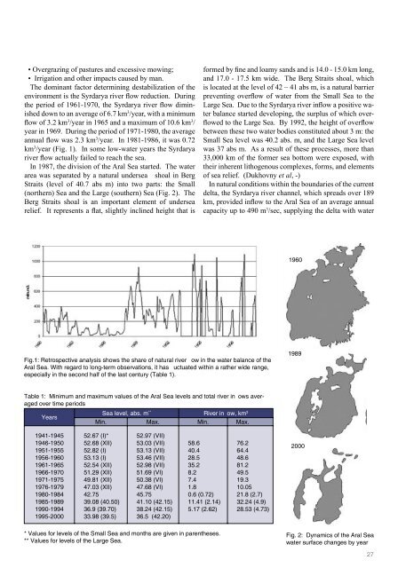
Fig.1: Retrospective analysis shows the share <strong>of</strong> natural river flow in the water balance <strong>of</strong> the<br />
Aral Sea. With regard to long-term observations, it has fluctuated within a rather wide range,<br />
especially in the second half <strong>of</strong> the last century (Table 1).<br />
1989<br />
Table 1: Minimum <strong>and</strong> maximum values <strong>of</strong> the Aral Sea levels <strong>and</strong> total river inflows averaged<br />
over time periods<br />
Years<br />
Sea level, abs. m ** River inflow, km 3<br />
Min. Max. Min. Max.<br />
1941-1945<br />
1946-1950<br />
1951-1955<br />
1956-1960<br />
1961-1965<br />
1966-1970<br />
1971-1975<br />
1976-1979<br />
1980-1984<br />
1985-1989<br />
1990-1994<br />
1995-2000<br />
52.67 (I)*<br />
52.68 (XII)<br />
52.82 (I)<br />
53.13 (I)<br />
52.54 (XII)<br />
51.29 (XII)<br />
49.81 (XII)<br />
47.03 (XII)<br />
42.75<br />
39.08 (40.50)<br />
36.9 (39.70)<br />
33.98 (39.5)<br />
52.97 (VII)<br />
53.03 (VII)<br />
53.13 (VII)<br />
53.46 (VII)<br />
52.98 (VII)<br />
51.69 (VI)<br />
50.38 (VI)<br />
47.68 (VI)<br />
45.75<br />
41.10 (42.15)<br />
38.24 (42.15)<br />
36.5 (42.20)<br />
58.6<br />
40.4<br />
28.5<br />
35.2<br />
8.2<br />
7.4<br />
1.8<br />
0.6 (0.72)<br />
11.41 (2.14)<br />
5.17 (2.62)<br />
76.2<br />
64.4<br />
48.6<br />
81.2<br />
49.5<br />
19.3<br />
10.05<br />
21.8 (2.7)<br />
32.24 (4.9)<br />
28.53 (4.73)<br />
2000<br />
* Values for levels <strong>of</strong> the Small Sea <strong>and</strong> months are given in parentheses.<br />
** Values for levels <strong>of</strong> the Large Sea.<br />
Fig. 2: Dynamics <strong>of</strong> the Aral Sea<br />
water surface changes by year<br />
27