The Conservation and Sustainable Use of Freshwater ... - IUCN
The Conservation and Sustainable Use of Freshwater ... - IUCN
The Conservation and Sustainable Use of Freshwater ... - IUCN

You also want an ePaper? Increase the reach of your titles
YUMPU automatically turns print PDFs into web optimized ePapers that Google loves.
are increasing in the mountains. <strong>The</strong> zone <strong>of</strong> intensive<br />
flow consumption shifts to the flow forming zone due to<br />
expansion <strong>of</strong> urban settlements <strong>and</strong> recreational zones.<br />
In the zone <strong>of</strong> water flow forming the absolute majority<br />
<strong>of</strong> the rivers, lakes, <strong>and</strong> water reservoirs are characterized<br />
by high water quality, although in the inl<strong>and</strong> basins salty<br />
(Issyk-Kul <strong>and</strong> Karakul) <strong>and</strong> salty lakes (Rangkul <strong>and</strong><br />
Shorkul) exist. In the glacier zone, the water-mineralization<br />
is 100-150 mg/l, in the middle zones <strong>of</strong> mountains it<br />
is 200-300 mg/l, in some foothill places it can reach 500<br />
mg/l. Content <strong>of</strong> specific pollutants (oil products, metals)<br />
does not exceed or slightly exceeds the MPC (Maximum<br />
Permissible Concentration). In general, the quality <strong>of</strong><br />
water in the region is suitable for the basic types <strong>of</strong> water<br />
consumption. However, in the last years, the dangerous<br />
trend <strong>of</strong> a biological intensification processes (eutrophication)<br />
was noted. This trend, which is possibly due to<br />
recreation load increase <strong>and</strong> to the drawing <strong>of</strong> water from<br />
small rivers without control, has resulted in the deterioration<br />
<strong>of</strong> water quality.<br />
<strong>The</strong> quality <strong>of</strong> national <strong>and</strong> trans-boundary waters in the<br />
consumption zone <strong>of</strong> water flow, under the influence <strong>of</strong><br />
regulatory processes <strong>and</strong> anthropogenic pollution, is bad.<br />
<strong>The</strong> transformation <strong>of</strong> water flow quality is more evident<br />
in the increase <strong>of</strong> mineralization levels in the river courses.<br />
Increase <strong>of</strong> mineralization is connected with concentration<br />
<strong>of</strong> all mineral components downstream. <strong>The</strong> most significant<br />
changes occur below the big collectors flowing<br />
into the rivers. During the past ten years, the following<br />
tendencies concerning change <strong>of</strong> superficial water quality<br />
were noted:<br />
• Stabilization <strong>of</strong> the mineral composition <strong>and</strong> delay <strong>of</strong><br />
mineralization growth;<br />
• Decrease <strong>of</strong> general level <strong>of</strong> organic pollution <strong>and</strong><br />
level <strong>of</strong> saprogenity <strong>of</strong> currents, as the average annual<br />
concentrations <strong>of</strong> ions <strong>of</strong> pollutants (nitrates, oil products,<br />
pesticides, phenols, <strong>and</strong> metals) in the zones <strong>of</strong><br />
increased anthropogenic influence, which is connected<br />
with the decreasing <strong>of</strong> technologically outmoded (obsolete)<br />
plants <strong>and</strong> with high-water levels by the end <strong>of</strong><br />
1990;<br />
• Increase <strong>of</strong> water eutrophication <strong>of</strong> the small <strong>and</strong> medium<br />
rivers in the mountain -foothills belts as a result<br />
<strong>of</strong> urbanization <strong>and</strong> recreation processes.<br />
Ecological risks related to the use <strong>of</strong> water<br />
resources <strong>and</strong> natural events<br />
Among the possible negative influences <strong>of</strong> water resources<br />
on humans’ sustainable development <strong>and</strong> biodiversity<br />
conservation are the spontaneous hydro-meteorological<br />
events, particularly the catastrophic floods, mudflows,<br />
<strong>and</strong> water-breaks, including breaks <strong>of</strong> mountain lakes. In<br />
Central Asia, 23 large mountain lakes can be broken by<br />
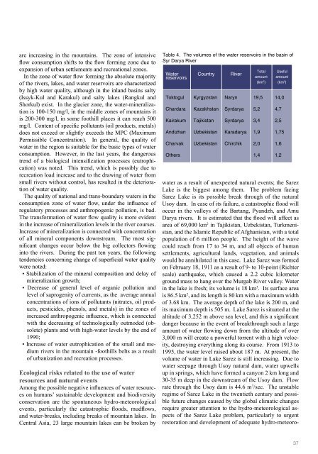
Table 4. <strong>The</strong> volumes <strong>of</strong> the water reservoirs in the basin <strong>of</strong><br />
Syr Darya River<br />
Water<br />
reservoirs<br />
Toktogul<br />
Chardara<br />
Kairakum<br />
Andizhan<br />
Charvak<br />
Others<br />
Country<br />
Kyrgyzstan<br />
Kazakhstan<br />
Tajikistan<br />
Uzbekistan<br />
Uzbekistan<br />
River<br />
Naryn<br />
Syrdarya<br />
Syrdarya<br />
Karadarya<br />
Chirchik<br />
Total<br />
amount<br />
(km 3 )<br />
19,5<br />
<strong>Use</strong>ful<br />
amount<br />
(km 3 )<br />
water as a result <strong>of</strong> unexpected natural events; the Sarez<br />
Lake is the biggest among them. <strong>The</strong> problem facing<br />
Sarez Lake is its possible break through <strong>of</strong> the natural<br />
Usoy dam. In case <strong>of</strong> its failure, a catastrophic flood will<br />
occur in the valleys <strong>of</strong> the Bartang, Py<strong>and</strong>zh, <strong>and</strong> Amu<br />
Darya rivers. It is estimated that the flood will affect as<br />
area <strong>of</strong> 69,000 km 2 in Tajikistan, Uzbekistan, Turkmenistan,<br />
<strong>and</strong> the Islamic Republic <strong>of</strong> Afghanistan, with a total<br />
population <strong>of</strong> 6 million people. <strong>The</strong> height <strong>of</strong> the wave<br />
could reach from 17 to 34 m, <strong>and</strong> all objects <strong>of</strong> human<br />
settlements, agricultural l<strong>and</strong>s, vegetation, <strong>and</strong> animals<br />
would be annihilated in this case. Lake Sarez was formed<br />
on February 18, 1911 as a result <strong>of</strong> 9- to 10-point (Richter<br />
scale) earthquake, which caused a 2.2 cubic kilometer<br />
ground mass to hang over the Murgab River valley. Water<br />
in the lake is fresh; its volume is 18 km 3 . Its surface area<br />
is 86.5 km 2 , <strong>and</strong> its length is 80 km with a maximum width<br />
<strong>of</strong> 3.68 km. <strong>The</strong> average depth <strong>of</strong> the lake is 200 m, <strong>and</strong><br />
its maximum depth is 505 m. Lake Sarez is situated at the<br />
altitude <strong>of</strong> 3,252 m above sea level, <strong>and</strong> this a significant<br />
danger because in the event <strong>of</strong> breakthrough such a large<br />
amount <strong>of</strong> water flowing down from the altitude <strong>of</strong> over<br />
3,000 m will create a powerful torrent with a high velocity,<br />
destroying everything along its course. From 1913 to<br />
1995, the water level raised about 187 m. At present, the<br />
volume <strong>of</strong> water in Lake Sarez is still increasing. Due to<br />
water seepage through Usoy natural dam, water upwells<br />
up in springs, which have formed a canyon 2 km long <strong>and</strong><br />
30-35 m deep in the downstream <strong>of</strong> the Usoy dam. Flow<br />
rate through the Usoy dam is 44.6 m 3 /sec. <strong>The</strong> unstable<br />
regime <strong>of</strong> Sarez Lake in the twentieth century <strong>and</strong> possible<br />
future changes caused by the global climatic changes<br />
require greater attention to the hydro-meteorological aspects<br />
<strong>of</strong> the Sarez Lake problem, particularly to urgent<br />
restoration <strong>and</strong> development <strong>of</strong> adequate hydro-meteoro-<br />
5,2<br />
3,4<br />
1,9<br />
2,0<br />
1,4<br />
14,0<br />
4,7<br />
2,5<br />
1,75<br />
1,6<br />
1,2<br />
37